What was the motivation behind CGG developing geostatistical inversion?
As a global geoscience technology leader, CGG invests significant resources in R&D initiatives to push the boundaries of subsurface imaging technologies. With the global rise in unconventional development and the growing need to improve the economic return on unconventional reservoirs, the ability to identify fine-bed, heterogeneous and discontinuous reservoirs is crucial to unlocking trapped hydrocarbons through targeted lateral well drilling campaigns. These targets typically occur in tight, discontinuous reservoirs with a thickness of less than 20 ft.
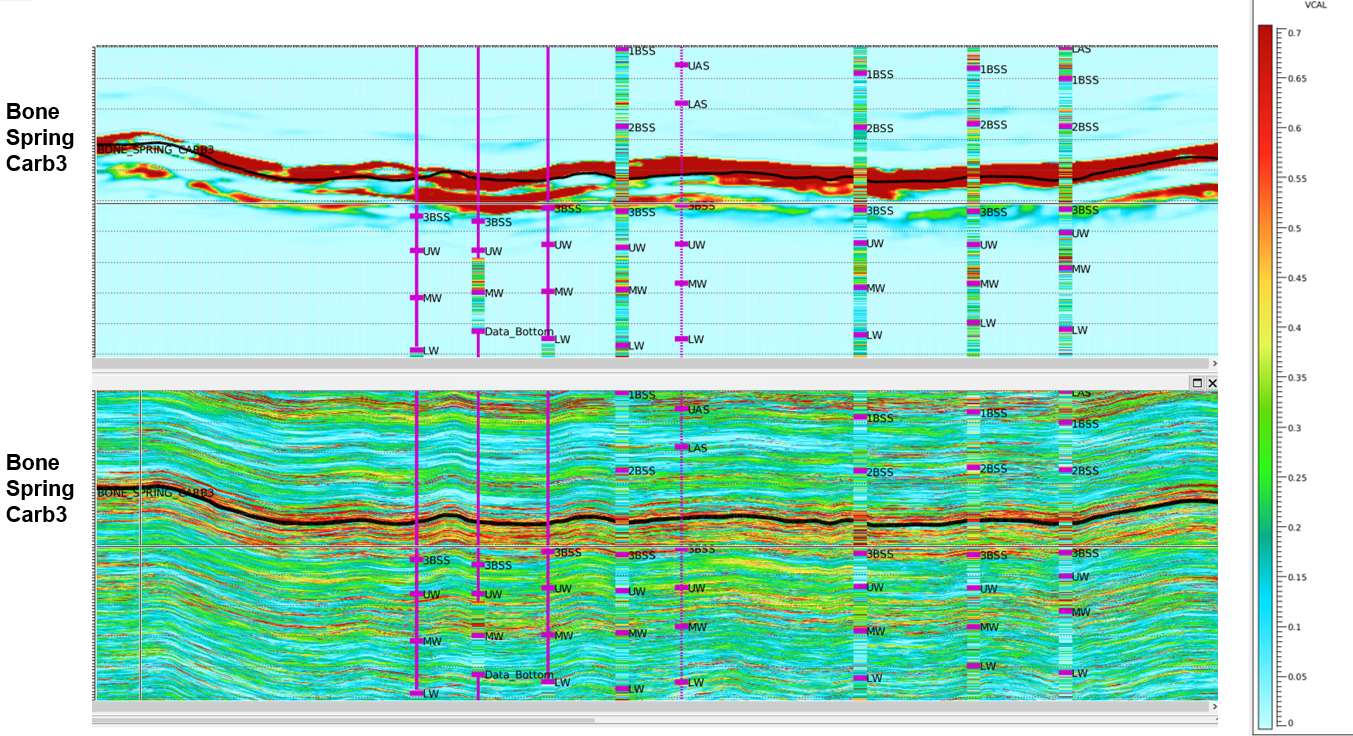
Reservoir detail from traditional inversion techniques, such as deterministic inversion, is restricted by the vertical seismic wavelets, which typically represent a thickness of 40 ft. For CGG’s clients, it was essential to get closer to the reservoir and enhance the vertical and lateral characterization of the subsurface beyond deterministic inversion. CGG responded to this challenge by developing ResPack HD geostatistical inversion—an innovative solution combining new-generation 3D seismic with plentiful well data collected within onshore U.S unconventional basins.
Why are more Permian Basin operators now using geostatistical inversion as an exploration and development tool? What differentiates it from other inversion techniques?
Having worked on various subsurface projects within the Permian Basin since the early 2010’s, I understand its geological and engineering complexities, which ultimately influence hydrocarbon production performance. The Permian Basin is not an easily characterized layer cake system from a geological, geochemical or engineering perspective. In addition, with the lower commodity prices we’re seeing, our clients have needed to further de-risk and high-grade their development acreage to maximize their ROI.
Our ResPack HD geostatistical inversion technique provides a quantitative solution, highlighting lithological and rock property variations, between well control, at a vertical scale of 5-15 ft. Compared to deterministic inversions, our geostatistical inversion workflow maximizes 3D seismic and well log data to enhance understanding of the subsurface.
How long has ResPack HD been available?
ResPack HD was developed five years ago. This advanced workflow collects real-rock data from core and cuttings to calibrate the petrophysical and Rock Physics model. This inclusion ensures the geological constraint of lithofacies which are ultimately upscaled into the geostatistical inversion using CGG GeoSoftware’s RockMod software.
Like any new technology, there’s always a time lag between product release and industry uptake. This has been a priority for CGG; providing geostatistical inversion feasibility studies to prove the technique’s value and upside: whether it helps to improve drilling efficiencies and/or increase production rates. We now have a number of successful case studies highlighting these benefits and we’re taking them to our Permian Basin operators to make them aware of the additional value geostatistical inversion brings above and beyond traditional deterministic inversions. It’s great to see more and more Permian Operators embracing this workflow and recognizing its value.
How does CGG verify the uplift geostatistical inversion brings to exploration and development?
Verification is key! In anything we do, we confirm that the results from our ResPack HD geostatistical inversion provide incremental value to our clients’ operations and a greater ROI. We make an early verification by including blind well testing in the final stage of the geostatistical inversion. This gives confidence that the rock property volumes generated by this technique are the most probable. Subsequently, these volumes are used for exploration and development activities.
Ultimately, of course, we see verification when our clients drill their wells and/or perform a post-mortem as to why particular wells underperform or overperform. Two recent studies validated how application of geostatistical inversion improved the production performance of lateral wells. Higher-producing wells hosted a high contact rate with geostatistical inversion ‘pay lithology’ volumes while lower-producing wells hosted a higher contact rate with ‘non-pay lithology’ volumes. With this knowledge, and armed with the geostatistical inversion’s ‘most probable’ lithologies volume, our clients were able to optimally design their lateral well development plan.
Our most recent Permian Basin project, focused on the Wolfcamp Formation in Howard County of the Midland Basin. Our client independently tested our ResPack HD lithofacies volume by overlaying the MWD GR of six lateral wells to, in essence, provide blind well validations of the ResPack HD ‘most probable lithofacies’ away from vertical well control. Our client found that the correlation between low GR (carbonate-dominant lithofacies) and predicted ‘carbonate lithofacies’ from ResPack HD was positive. This validated the outputs and gave confidence to our client who now has the capability to identify fine-bed, heterogeneous reservoir compartments throughout their asset in order to optimally target, drill, complete and produce.
The two projects I’ve just mentioned enabled our ResPack HD clients to better understand subsurface heterogeneity within their target intervals. With this improved insight, they are now equipped to optimize their development and production plans to increase their ROI through improved well placement and ultimately more productive wells.
CGG is obviously having great success with geostatistical inversion. What’s next? Any plans for extending this beyond onshore North America?
We’re actively working to integrate the geostatistical inversion outputs into our 3D petroleum systems modeling workflows to provide not just subsurface rock properties, but also model accumulation volumes of hydrocarbons within the reservoir.
Outside of onshore North America, we’ve seen recent successful applications of geostatistical inversion on projects in the Gulf of Mexico and offshore Brazil and Mozambique where our reservoir characterization team were able to map and characterize discontinuous reservoir channel sands to help our clients identify drilling prospects. Also, in the Middle East, CGG applied ResPack HD to characterize a Lower Cretaceous reservoir for a field offshore Abu Dhabi for ADNOC and ADOC late last year. This project leveraged the vast amount of sedimentological data available for this formation, which is crucial in further reducing geological uncertainties within the final 3D geological model.
Given the high investment involved in acquiring or licensing seismic and well data, we believe our geostatistical inversion workflow is the ideal solution for maximizing this investment – to help identify fine-bed reservoir distribution, place wells with confidence, and ultimately enhance hydrocarbon production.
Learn more about ResPack HD geostatistical inversion and other reservoir characterization packages for conventional and unconventional resources at http://cgg.com/respack.
Industry Articles
Integrated sedimentological and seismic reservoir characterization studies as inputs into a Lower Cretaceous reservoir geomodel, offshore Abu Dhabi (First Break, October 2019)
Technical Paper
URTeC: 2153909
Maximizing Recoverable Reserves in Tight Reservoirs Using Geostatistical Inversion from 3-D Seismic: A Case Study From The Powder River Basin, USA