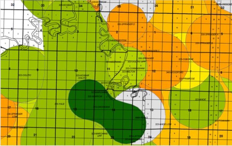
This graphic shows an overlay of WhiteStar Grid (black and white land grid) with TGS field and pool data (colored polygons) to provide basic geographical context for oil and gas basemaps. (Source: TGS)
TGS and WhiteStar have formed a partnership on Nov. 7 to jointly provide a robust solution combining TGS well data and WhiteStar land grid GIS data, coupled with field and pool data.
WhiteStar provides expert land grid GIS data and software land mapping solutions for the oil and gas industry, forestry, government, and others. This partnership allows for TGS to add WhiteStar products to its data offerings for clients who need access to land grid and cultural data. These insights will be fully integrated into TGS’ mapping applications, R360 and LONGBOW, for fast, easy access. Furthermore, WhiteStar will offer TGS’ validated well header and field and pool GIS data through its sales channels for customers who need additional location data to fully utilize the value of WhiteStar products.
“Customers will greatly benefit from a best-in-breed integration of our highly curated land data and the well-respected TGS field, pool, and validated well header data,” Robert White, CEO of WhiteStar Corp., said.
R360, a unique geoscience data portal, integrates TGS data libraries with existing technologies and applications. It allows customers to readily access the industry’s largest volume of high-integrity global geoscience data, including detailed well statistics and well performance information. In December, a significant user-guided upgrade to the R360 portal will be rolled out, with features including enhanced text and map search functions.
Recommended Reading

TPH: Lower 48 to Shed Rigs Through 3Q Before Gas Plays Rebound
2024-03-13 - TPH&Co. analysis shows the Permian Basin will lose rigs near term, but as activity in gassy plays ticks up later this year, the Permian may be headed towards muted activity into 2025.
For Sale, Again: Oily Northern Midland’s HighPeak Energy
2024-03-08 - The E&P is looking to hitch a ride on heated, renewed Permian Basin M&A.

E&P Highlights: Feb. 26, 2024
2024-02-26 - Here’s a roundup of the latest E&P headlines, including interest in some projects changing hands and new contract awards.

Gibson, SOGDC to Develop Oil, Gas Facilities at Industrial Park in Malaysia
2024-02-14 - Sabah Oil & Gas Development Corp. says its collaboration with Gibson Shipbrokers will unlock energy availability for domestic and international markets.

E&P Highlights: Feb. 16, 2024
2024-02-19 - From the mobile offshore production unit arriving at the Nong Yao Field offshore Thailand to approval for the Castorone vessel to resume operations, below is a compilation of the latest headlines in the E&P space.