On the eve of the anticipated opening of a new era for hydrocarbon exploration in Mexico, many anticipations and considerations for application of geophysical methods exist. As companies look to explore the shallow and deepwaters in the Mexican Gulf of Mexico (GoM), there is much to be understood. The good news: Much has been gleaned from historical activity on the U.S. side. How can this knowledge be applied to accelerating and refining understanding of hydrocarbon potential in Mexican waters?
With much published literature from the macro scale (basin-forming aspects) to the more micro scale (reservoir properties), explorers have access to geotechnical data and information that increase their understanding of the regional geology and depositional systems expected to be encountered. The best way to summarize the opportunity is presented in Table 1, which shows well density in the shelf and deepwater regions between the U.S. and Mexico.
| Well Type | Water Depth | U.S. | Mexico |
|---|---|---|---|
| Exploratory | <100 m | 14,778 | 474 |
| Development | <100 m | 29,840 | na |
| Exploratory | >100 m | 4,204 | 117 |
| Development | >100 m | 4,361 | na |
TABLE 1. Mexico currently has no development wells in water depths greater than 100 m (305 ft). (Source: TGS)
So what can be expected from the rocks? Generally speaking, between U.S. analogs and the historical shallow-water drilling in Mexico, there are active petroleum systems that have formed with similar sources, seals, traps and migration.
But subject to which sub-region is being explored, companies will also encounter fold belts, salt basins/provinces, extensional rifting, deepwater abyssal plains, carbonate shelf and ramps plus some unique influences from the Chicxulub meteor impact crater and other tectonic influences still in their infancy of understanding. Taking all this into account, there remain many questions to be answered and theories to be tested.
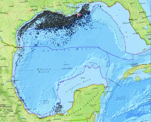
FIGURE 1. From this map it is obvious that there is plenty of room for exploration in the Mexican GoM. (Source: TGS)
Right technology, right time
With the advancement of geophysical technology (primarily over the past 30 years), active explorers will have the opportunity to apply the right technology in the right environment to accelerate geotechnical understanding. Looking at the development of the U.S. GoM from the geophysical perspective, two fundamental drivers are at play: acquisition and imaging technology.
On the acquisition side, early activity (1980s to 1990s) was based on 2-D marine streamer data with streamer lengths in the 3-km to 6-km (2-mile to 4-mile) range. By the late ’90s advancement in technology permitted longer offset 2-D data and the early recordings of narrow-azimuth multistreamer 3-D operations. From there we moved to wide-azimuth (WAZ) recordings. Today we have access to multi-WAZ (MWAZ) and various configurations of full-azimuth (FAZ), with offsets to 20 km (12 miles) or more that continue to provide new and valuable insight into important large- and small-scale observations.
Imaging advances
Concurrent with the advancement of field acquisition technology has been the computational and algorithm advancements in imaging. With the increasing richness in azimuths and offsets for marine data, the sheer volume of data has not only benefited from increased compute capacity/speed but the increased statistics available to imaging algorithms. Key benchmark applications have included depth migration (vs. time), applications to handle the heterogeneities within the rocks, the variety/advancement of depth migration options such as Kirchoff, wave equation migration, reverse time migration (RTM), least squares RTM, and noise and multiple removal algorithms.
Present-day leading-edge technology advancements include applications such as broadband acquisition and processing solutions; interpolation, orthorhombic migration, full waveform inversion, image-guided tomography (IGT, Figure 2) and a host of additional applications that provide a modern toolkit with considerably greater means.
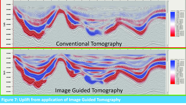
FIGURE 2. IGT provides an uplift in imaging. (Source: TGS)
Benefits to Mexico
So what does all this mean for marine seismic exploration and development of the Mexican GoM? First, the importance of large-scale regional 2-D data cannot be underestimated. High-quality regional 2-D data will allow improved sub-basin/fairway definition, the ability to delineate/high-grade key elements of “source to sink” sedimentation and understanding of the structural and stratigraphic elements controlling the formation of prospective hydrocarbon traps. More importantly, these data will provide key information to optimize the application of purpose-designed 3-D configurations and technology application for each particular region/play type.
Secondly, for 3-D applications, complex structural provinces (including salt basins requiring supra and subsalt resolution) have shown the value of wider azimuth, longer offset recording.
As areas mature and require application of 3-D, companies will have the opportunity to optimize solutions. In today’s fast-paced environment companies will be required to evaluate the multitude of design and imaging options but will have the luxury of applying a “fit-for-purpose” solution. Compared to the historical development of the U.S. GoM, application of fit-for-purpose solutions should provide greater return on investment, improved risk reduction and acceleration of the pace of unlocking the prize.
Geotechnically, all prospective play types and subject data requirements must be considered. For the southern Mexican GoM, specific consideration will be the prominence of more carbonate reservoirs, where understanding fracture density and orientation for both reservoir zones and potential seal may be a key factor. Sectored (orthorhombic) migration and the observed velocity changes associated with rock heterogeneities become critical in risk assessment and meaningful in certain play types. However, if MWAZ or FAZ data have not been acquired, the application of this technology becomes limited.
In any assessment the level of technology application and the volume of data being considered will become paramount. In each of the above design/imaging considerations, cost considerations are readily identified. Cost, however, is only one factor. The timing of the receipt of interpretable and advanced products will be key in company assessments. With the volume of data being created during acquisition and the complex imaging algorithms available, companies will have to incorporate requests and requirements in their exploration timelines. As a final consideration, future technologies that might be applicable to data if acquired “correctly” today should also be assessed.
With the application of advanced acquisition equipment and technology combined with advanced imaging technology, industry’s interpretation of the subsurface will benefit from all it has accomplished over the past 30 years. Without a doubt, exploration in the Mexican GoM will benefit from a considerable uplift on the starting point for the U.S. GoM.
Recommended Reading

The Jones Act: An Old Law on a Voyage to Nowhere
2024-04-12 - Keeping up with the Jones Act is a burden for the energy industry, but efforts to repeal the 104-year-old law may be dead in the water.

US Orders Most Companies to Wind Down Operations in Venezuela by May
2024-04-17 - The U.S. Office of Foreign Assets Control issued a new license related to Venezuela that gives companies until the end of May to wind down operations following a lack of progress on national elections.

Vietnam Seeks Delicate Balance Among US, China, Russia
2024-02-08 - Ongoing U.S. tensions with China and Russia offer Vietnam an opportunity to boost economic ties with the former if American investors can steer past geopolitical smokescreens and destine funds for infrastructure, power and LNG projects all somewhat tied to Vietnam’s manufacturing sector.
Kinder Morgan Exec: Building Pipelines ‘Challenging, but Manageable’
2024-04-05 - Allen Fore, vice president of public affairs for Kinder Morgan, said building anything, from a new road to an ice cream shop, can be tough but dealing with stakeholders up front can move projects along.

FERC Again Approves TC Energy Pipeline Expansion in Northwest US
2024-04-19 - The Federal Energy Regulatory Commission shot down opposition by environmental groups and states to stay TC Energy’s $75 million project.