2 San Antonio, Texas-based Alaskan Crude Corp. received state approval for a new oil and gas unit on the southern boundary of the Prudhoe Bay Unit. The 6,363-acre Arctic Fortitude Unit is on the North Slope one to two miles southwest of Deadhorse Airport, Alaska. The unit is in sections 25, 26, 35 and 36 of Township 10n-13e, and 29 through 34 of Township 10n-14e, Umiat Meridian. The nearest production is #1 Hailstorm wildcat. That 9,840-ft. well is in Section 2-9n-13e in the Northeast Storms Unit.
3 Westport Oil & Gas LP (Anadarko Petroleum Corp.), Houston, completed a Uinta Basin wildcat nine miles northwest of Bonanza, Utah. The #823-34A WKRP, Section 34-8s-23e, eastern Uintah County, flowed 1.19 million cu. ft. of gas and 140 bbl. of water daily. The 9,150-ft. well was completed on a 20/64-in. choke in undisclosed intervals in Wasatch and Mesaverde.
4 Petro-Canada Resources (USA) Inc., Calgary, will drill an 8,000-ft. wildcat on the southwestern flank of the Uinta Basin about 18 miles northeast of Price in northeastern Utah. The objective of #11-21 Bryner, in Section 11-12s-12e, northern Carbon County, include Mesaverde and Mancos gas zones. The well is 4.5 miles west-northwest of #1-16 Keel Ranch Unit in Section 16-12s-13e. That 12,646-ft. well produced 13.9 million cu. ft. of gas from Mancos from 8,084 to 8,134 ft.
5 Double Eagle Petroleum Co., Casper, Wyo., will drill an exploratory test on the Utah Hingeline/Overthrust in the area of a seismic project near the town of Joseph in Sevier County, Utah. The #1 Joseph will be in Section 24-25s-4w, southeast of Joseph and 19 miles southwest of Wolverine Gas & Oil Co.'s Covenant Field, a Navajo oil accumulation being developed near the town of Sigurd.
6 Victory Capital Holdings Corp., Ladera Ranch, Calif., has applied for a drilling permit for a nonproducing area of Montana. The 6,500-ft. remote wildcat is in Section 36-30n-40e, Valley County, about 11 miles southwest of Glasgow. The objectives of the well were not disclosed, but possibly include Madison and/or Nisku and Duperow, according to IHS Energy. The location is 17 miles west-southwest of Lustre Field, which has produced 6.6 million bbl. of oil, 1.6 billion cu. ft. of gas and 22.9 million bbl. of water from Madison zones above 6,200 ft. since 1982. Victory Capital is a development-stage company controlled by Jon Fullencamp. Its Northeast Glasgow prospect will be drilled on a farm-out from Laser Exploration Inc., Midland.
7 A discovery well was drilled by Dallas-based Petro-Hunt LLC in southwestern Richland County, Montana. The #5A-2-1 BR, Section 5-22n-54e, was tested from Red River B perforations from 11,312-40 ft. and flowed 274 bbl. of 47.9-degree-gravity oil, 323,000 cu. ft. of gas and 45 bbl. of water daily. A deeper Red River C interval from 11,352-66 ft. was closed off by a bridge plug set at 11,349 ft. The nearest producer is 2.5 miles south-southwest in Section 21-23n-54e. That 11,780-ft. well was drilled in 2000 and had an initial flowing potential of 420 bbl. of oil and 330,000 cu. ft. of gas per day from 11,622-50 ft. It has produced 126,100 bbl. of oil, 158.1 million cu. ft. of gas and 3,836 bbl. of water from Red River through January 2006.
8 Bill Barrett Corp., Denver, completed a horizontal wildcat 18 miles northwest of Williston in Williams County, N.D. The #44-19 Miller, Section 19-156n-103w, was drilled on a 640-acre spacing unit comprising all of Section 19. The well is producing oil from a single horizontal lateral in Ratcliffe. The nearest producer is three miles west of a well in Bull Butte Field in Section 23-156n-103w. That well produced 1,372 bbl. of oil and 2,277 bbl. of water from Lodgepole from 10,065 to 10,115 ft.
9 Two horizontal wildcats have been completed by Whiting Oil & Gas Corp., Denver, in southwestern Mountrail County, in western North Dakota. The #14-6H Satterthwaite, Section 6-153n-92w, produced oil from a fractured openhole horizontal Bakken lateral from 11,161 to 16,157 ft. Completion details are not yet available. The closest production was from a noncommercial well drilled a mile south-southeast in 1990. The #36-44 H4 AHEL-Sanish et al., in Section 36-154n-93w, made 658 bbl. of oil and 964,000 cu. ft. of gas from a Bakken lateral from 10,886 to 12,247 ft. Nearly seven miles south-southeast, the company recently completed #44-1H Bartleson, Section 1-152n-93w, as a Bakken oil discovery producing from an openhole horizontal lateral extending from 11,405 to 16,771 ft., measured total depth. That well was drilled on the Fort Berthold native American reservation. Whiting has disclosed no details.
10 Whiting Oil & Gas Corp., Denver, has another completion on the Billings Nose of western North Dakota. The #14-19H BR, Section 19-142n-102w, western Billings County, N.D., pumped oil at a rate of 200 bbl. per day, with 282,000 cu. ft. of gas and 32 bbl. of water daily. The exploratory test is about 15 miles northwest of Medora. The #14-19H BR produced from an openhole horizontal Birdbear (Nisku) lateral extending northeastward from 11,121 to 16,906 ft. The well produced 6,449 bbl. of oil, 3.42 million cu. ft. of gas and 1,197 bbl. of water in its first two months online. The new producer is a mile east of the southeastern-most producer to date in Cooks Peak Field, Golden Valley County.
11 Spyglass Cedar Creek LP, San Antonio, Texas, will drill a remote 6,200-ft. wildcat in northwestern South Dakota. The #10-27 State, Section 27-19n-4e, Harding County, S.D., will target Minnelusa and will be three miles west of Buffalo. The closest producer is 70 miles southwest, on the northeastern flank of the Powder River Basin in northeastern Wyoming's Rocky Point Field. Oil fields in southwestern South Dakota's Fall River County on the Black Hills Uplift approximately 150 miles south produce from the Leo member of Minnelusa, according to IHS Energy.
12 A Mesaverde discovery was completed by Yates Petroleum Corp., Artesia, N.M., in southern Wyoming about 33 miles northwest of Wamsutter. The #1 Stengel-State, in Section 16-23n-98w, northern Sweetwater County, Wyo., flowed 2.82 million cu. ft. of gas and 131 bbl. of water per day through a 24/64-in. choke with a tubing pressure of 1,223 psi. The well was drilled 10,250 ft. and plugged back to 10,000 ft.
13 Samson Resources Co., Tulsa, Okla., completed a Washakie Basin exploratory test 22 miles west-northwest of Baggs, Wyo., in Lewis. The #13-11 Neptune, Section 11-13n-95w, southeastern Sweetwater County, Wyo., was drilled to 13,188 ft. The well has an initial flowing potential of 773,000 cu. ft. of gas, with about two bbl. of condensate and 10 bbl. of water daily. It is 1.5 miles south-southwest of an inactive Lewis gas discovery.
14 A Denver-Julesburg Basin venture will be drilled in western Nebraska by Antelope Energy Co. LLC, Kimball, Neb. The 5,200-ft. wildcat will target the D and J sands about nine miles northwest of Sidney. The #1 Jared Beyer, Section 19-15n-50w, Cheyenne County, will be drilled nearly three miles southwest of J sand oil production in Roger Field.
15 Genesis Gas & Oil LLC, Kansas City, Mo., will drill two remote wildcats in northwestern Colorado. The two wells will be off the southern flank of the Sand Wash Basin about 26 miles west of Craig. The #9-7-7-95 Maybell, Section 7-7n-95w, and #12-9-7-95 Maybell, Section 9-7n-95w, will be in Moffat County, near the town of Maybell. Both wells will evaluate the Williams Fork and Trout Creek members of Mesaverde and are seven to eight miles west-southwest of #1-3 McIntyre in Section 3-7n-94w. That well was a reentry of a 16,310-ft. dry hole that tested Shinarump from 13,090 to 13,142 ft. at a rate of 268,000 cu. ft. of gas per day, and was shut in.
Recommended Reading

CEO: Continental Adds Midland Basin Acreage, Explores Woodford, Barnett
2024-04-11 - Continental Resources is adding leases in Midland and Ector counties, Texas, as the private E&P hunts for drilling locations to explore. Continental is also testing deeper Barnett and Woodford intervals across its Permian footprint, CEO Doug Lawler said in an exclusive interview.
Barnett & Beyond: Marathon, Oxy, Peers Testing Deeper Permian Zones
2024-04-29 - Marathon Oil, Occidental, Continental Resources and others are reaching under the Permian’s popular benches for new drilling locations. Analysts think there are areas of the basin where the Permian’s deeper zones can compete for capital.

CNOOC Makes 100 MMton Oilfield Discovery in Bohai Sea
2024-03-18 - CNOOC said the Qinhuangdao 27-3 oilfield has been tested to produce approximately 742 bbl/d of oil from a single well.

CNOOC Finds Light Crude at Kaiping South Field
2024-03-07 - The deepwater Kaiping South Field in the South China Sea holds at least 100 MMtons of oil equivalent.
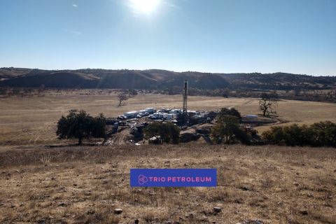
Trio Petroleum to Increase Monterey County Oil Production
2024-04-15 - Trio Petroleum’s HH-1 well in McCool Ranch and the HV-3A well in the Presidents Field collectively produce about 75 bbl/d.