1 Denver-based independent Key Production Co. Inc. has completed its #1-8 Lady Raiders test in an unnamed field three miles north of Colusa, Calif., flowing 1.6 million cu. ft. of gas a day through a 12/64-in. choke with 1,950 psi of flowing tubing pressure. The company perforated the well, in Section 8-16n-1w, Colusa County, from four Forbes zones between 4,319-83 ft. Total depth was 4,750 ft. and casing was set to 4,734 ft. 2 Trail Mountain Inc., an affiliate of Yates Petroleum Corp. of Artesia, N.M., has moved in a rig to drill the 8,500-ft. #1 Lucky Seven wildcat in Section 13-27n-51e in eastern Eureka County, Nev., about two miles southwest of Blackburn Field, according to IHS Energy. Blackburn Field has produced 5 million bbl. of oil and 16.5 million bbl. of water from the Indian Well, Chainman and Nevada formations since the field was opened in 1982. Trail Mountain also has proposed to drill the #1 White Dome wildcat in previously undrilled 10n-59e, some eight miles east of Currant, Nev. 3 EnCana Energy Resources Inc., Calgary, completed a wildcat in northern Montana for 1.2 million cu. ft. of gas per day from the Jurassic Sawtooth. The #9-25 Gutcher is about 18 miles northeast of Chester in Section 25-34n-7e, Liberty County. EnCana shut in the well after drilling to 3,415 ft., setting casing to 3,408 ft. and perforating Sawtooth between 3,222-28 ft. The nearest production is about four miles northwest in O'Briens Coulee Field, which produces gas from Cretaceous Bow Island above 2,100 ft. The nearest Sawtooth production is nine miles east in Rudyard Field in Hill County. EnCana has drilled three other wells in township 34n-7e but has not released details. 4 A substantial new play may be in the works as unconfirmed reports indicate initial production rates between 1,600 and 2,000 bbl. per day from the #1-18 Evaline wildcat, some 23 miles northwest of Wolf Point in eastern Valley County, Mont., says Rocky Mountain Oil Journal. Operator Continental Resources Inc., Enid, Okla., completed the wildcat in Lodgepole at a measured depth of 7,110 ft. in Section 18-30n-45e, even though the well was scheduled as a Mission Canyon (Madison) well proposed to 6,380 ft. A dry hole penetrated Lodgepole a mile south, but the only Lodgepole production in Montana is about 150 miles east on the Cedar Creek Anticline in Fallon County. 5 Amerada Hess Corp., New York City, completed a horizontal Madison development well in Beaver Lodge Field in southeastern Williams County, N.D., for 1,020 bbl. of oil, 3.5 million cu. ft. of gas and 1,840 bbl. of water a day. The #H-9H Beaver Lodge Madison Unit was drilled from a surface location in Section 1-155n-96w to a bottomhole location in Section 3. Beaver Lodge is North Dakota's oldest producing field with cumulative production since 1951 of 131.1 million bbl. of oil, 177.5 billion cu. ft. of gas and 88.7 million bbl. of water from Madison, Duperow, Silurian and Ordovician. The Nesson Anticline well was completed openhole in Madison from 8,245 ft. to 12,215 ft. A September 2000 horizontal well in the field about 0.75-mile north-northwest tested at 2,380 bbl. of oil, 2.2 million cu. ft of gas, and 2,243 bbl. of water per day but had pulled down to 252 bbl. of oil, 2.2 million cu. ft. of gas and 894 bbl. of water per day by last September, said IHS Energy. 6 Denver-based Anschutz Exploration Corp. completed a discovery in southwestern Wyoming's Overthrust Belt flowing 5.1 million cu. ft of gas and 681 bbl. of condensate a day from Nugget. The #10-24 Thief Creek produces from an openhole interval between 15,347 ft. and 16,268 ft. measured depth (14,232 ft. and 14,454 ft. true vertical depth). Anschutz tested the well through a 2.25-in. choke with flowing tubing pressure of 3,150 psi. The surface location is in Section 24-13n-121w, about 11 miles south of Evanston in Uinta County, about 1.5 miles from the Utah border. The bottomhole location is north-northwest in the same section. In 21 days during its first month online, the well produced 159.7 million cu. ft of gas, an average of 7.6 million cu. ft. a day. 7 Questar Exploration & Production Co., Salt Lake City, logged a discovery in its #15-20 Mesa flowing 4.5 million cu. ft. of gas, 36 bbl. of condensate and 24 bbl. of water a day from three fractured intervals in Mesaverde. The company gauged the Pinedale Anticline well, in Sublette County, Wyo., through an 18/64-in. choke with 2,400 psi of flowing casing pressure from a total depth of 14,240 ft. The well, drilled nine miles north of Pinedale in Section 20-32n-109w, produces from intervals between 12,626 ft. and 12,926 ft., 13,050 ft. and 13,208 ft., and 13,764 ft. and 14,040 ft. The company plans to add shallower Lance production later. 8 BP America Production Co. completed a discovery some 17 miles northwest of Wamsutter in Sweetwater County, Wyo., for 1.1 million cu. ft. of gas and one bbl. of condensate a day from Mesaverde. The Great Divide Basin #1-1 East Luman is in Section 1-22n-95w. BP tested the well between 11,228 ft. and 11,450 ft. through a 64/64-in. choke with 425 psi of casing pressure after drilling to a total depth of 11,503 ft. The discovery is 1,25 miles northeast of the opener for Stock Pond Field, which produces from the Almond member of the Mesaverde, according to an IHS Energy report. 9 Partners Pioneer Energy Resources Co., Dallas, and Flying J Oil and Gas Inc., North Salt Lake City, directionally drilled the #4-28 Monument Lake wildcat to 11,426 ft. in Section 28-21n-92w, Sweetwater County, Wyo. The well tested at 2.1 million cu. ft. of gas per day on a 22/64-in. choke from the Almond formation. Pioneer and Flying J, the operator, hold 10,650 acres in the area and plan a development program. In the same county, they drilled the #4-2 Wildrose, in Section 17n-94w, to 9,800 ft. and have set production casing. 10 BP America Production Co. tested 1.6 million cu. ft. of gas and 11 bbl. of condensate at its #29-2 NW Iron Pipe discovery, 28 miles southwest of Wamsutter in Sweetwater County, Wyo. It tested the well from two fractured Lewis zones and seven stimulated Mesaverde zones between 10,914 ft. and 12,046 ft., according to IHS Energy. The 12,118-ft. well is in Section 29-17n-97w, and BP has staked three more locations in the same area. 11 Devon SFS Operating Inc., Oklahoma City, tested 1 million cu. ft of gas, 15 bbl. of condensate and 23 bbl. of water a day from its #8-4-15-93 Flat Top discovery in Section 4-15n-93w in Carbon County, Wyo. The eastern Washakie Basin wildcat is about 25 miles south-southeast of Wamsutter. The well tested from fractured Mesaverde zones from 9,400 ft. to 9,635 ft. and from 9,710-28 ft. with a flowing casing pressure of 325 psi. The nearest Mesaverde producer is almost two miles east-southeast in Barrel Springs Field. 12 About 24 miles west of Craig, Colo., near the town of Maybell, Houston-based Ocean Energy Inc. has asked for a permit to drill the #1-16 Maybell, an 11,150-ft. wildcat in Section 15-7n-95w, Moffat County. The Axial Basin Uplift township has been drilled only a few times and has no production. Ocean plans to drill to Cretaceous Niobrara. The nearest production is some 11 miles northwest at Elm Ridge Resource Inc.'s #34-1 Tipperary-Nine-Mile-Hill discovery, completed last fall in Almond for 2 million cu. ft. of gas, 100 bbl. of condensate and 250 bbl. of water a day, says IHS Energy. 13 Tom Brown Inc., Denver, has a drilling permit for an 8,975-ft. wildcat some five miles south of Naturita, Colo., in the Paradox Basin. The #20-42 Maverick Draw-Federal is in Section 20-45n-15w, northern San Miguel County. It will test Cutler, Honaker Trail and Ismay formations. The nearest production is in Hamilton Creek Field, some 3.5 miles west-northwest, which produces gas from Honaker Trail and Hermosa between 6,500 ft. and 9,200 ft. 14 ConocoPhillips Alaska Inc. received permits for two wells on Alaska's North Slope. The #1 Puviaq is at a remote location south of Smith Bay some 65 miles southeast of Barrow in the National Petroleum Reserve-Alaska. The Puviaq prospect will be drilled from a location in Section 35-16n-10w, Umiat Meridian, and ConocoPhillips could drill two wells and two sidetracks from the same pad. When the company drills the well, it will be the farthest west well on the North Slope, except for some development drilling at Barrow gas field. The nearest production is 70 miles away. The other permit is for the #1 Oberon wildcat, in Section 9-10n-63w, Umiat Meridian, west of the Kuparuk River Unit. That location is some 10 miles east of Nuiqsut and eight miles west-northwest of Tarn Field.
Recommended Reading

Tech Trends: QYSEA’s Artificially Intelligent Underwater Additions
2024-02-13 - Using their AI underwater image filtering algorithm, the QYSEA AI Diver Tracking allows the FIFISH ROV to identify a diver's movements and conducts real-time automatic analysis.
Subsea Tieback Round-Up, 2026 and Beyond
2024-02-13 - The second in a two-part series, this report on subsea tiebacks looks at some of the projects around the world scheduled to come online in 2026 or later.
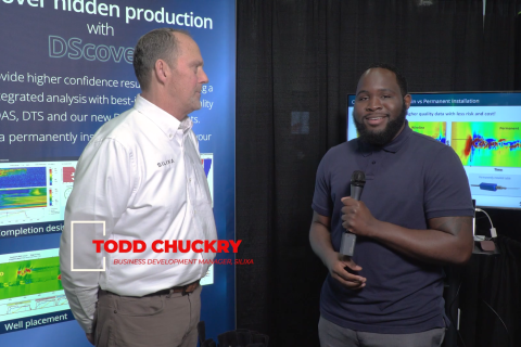
Exclusive: Silixa’s Distributed Fiber Optics Solutions for E&Ps
2024-03-19 - Todd Chuckry, business development manager for Silixa, highlights the company's DScover and Carina platforms to help oil and gas operators fully understand their fiber optics treatments from start to finish in this Hart Energy Exclusive.

CERAWeek: AI, Energy Industry Meet at Scary but Exciting Crossroads
2024-03-19 - From optimizing assets to enabling interoperability, digital technology works best through collaboration.

Cyber-informed Engineering Can Fortify OT Security
2024-03-12 - Ransomware is still a top threat in cybersecurity even as hacktivist attacks trend up, and the oil and gas sector must address both to maintain operational security.