Geochemical tools have been used to help locate oil and gas deposits since the industry's earliest years, and they still provide low-cost assessments that can reduce drilling risks. Today's surface methods are essentially refinements of the time-honored technique of drilling on or near oil seeps. The technique is based on the idea that minute amounts of hydrocarbons migrate to the surface through the bedding planes, joints and fractures in the rocks overlying oil and gas deposits, and that prospectors can use the presence or absence of these micro-seepages to fine-tune their drilling plans. Geochemical tools come in two major categories: direct tools, which measure hydrocarbons that have seeped upward from reservoirs, and indirect tools, which measure surface sediments for atypical patterns of alteration. Various alteration signatures are caused by degradation of the seeping hydrocarbons, either by bacteria or chemical action. Chromatography is the most popular direct technique, and measurements of fluorescence and ultraviolet properties are also used. Indirect techniques detect indications of microbial activity; alterations of surface sediments such as bleached redbeds and mineralized clays; the presence of minerals such as calcite, pyrite, uranium and various iron oxides and sulfides in the soils; the oxidation-reduction potential, acidity and conductivity of the soils; and, radiation profiles. Although some in the industry equate geochemistry with spurious "black box" techniques, the presence of surface geochemical anomalies overlying subsurface oil and gas fields has been demonstrated many times. Today's multicomponent seismic can also detect many of the alteration phenomena. Nonetheless, the mechanisms that allow micro-seepage are not well understood, and there are perplexing instances where some known fields do not produce surface anomalies in one or more methods. A further problem is the plethora of measurements in use. Often, the correct applications of geochemical methods are confusing. Serious practitioners of geochemical exploration continue to wage a strong campaign to introduce more scientific rigor into their field. Another issue is lack of research: only a few people are researching soil processes and the mechanics behind these processes. An accurate geochemical survey requires adequate sampling for the methods used, surveys that employ a number of methods, accurate interpretation of subsurface faults and features, and high sample quality. "With adequate sampling, geochemical surveys can define anomalies that delineate hydrocarbon seepage," says Jim Fausnaugh, owner of Denver-based geochemical consulting and analytical firm geotech.org. "The correct analytical method and proper interpretation will also help determine the validity of seepage anomalies." Smaller operators find geochemical analyses can stretch drilling budgets. They can also be valuable where seismic is difficult to obtain, extremely costly, or delivers vague results. Geochemical methods work particularly well at predicting dry holes. Studies have shown they can correctly predict commercial outcomes more than 50% of the time. Clearly, the best results from geochemical work come when it is used as a second-phase tool to help prove up anomalies generated by large-scale tools, says Fausnaugh. To select the methods that will deliver the best results, it's important to tailor the geochemical survey to the local geology and surface conditions. Geotech.org specializes in indirect methods, which he says are accurate, reproducible and quite affordable. A survey with a statistically relevant population might have thirty samples, which can be analyzed for a few hundred dollars. Worthington, Ohio-based operator Geopetro LLC says it uses geochemical exploration techniques because it has seen its usefulness on several occasions. "It is our opinion that under-sampling has been one of the most significant contributors to problems in the interpretation of geochemical surveys," says Geopetro's Paul Archer. Dallas firm HenSoil Inc. has also used geochemistry to determine the extent of possible hydrocarbon traps. The company, which has a geophysicist, geologist, engineer and landman, uses Landsat, radar, airborne micromagnetics, tellurics and seismic in addition to geochemistry in exploration, says Richard Smith, vice president of exploration. The company has production in Alabama and Mississippi and is working in the Trenton-Black River play in New York.
Recommended Reading
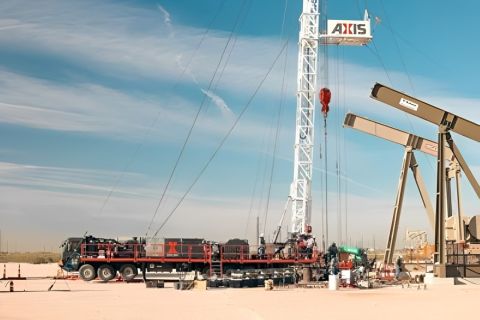
Axis Energy Deploys Fully Electric Well Service Rig
2024-03-13 - Axis Energy Services’ EPIC RIG has the ability to run on grid power for reduced emissions and increased fuel flexibility.

Oil States’ ACTIVEHub for Digitized Assets
2024-03-14 - Oil States Energy Services’ new ACTIVEHub system and ACTIVELatch help operators remotely monitor and automate frac locations for a more efficient and safer wellsite.

Tech Trends: AI Increasing Data Center Demand for Energy
2024-04-16 - In this month’s Tech Trends, new technologies equipped with artificial intelligence take the forefront, as they assist with safety and seismic fault detection. Also, independent contractor Stena Drilling begins upgrades for their Evolution drillship.
Defeating the ‘Four Horsemen’ of Flow Assurance
2024-04-18 - Service companies combine processes and techniques to mitigate the impact of paraffin, asphaltenes, hydrates and scale on production—and keep the cash flowing.

Quantum Capital’s View on AI: Lots of Benefits, Pain Points
2024-05-16 - The energy industry is lagging in the race to implement AI, but Sebastian Gass, CTO of Quantum Capital Group, offered a few solutions during Hart Energy’s 2024 SUPER DUG Conference & Expo.