1 United Oil & Minerals Inc., Austin, tested a discovery in Zapata County, Texas, flowing 2.3 million cu. ft. of gas and 418 bbl. of water per day on an 18/64-in. choke through perforations at 13,517-26 ft. The #1 Leroy Taylor was drilled in Anastacio Garcia Survey, A-151. IHS Energy Group notes the new producer is surrounded by shallow production in the inactive Joe Moss Field. 2 In Goliad County, Texas, a flow gauge of 2.443 million cu. ft. of gas, 118 bbl. of condensate and five bbl. of water per day were recorded by Allegro Investments Inc. at the #1 Signal Hill. The discovery yielded the flow on a 9/64-in. choke through perforations at 10,328-38 ft. The Victoria, Texas, firm's well is in Juan Fernandez Survey, A-21. 3 Newfield Exploration Co., Houston, is drilling below 10,830 ft. on the way to a target depth of 18,000 ft. at the #1 Eichhorn Gas Unit in M.A. Johnson Survey, A-259, Lavaca County, Texas. IHS Energy Group points out the deeper-pool venture is a few feet southeast of a Kemper East Field well that produced from Miocene at 1,872-78 ft., Eocene Yegua at 5,479-86 ft. and Oligocene Frio at 5,627-37 ft., and that gas production from 14,160 -15,646 ft. in Eocene Wilcox is found at a well nearly 1.75 miles northwest in Dry Hollow Field. 4 An offshore Jefferson County, Texas, discovery drilled by LLOG Exploration Offshore Inc. on High Island Block 251 flowed 6.247 million cu. ft. of gas per day at completion. The Metairie, La., independent's well-the #1 State Tract 25L-was tested through perforations at 10,023-96 ft. in Miocene. The closest production, also from Miocene, is nearly a mile north-northeast at the one-well High Island Block 90S Field. Meanwhile, onshore Jefferson County, a discovery was finaled by Houston-based Samedan Oil Corp. flowing 210 bbl. of oil and 190,000 cu. ft. of gas per day. Located in William Carroll Survey, A-13, Samedan's #1 Wilson Jr. High Unit was gauged on a 10/64-in. choke through perforations at 10,080-86 ft. The only log top reported is that of the Marginulina Howei, picked at 9,620 ft. 5 Fife Oil Co. Inc., Lafayette, La., recently reentered the temporarily abandoned #1 Mayard Heirs in Esther Field, Vermilion Parish, La., and, after testing for about 17 hr., the stabilized recovery was 3 million cu. ft. of gas, 29 bbl. of condensate and five bbl. of water per day on a 5/64-in. adjustable choke from the Planulina 1 Sand that previously had not produced in the field. Located in Section 7-14s-3e, the new-pay discovery was drilled to a measured total depth of 14,115 ft. Logs indicated the intended target Palnulina 3 Sand was depleted but the sand in the Planulina 1 zone at 13,000 ft. indicated potential. Perforations are at 12,991-97 ft. In addition to Fife, other partners in the well include Ereunao Drilling Partnership III LLC, Ereunao Oil & Gas Inc. and Diversified Energy Investments. 6 Houston independent Swift Energy Co. reports it encountered approximately 340 ft. of net pay as indicated by log analysis at the #187 CM, Section 13-20s-26e, and apparently found a new pay for Lake Washington Field in Plaquemines Parish, La. Swift owns a 100% working interest in this-the sixth well of a 20-well development program planned for this year in the field. The #187 CM was drilled to a total depth of 6,158 ft. and intersected three different hydrocarbon-bearing sands, including one of the F-series sands, a horizon that has not previously produced in the field. 7 Amerada Hess Corp., New York City, has completed its second producer on Breton Sound Block 51 in Louisiana state waters offshore Plaquemines Parish, having gauged a flow of 350 bbl. of oil and 600,000 cu. ft. of gas per day on an adjustable choke at the #1 State Lease 17245. IHS Energy Group reports Miocene was tested through perforations at 11,438-54 ft. A half-mile northeast, the company's initial producer on the block-the #1 State Lease 16890-was completed last fall flowing 494 bbl. of oil and 1.81 million cu. ft. of gas per day on a 9/64-in. choke from Cibicides carstensi, perforated at 11,369-11,412 ft. 8 In Louisiana's East Lake Arthur Field, The Meridian Resource Corp., Houston, is drilling below 13,000 ft. with an objective depth of approximately 19,000 ft. at the #2 Hughes in Section 37-10s-3w, Jefferson Davis Parish. Meridian notes the new test is a replacement for the #1 Hughes that experienced cementing problems during the completion phase and was subsequently abandoned. During the drilling of the #1 Hughes, Meridian logged an apparent 100 ft. of net pay in the Bol Mex 3-6 sands. The company owns a 96% working interest and a 68% net revenue interest in the field. 9 In the Gulf of Mexico, Samedan Oil Corp.'s Slammer discovery on Mississippi Canyon Block 849 encountered 140 ft. of pay in five main sands while being drilled to a total depth of 16,227 ft., according to interest-owner Spinnaker Exploration Co. LLC, Houston. Operations have been suspended at the #1 OCS-G-21188, which sits in 3,575 ft. of water. Spinnaker owns a 34% working interest in the tract. Production in Mars Field is about five miles northeast. 10 IHS Energy Group reports Nexen Inc. has entered into an agreement with Shell Exploration & Production Co. to jointly explore a 1,044-square-mile area of the Gulf of Mexico for gas in Miocene reservoirs. The area of mutual interest outlined in the agreement is made up of 116 blocks in the Ship Shoal and South Timbalier areas. Within this area, Nexen has the right to earn a 40% working interest in any acreage acquired by Shell, and Shell has the right to earn a 60% interest in any acreage acquired by Nexen. The first test drilled under the agreement will be the #1 OCS-G-22754 on South Timbalier Block 239. The test, scheduled to be started soon and projected to 22,500 ft., is on the Fergana Prospect on blocks 239 and 248. 11 Devon Energy Corp., Oklahoma City, has announced an apparent discovery on the Cascade Prospect on Walker Ridge Block 206 in approximately 8,200 ft. of water. Drilled to a total depth of 27,929 ft., the BHP Petroleum (GOM) Inc.-operated #1 OCS-G-16965 encountered a potentially significant hydrocarbon-bearing column. Devon says an appraisal test could be drilled later this year following analysis of core samples and other available information. Devon holds a 25% working interest in the Cascade Prospect, BHP has 50% and Petrobras holds the remaining 25%. 12 Houston-based EEX Corp. reports on an oil discovery made on its Devil's Island Prospect on Garden Banks Block 344. Amerada Hess Corp., the operator, drilled the #4 OCS-G-8232 to a total depth of 24,525 ft. in about 2,300 ft. of water, encountering more than 100 ft. of net oil pay in a single, high quality reservoir. The well was drilled by Amerada Hess pursuant to a farmout agreement. EEX has a 20% working interest in the discovery and Amerada Hess has 80%. In addition, EEX and Amerada Hess have agreed to commence an updip sidetrack of this well to further appraise the discovery. Under the agreement, EEX will bear the first $4.5 million of the sidetrack cost and Amerada will bear the remaining cost until a limit of $9 million has been reached. Any expenditure above $9 million will be paid 20% by EEX. Separately, EEX has entered into an asset purchase, farmout and joint exploration agreement with BP Exploration & Production Inc. BP acquired 75% of EEX's current interest in 23 outer continental shelf (OCS) leases. As part of this agreement, BP will conduct further leasing and geophysical activities in an area encompassing 140 OCS blocks. At the end of the initial evaluation period, BP may elect to commit to the drilling of up to three tests. EEX will be carried for its 25% interest of the costs of the initial evaluation period as well as the drilling of the first three exploration tests. 13 Mississippi's Warren County has seen a discovery made at the Sklar Exploration Co. LLC #1 Feld Heirs, where the flow gauge at completion was 332 bbl. of oil, 251,000 cu. ft. of gas and 29 bbl. of water per day through a 19/64-in. choke. The Southeastern Oil Review reports data filed with the State Oil & Gas Board shows production is from overall perforations in upper zone between 12,142-12,819 ft. and lower zone between 13,416-16,612 ft. The producing reservoirs were listed as Cretaceous Mooringsport, Ferry Lake, Rodessa, Sligo and Hosston, and Jurassic Cotton Valley. The Shreveport firm's discovery, in Section 40-17n-4e, has been named South Kings Dome Field.
Recommended Reading

Tech Trends: QYSEA’s Artificially Intelligent Underwater Additions
2024-02-13 - Using their AI underwater image filtering algorithm, the QYSEA AI Diver Tracking allows the FIFISH ROV to identify a diver's movements and conducts real-time automatic analysis.
Subsea Tieback Round-Up, 2026 and Beyond
2024-02-13 - The second in a two-part series, this report on subsea tiebacks looks at some of the projects around the world scheduled to come online in 2026 or later.
Exclusive: Silixa’s Distributed Fiber Optics Solutions for E&Ps
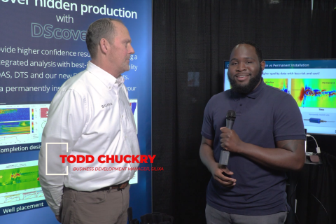
2024-03-19 - Todd Chuckry, business development manager for Silixa, highlights the company's DScover and Carina platforms to help oil and gas operators fully understand their fiber optics treatments from start to finish in this Hart Energy Exclusive.

CERAWeek: AI, Energy Industry Meet at Scary but Exciting Crossroads
2024-03-19 - From optimizing assets to enabling interoperability, digital technology works best through collaboration.

Cyber-informed Engineering Can Fortify OT Security
2024-03-12 - Ransomware is still a top threat in cybersecurity even as hacktivist attacks trend up, and the oil and gas sector must address both to maintain operational security.