1 Anadarko Petroleum Corp., Houston, is drilling near the border between the east and central Gulf of Mexico in an aggressive wildcat program. It has permitted the first wildcat in the deepwater Lloyd area in Block 360 in the eastern Gulf. The #1-OCS-G-23479 will be in 9,098 ft. of water and will be the first of 18 wells proposed in a four-block area, which also includes Lloyd 315, 316 and 359. Anadarko posted more than $29.1 million in bids for the four blocks in the December 2001 lease sale. The company previously had filed an exploration plan for Lloyd blocks 5, 6, 49 and 50. In separate action the company permitted its Jubilee West prospect in Atwater Valley 349 on the border between Atwater Valley and Lloyd. The #1 OCS-G-18577 will be drilled in 8,841 ft. of water as the first of 10 wells proposed for blocks 349 and 305 immediately north. 2 Centurion Resources LLC, Fulton, Miss., reached total depth at 1,500 ft. and the operator has set pipe at its #1 Leon Johnson 23-10 wildcat in nonproducing Tishomingo County, Miss., according to IHS Energy. The well is in Section 23-2s-10e. Fifteen wells have been drilled in the county with no production. The nearest previous drilling that reached hydrocarbons was six miles south-southwest in Section 18-5s-11e, where the #1 G.L. Hardin was drilled and abandoned after recovering an unreported amount of gas. 3 Palmer Petroleum Inc., Shreveport, completed two substantial producers from the Frisco City formation at its Monroeville North Field in Monroe County, Ala. The #1 Williams 1-5 sidetrack in Section 2-6n-7e flowed 485 bbl. of oil and 36,000 cu. ft. of gas a day from perforations between 11,376-90 ft. through a 9/64-in. choke with 1,135 psi of flowing tubing pressure. The company's #1 Williams 1-4 flowed 406 bbl. of oil and 34,000 cu. ft. of gas in the same section from perforations between 11,788-95 ft. The company also permitted the 11,100-ft. #1 Walter C. Odom 34-7, a stepout from Monroeville North Field in Section 34-7n-7e, more than a mile northwest of the Williams wells. That well also will test Frisco City. 4 Pruet Production Co., Jackson, Miss., is drilling an exploratory test in southern Monroe County, Ala. If successful, the well would reestablish production from Vocation South Field. The #1 Container Corp. 34-9 is in Section 34-4n-6e, and will drill to Norphlet at 14,600 ft. A quarter-mile southwest, the only well in Vocation South Field was completed flowing 547,000 cu. ft. of gas and 190 bbl. of condensate a day from Smackover between 13,948 and 14,000 ft. and pumping 1.1 million cu. ft. of gas and 565 bbl. of condensate per day. 5 Niagaran reef is the target for an exploratory test by Jordan Development Co. LLC, Traverse City, about 12 miles northwest of Grayling in Crawford County, Mich. The company has permitted the #4-31 Croft in Section 31-38n-4w, Frederic Township, to evaluate Brown Niagaran gas potential in an area dominated by shallow Antrim production in Crawford County-Antrim Field. The nearest Niagaran production is 1.5 miles north where the Blue Lake 24-28n-5w Field discovery well tested 1 million cu. ft. of gas and 95 bbl. of condensate a day. 6 Savoy Energy LP, Traverse City, has permitted the #1-8 PDC wildcat to 7,061 ft. to test Clinton shale in Alcona County, Mich. The well is in Section 8-28n-8e, Caledonia Township, a mile east of Hubbard Lake Field, which produces from Clinton. 7 Glen R. Duke, Rushville, Ind., has permitted the #1 Duke, a wildcat projected to Trenton at 900 ft. in Section 13-13n-8e in Rush County, Ind. The well is 2.5 miles northwest of Trenton Field, which produces from the Trenton lime, and 9.5 miles southwest of Rushville. 8 Resource & Energy Technologies Co., Bardstown, Ky., plans two wildcat wells, both in Edmonson County, Ky. The #3 Mollie Kersey will go to Corniferous at 1,500 ft. in Section 12-H-40e, Smiths Grove Quad. The well is less than 1.5 miles south of Silent Grove Church South, a Warsaw formation field, and more than five miles north of the town of Smiths Grove. The second wildcat is the #2 Royce Houchin, planned to reach the Laurel at 1,500 ft. in section 20-H-40e, Smiths Grove Quad. That well is slightly more than two miles north of Rock Hill West (Corniferous) Field and about the same distance from Smiths Grove as the Mollie Kersey well. 9 D.T. Atha Inc., Sugar Grove, Ohio, plans three wildcats in Marion County in north-central Ohio, all within five miles north and northeast of La Rue, and all permitted to penetrate Trenton, Black River and Trempealeau to depths of 1,999 ft. The wells are the #1 Field in Section 17, Montgomery Township, La Rue Quad; the #1 Mattix Unit in Section 35, Grand Township, Meeker Quad, and the #1 Harder Unit, Section 9, Montgomery Township, Meeker Quad. The wells are 3.5 to four miles south and southeast of a single Trenton oil discovery made by Mar Oil Co. last year. Mar's #1 Roszman in Section 29, Grand Township, Marseilles Quad, went to 1,982 ft. in Trempealeau and tested 35 bbl. of oil and 80,000 cu. ft. of gas a day from the Trenton formation. Zorin Exploration Ltd., Calgary, Alberta, parent of Mar, said the well reached a completely dolomitized 62-ft. section of Trenton with an average porosity of 10% and a maximum porosity of 22%. 10 Fairman Drilling, Dubois, Pa., claimed a discovery with its #1 Learn new-field well in Schuyler County, N.Y. The well tested 84,000 cu. ft. of gas a day from a commingled Trenton-Black River interval between 8,390 and 8,576 ft. after reaching a total depth of 9,061 ft. and after an acid frac. The field is in Section E, Montour Falls Quad, Montour Township, less than a quarter-mile south of Odessa, N.Y. 11 Triana Energy Inc., Charleston, W.Va., will look for hydrocarbons in the Trenton-Black River with its #1 Linder well, scheduled to 12,100 ft. in Tioga County, Pa. The well is three miles south of Elkland in Farmington Township, Elkland Quad. It's about 2.5 miles northwest of the 70-year-old Tioga West Field, which produces gas from the Oriskany formation above 5,000 ft. There is no deep drilling in the area. 12 Mid East Oil Co., Indiana, Pa., reported a series of high-volume gas completions in its Council Run Field on state game commission land in Centre County, Pa. Among the 13 wells, Mid East reported abandoned locations at the #19 Litke, #21 Litke and #23 Litke, all in Section B, Snow Shoe Quad, Burnside Township. The other wells fared better in the Upper Devonian at around 5,000 ft. In the same general area, the #74 State Game Lands No. 100 tested at 1.4 million cu. ft. of gas a day; the #76 State Game Lands No. 100, 2.6 million; the #25 Litke, 6.6 million; the #26 Litke, 105,000; the #29 Litke, 900,000; the #34 Litke, 4.1 million; the #7 Foresman, 817,000; the #35 Litke, 2.4 million; the #36 Litke, 1.4 million; and the #41 Litke, 1.8 million. 13 Columbia Natural Resources Inc., Charleston, W.Va., staked a wildcat well to test the Lower Silurian Tuscarora at 6,878 ft. in central Kanawha County, W.Va. The #824214 W.D. Lewis Heirs LP well is within the Coal Fork town limits, just east of Charleston, in Malden District, Charleston East Quad. The operator is drilling in an area in which most wells have been to depths shallower than 5,200 ft., and much of that drilling was carried out in the mid- to late 1930s, according to IHS Energy. 14 Target Oil & Gas Inc., Danville, Ky., staked two wildcats in Lawrence County, Ky. Both are projected to the Devonian and both to a depth of 3,000 ft. The company's Big Sandy #1 Don Howard is in Richardson Quad, 1.1 miles south of Beech Farm (Devonian) Field and 10.2 miles south of Louisa. The Big Sandy #2 Don Howard is in the same quad, 1.3 miles northeast of Big Sandy Field and 10.4 miles south of Louisa. 15 Daugherty Petroleum Inc., Lexington, Ky., has scheduled an unnamed field well and a wildcat in Bell County, Ky., west of Pineville. Both are aimed at Clinton Shale at 4,000 ft. The company's #1 Billy Ray Carroll is in Kayjay Quad, a mile east of an unnamed field and 7.25 miles west of Pineville. The #1 Ernest Slusher et al. unit wildcat is in Artemus Quad, two miles south of Artemus-Himyar (Corniferous) Field and five miles west of Pineville. 16 Equitable Production Co., Charleston, W.Va., plans a wildcat to 5,756 ft. to test Devonian in Lee County, Va. The #V-505273 Slemp Campbell is in Yokum District, Keokee Quad, nearly 6.5 miles south of Lynch, Ky. The nearest production is three miles east-northeast in Roaring Fork (Big Lime) Field. 17 Young Oil Co., Knoblick, Ky., has production of 120 bbl. of oil per day at its Ralph Dishman #8-Y well, drilled to the Stones River Formation at 1,260 ft. The well is in Section 24-1s-52e, Alpine Quad, about five miles north of Livingston in Overton County, Tenn. It is the fifth well in the field. The other wells were completed at 850 ft. to 1,000 ft.
Recommended Reading

TGS Starts Up Multiclient Wind, Metaocean North Sea Campaign
2024-05-07 - TGS is utilizing two laser imaging and ranging buoys to receive detailed wind measurements and metaocean data, with the goal of supporting decision-making in wind lease rounds in the German Bright.
Exclusive: Silixa’s Distributed Fiber Optics Solutions for E&Ps
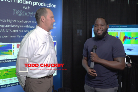
2024-03-19 - Todd Chuckry, business development manager for Silixa, highlights the company's DScover and Carina platforms to help oil and gas operators fully understand their fiber optics treatments from start to finish in this Hart Energy Exclusive.

CERAWeek: AI, Energy Industry Meet at Scary but Exciting Crossroads
2024-03-19 - From optimizing assets to enabling interoperability, digital technology works best through collaboration.

Cyber-informed Engineering Can Fortify OT Security
2024-03-12 - Ransomware is still a top threat in cybersecurity even as hacktivist attacks trend up, and the oil and gas sector must address both to maintain operational security.
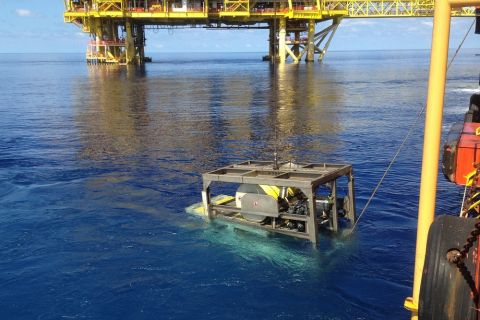
Forum Energy Signs MOU to Develop Electric ROV Thrusters
2024-03-13 - The electric thrusters for ROV systems will undergo extensive tests by Forum Energy Technologies and SAFEEN Survey & Subsea Services.