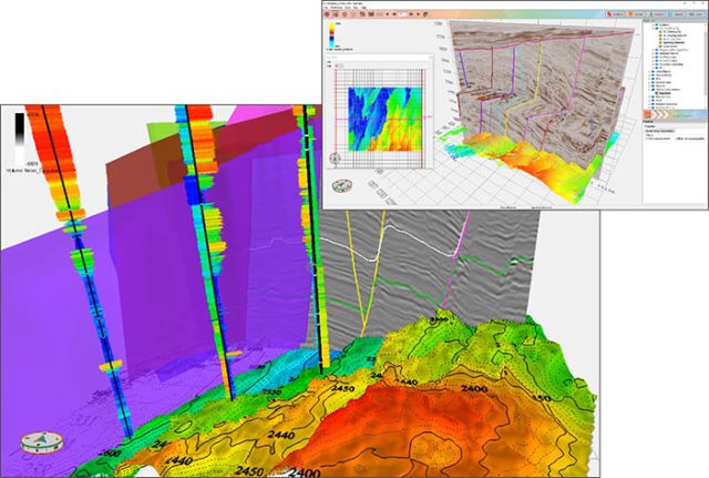
The patent-pending Adaptive Horizon tool is one in a trinity of technologies that comprises GeoTeric’s Adaptive Interpretation System. (Image courtesy of GeoTeric)
In an industry where the axiom “time is money” applies more than ever before, it is perhaps surprising that extremely skilled and highly paid professionals need to rely on software, the operation of which absorbs more of their time than consideration of the results they need to produce. However, that is the situation the E&P industry faces, at least when it comes to many of the geological and geophysical software applications that underpin the subsurface workflow.
Arguably, the biggest issue that the industry faces when it comes to understanding the subsurface is not a lack of data or shortcomings in theoretical understanding but the large and growing gap between what is possible and what is actually done in practice.
A new approach to software development called Cognitive Interpretation can resolve this issue. Rather than dumbing down, Cognitive Interpretation recognizes the central role of geoscientists in interpretation and is focused on empowering them to use their knowledge and experience as effectively as possible.
In June 2017 GeoTeric will release interpretation technology intended to redefine interpretation to get the most coherent and thorough understanding of the subsurface from seismic and well data. The Adaptive Horizon technology enables the simultaneous interpretation of seismic, multiattribute volume combinations and color blends with preview-driven editing. This unique (and fun to use) interpretation tool allows the user to integrate all resulting components of attribute and color blend analysis, ensuring an advanced geological understanding prior to any interpretation. The patent-pending Adaptive Horizon tool is one in a trinity of technologies that comprises GeoTeric’s Adaptive Interpretation System, further complimented by the Adaptive Geobodies and the Adaptive Faults solutions. Working together, the Adaptive Interpretation System enables a watertight structural framework to be built, forming the basis of the geological model.
Complementing the interpretation workflow, GeoTeric has introduced well correlation capabilities, petrophysical interpretation tools and seismic-to-well-tie functionality to complete the geological and geophysical interpretation toolkit. The increased functionality in the release of GeoTeric 2017.1 provides users the ability to get more from their data with less requirement for third-party applications. With GeoTeric 2017.1 users will be able to interpret the components required for a geological model based on a more comprehensive understanding of the geology revealed within the seismic and well data.
This powerful functionality will be embedded in the base level Interpret Module of GeoTeric and will therefore be available to every GeoTeric user.
Recommended Reading
Guyana’s Stabroek Boosts Production as Chevron Watches, Waits
2024-04-25 - Chevron Corp.’s planned $53 billion acquisition of Hess Corp. could potentially close in 2025, but in the meantime, the California-based energy giant is in a “read only” mode as an Exxon Mobil-led consortium boosts Guyana production.
US Interior Department Releases Offshore Wind Lease Schedule
2024-04-24 - The U.S. Interior Department’s schedule includes up to a dozen lease sales through 2028 for offshore wind, compared to three for oil and gas lease sales through 2029.
Utah’s Ute Tribe Demands FTC Allow XCL-Altamont Deal
2024-04-24 - More than 90% of the Utah Ute tribe’s income is from energy development on its 4.5-million-acre reservation and the tribe says XCL Resources’ bid to buy Altamont Energy shouldn’t be blocked.
Mexico Presidential Hopeful Sheinbaum Emphasizes Energy Sovereignty
2024-04-24 - Claudia Sheinbaum, vying to becoming Mexico’s next president this summer, says she isn’t in favor of an absolute privatization of the energy sector but she isn’t against private investments either.
Venture Global Gets FERC Nod to Process Gas for LNG
2024-04-23 - Venture Global’s massive export terminal will change natural gas flows across the Gulf of Mexico but its Plaquemines LNG export terminal may still be years away from delivering LNG to long-term customers.


