Presented by:
![]()
This article appears in the E&P newsletter. Subscribe to the E&P newsletter here.
Bell Geospace recently installed the new GTz Gravimeter on the same long-range aircraft as their Full Tensor Gravity Gradiometer (FTG) technology. This is the first-time gravimetry and gradiometry technologies of this calibre have been paired on the same vessel. The new offering, FTG GTZ, is high-resolution data, collected with consistent, continuous parameters. These data continuity produce a refined geological map and become extremely valuable during data integration stages of the geoscience workflow.
In this article, Bell Geospace shares sample data from a recent FTG GTZ survey and considers the applications of this latest advancement in airborne gravity gradiometry technology.
Gradiometry vs Gravity (a recap)
You will already know that gravity is the force between two masses (Newton). Measuring gravity for geophysical purposes determines the density, volume, and depth of different geological bodies in the subsurface. The term scalar gravity is used to describe what is commonly known as gravity and distinguishes gravimetry from gravity gradiometry.
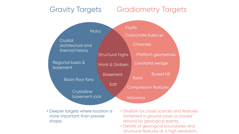
Gravimetry and gravity gradiometry offer different advantages to exploration.
- Gravimetry measures the vertical component of the Earth's gravity field as a scalar quantity (a magnitude described by a single number). The instrument to measure this is called a gravimeter.
whereas
- Gradiometry measures the spatial rate of change in the gravity field as a vector quantity (both as magnitude and direction). The instrument to measure this is called a gradiometer.
A gradient signal decreases with the cube of the distance from the target, whereas a scalar gravity signal decreases with the square of the distance. In a practical sense what this means in terms of geological targeting is displayed as Figure 1.
Gradiometry with Gravity
Gravimeters have been onboard Bell Geo’s Basler BT-67 aircraft since 2008. Pairing the FTG and gravimetry technology together has been successful across hundreds of thousands of line kilometres of airborne data all over the world with particularly advantageous results in areas of uneven terrain or crystalline basement rock. However, for Operators looking for options in transition zones or deep-water settings, the FTG GTZ offers a brand-new perspective. This is because
1. The GTz is an industry-leading standalone top quality gravimetry product.
Until Transparent Earth Geophysics (formerly CMG Operations) overcame the engineering challenges it has never been viable to add a gravimeter with these specifications to a data acquisition plane designed for gradiometry surveys. The GTZ gravimeter is now onboard Bell Geo’s Basler BT-67 aircraft, running successfully alongside the existing FTG equipment and on acquisition duties in Indonesia.
2. Airborne acquisition overcomes many of the challenges associated with typical data collection in transition zones from land to shallow water to deep water.
Continuous data can be provided for a complete geological map. It can be challenging and is expensive to acquire continuous seismic in the transition zone environment because switching between different methods (dynamite to airgun to nodes) can result in gaps in the data. Source and receiver intervals vary a lot between land and sea.
Airborne acquisition provides a cost effective and passive alternative to acquiring seismic in the shallow water. A plane flying at 80 to 100 m above the ground, acquiring data passively, has less impact on marine life than seismic activities.
Cost savings are also delivered due to a relatively capsule-sized crew. Three to seven people (who only travel between the hotel and the airport), can operate, and delineate a 10,000 square km area to 300-m resolution in one month. Even during a pandemic. Permits typically take 30 to 60 days and data processing can be done in two to three weeks.
3. The combination of FTG GTZ together with the Magnetometer (also already onboard) provides full spectrum, high resolution data for regional scale exploration.
Common applications include mapping faults and structures, basement, thrust folds, carbonates or salt for accurate 3D geological modeling. Other valuable use cases include creating improved velocity models and detecting shallow hazards.
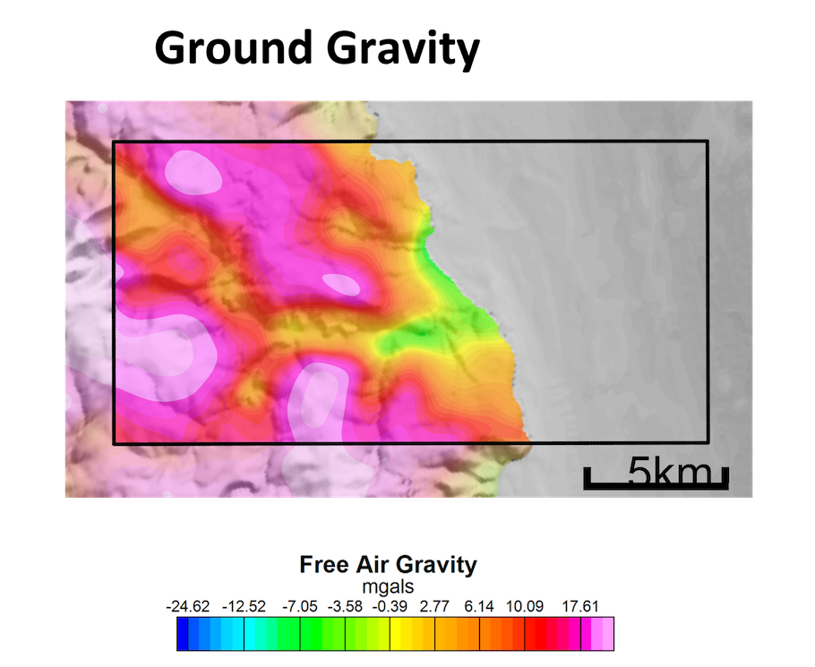
Example data
This article shares the test flight case study data by means of demonstrating how FTG GTZ is comparable to a ground gravity survey.
Data Comparison of Ground Gravity, GTZ Gravity and FTG GTZ