
(Source: Shutterstock.com)
The flying devices that were once used only for military purposes are permeating numerous operations of the oil and gas industry. Unmanned aerial systems (UAS), also known as drones, are offering industry-tailored solutions to oil companies with the capability to gather data in difficult-to-reach and dangerous environments. However, with great data comes great responsibility. Progress in drone technologies and their increasing deployment in industry processes have given rise to an important concern—making sense of the data to streamline the decision-making process. Therefore, it is important for companies to assess the data analytics tools, cybersecurity threats and flight risks while developing their UAS program.
Inspection programs
Traditional asset inspection methods are costly, time-intensive and dangerous, often requiring production shutdowns. The development of UAS technologies and data analysis software programs have progressed remarkably, paving the way for efficiency in the process of asset management. Companies also use drones to capture images of oil wells and offshore rigs throughout the initial drilling process. Once the well begins operating, drones safely and efficiently monitor operations, including routine inspections of active drilling rigs and flare stacks.
“Unmanned systems have improved efficiency across all phases of the industry operations,” Barrett Walker, program manager of small UAS at Cheniere Energy, told E&P. “[Drones] allow operators to perform inspections much more easily, which has afforded companies the opportunity to increase the speed and frequency of inspections. These faster and more frequent inspections have enabled companies to be extremely proactive in the identification and resolution of issues that were once limited or even unavailable,” he said.
In addition to flexible and cost-effective methods of asset inspection, drones provide a data-intensive structure for tracking conditions over time because drones offer a consistent collection process. “Compared to traditional methods such as helicopter pilots, a drone can be preprogrammed to run the exact same navigation points and route at the exact same height with better ROI [return on investment] and ability to map changes over time. By incorporating a drone-based program, oil and gas companies can comply with government regulations while improving the entire asset management cycle,” said Dave Culler, general manager of energy at Precision Hawk.
He added that beyond visual line of sight (BVLOS) drone inspections have been enticing the industry since the U.S. Federal Aviation Administration first authorized a BVLOS flight during BP’s Prudhoe Bay Alaska operation in 2014. A recent whitepaper from Skylogic Research showed that oil companies using drones can reduce well pad inspection costs by approximately 66%, from $80 to $90 per well pad to $45 to $60 per pad. “These savings will only increase once BVLOS operations are further incorporated into drone inspection programs,” Culler said.
One of the key operational benefits of using drones for inspecting energy assets is safety. For an oil and gas firm, asset management requires regular inspections that often come with inherent risks. “Driving trucks can be hazardous due to lease roads that develop potholes and washed-out areas, thanks to inclement weather. While performing routine inspections and maintenance, such as walking a pipeline or checking well pad equipment, field workers frequently encounter hazards related to their sheer proximity to the equipment,” Culler said. He added that inspections using manned aircraft, such as helicopters, can cost up to $1,250 per rotor hour.
Data analytics
Although unmanned systems have the ability to acquire vast amounts of data, their full potential is realized only when data analytics tools are used to analyze captured images and convert them into timely, precise and actionable information.
To process data collected via drones, analysts at energy companies need to apply machine vision-powered mapping and modeling algorithms to improve the accuracy of their asset inventory and surface issues before they cause critical failures. “Using applied machine intelligence, the raw, unstructured data can be converted to integrated data delivered directly to their systems of record. This reduces the need for hours of image review and cuts back on data overload to create a more focused reporting system, thus improving the accuracy and repeatability of asset inspections,” Culler said.
Supporting technologies, such as artificial intelligence (AI), analytics, robotics, Internet of Things and cloud systems, allow companies to access and process the data to make better data-driven decisions, according to Xinbo Xhang, marketing director of Industrial Skyworks. Using these tools, analysis of data collected from oil rigs, offshore platforms and other areas provide valuable information that companies can use to improve operations, production and efficiency as well as the ability to forecast and address breakdowns.
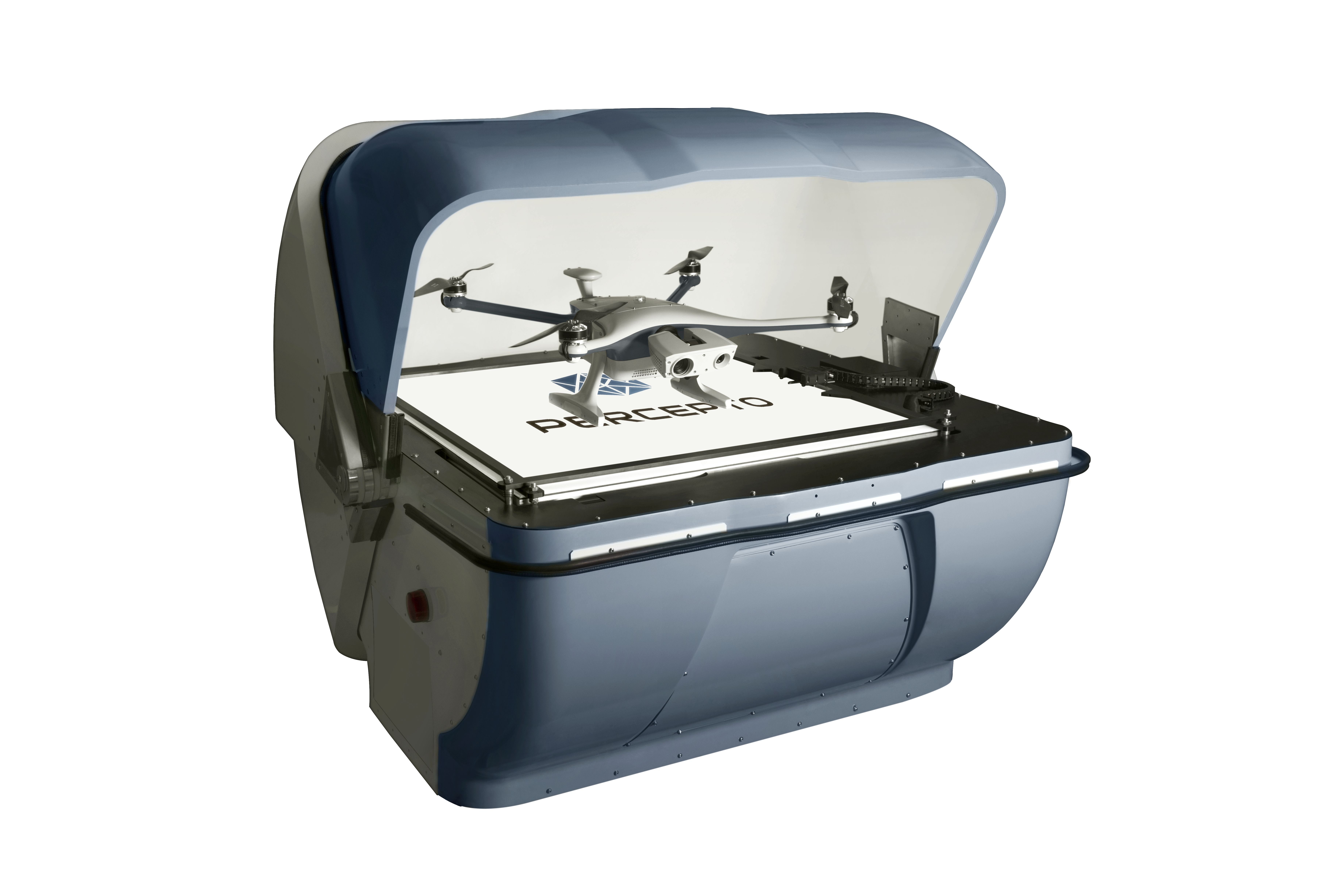
Percepto recently launched its drone-in-a-box autonomous solution, which operates without human intervention, automatically takes off from its base station, performs prescheduled tasks, and returns to charge and transfer data to cloud storage upon completion of the mission. “The solution enables strategic data collection and application of machine learning and AI to the data in order to provide insights for different stakeholders of the company,” said Illy Gruber, vice president of marketing at Percepto. The drone system uses the PerceptoCore software suite for flight management, data storage, report management, permissioned team access, and computer vision and AI-powered applications.
Risk management
Earlier this year, the American Petroleum Institute (API) published a guide to help oil and gas companies establish a framework for using drone technology. API suggested that companies should consider producing a flight risk assessment tool to differentiate between low and high-risk flights, establish appropriate approval processes and implement risk mitigation strategies.
The document also identifies cyber and physical security as areas of great concern with federal regulations attempting to keep pace with the growing UAS industry.
According to the guide, UAS service providers possess necessary skills to operate drones for data collection, but they may not have knowledge of the oil and gas industry to interpret and analyze the data for their clients. Therefore, it is critical for companies to consider the subject matter expertise they may need for successful operations and how to integrate those resources with the UAS program.
The usage of drones for data collection in the energy industry provides benefits to the company but also has risks such as cybersecurity and safety associated to the process, according to Chris Hewlett, specialist leader of U.S. Drone Services at Deloitte Consulting. He added that it’s also critical that these systems must not interfere with airspace where manned aircraft may be flying or endanger people on the ground.
Deloitte released a playbook to help companies de-risk operations and maximize the benefi ts of using UAS. Companies can avoid flight risks by timely assessment, crisis management and modeling. “[Deloitte] is focusing on ensuring that the data acquisition process follows a methodology. Also, it’s important to figure out a human-in-the-loop process so as not to rely entirely on an artificial intelligence system. This will enable oil companies to maximize returns and minimize risk,” Hewlett said.
Recommended Reading
US Drillers Cut Oil, Gas Rigs for Fifth Week in Six, Baker Hughes Says
2024-09-20 - U.S. energy firms this week resumed cutting the number of oil and natural gas rigs after adding rigs last week.

Western Haynesville Wildcats’ Output Up as Comstock Loosens Chokes
2024-09-19 - Comstock Resources reported this summer that it is gaining a better understanding of the formations’ pressure regime and how best to produce its “Waynesville” wells.

August Well Permits Rebound in August, led by the Permian Basin
2024-09-18 - Analysis by Evercore ISI shows approved well permits in the Permian Basin, Marcellus and Eagle Ford shales and the Bakken were up month-over-month and compared to 2023.

Kolibri Global Drills First Three SCOOP Wells in Tishomingo Field
2024-09-18 - Kolibri Global Energy reported drilling the three wells in an average 14 days, beating its estimated 20-day drilling schedule.
Permian Resources Closes $820MM Bolt-on of Oxy’s Delaware Assets
2024-09-17 - The Permian Resources acquisition includes about 29,500 net acres, 9,900 net royalty acres and average production of 15,000 boe/d from Occidental Petroleum’s assets in Reeves County, Texas.
Comments
Add new comment
This conversation is moderated according to Hart Energy community rules. Please read the rules before joining the discussion. If you’re experiencing any technical problems, please contact our customer care team.