Presented by:
![]()
This article appears in the E&P newsletter. Subscribe to the E&P newsletter here.
New leaseholders in the U.S. Gulf of Mexico could be looking to understand the base salts of new acreage using existing full tensor gravity gradiometry data as a tool for accurate modelling.
The U.S. Bureau of Ocean Energy Management (BOEM) U.S. Gulf of Mexico Lease Sale 257 completed on Nov.17. The auction generated nearly $192 million in high bids placed on 307 blocks and that a total of 33 companies participated in Sale 257.
The Gulf of Mexico Outer Continental Shelf (OCS) spans around 160 million acres. It is reported by BOEM that this acreage is projected to contain nearly 48 billion barrels of undiscovered technically recoverable oil along with 141 trillion cubic feet of undiscovered technically recoverable gas. However, one of the technical challenges in the Gulf of Mexico is modeling salt.
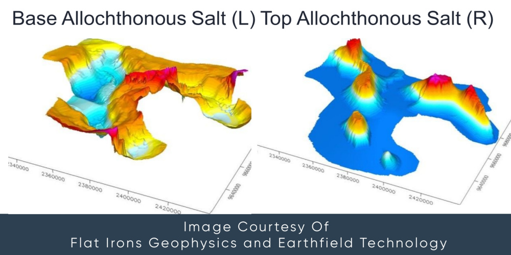
Traditionally, building a salt model can take many months. With potential fields data, a three-dimensional salt model will usually take just a few weeks. This type of model allows operators to capture both the top autochthonous and base allochthonous salt (Figure One).
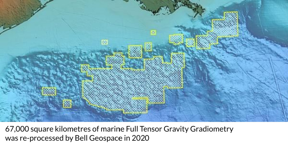
Bell Geospace has 67,000 sq km of existing and available full tensor gravity gradiometry (FTG) potential fields data in the Gulf of Mexico (Figure Two) and the company reprocessed this data in 2020.
One of the prime uses for FTG data is that it can be used for modeling base salt as well as being used for velocity models surrounding the salt.
This article discusses a brief case study to demonstrate the modeling concept in action. In this specific example, two companies had seismic over the same area of salt in the Gulf of Mexico.
The bottom of the allochthonous salt body was clearly depicted on one section of the seismic, but could not be clearly determined in other sections. This older seismic was therefore problematic for the two companies.
One company drilled through their salt where there was a clear end. The second company decided to use the seismic to make an informed guess about where the salt bottom might be. Unfortunately, their guesswork didn’t pay off—the second company never made it out of the salt while the first did.
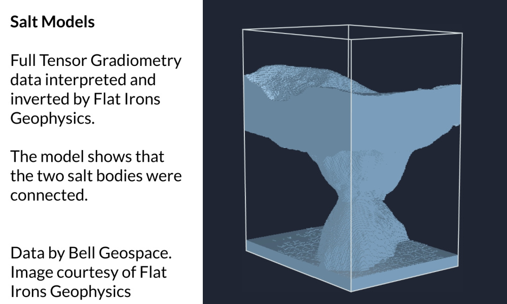
The second company then combined their seismic with the Bell Geospace FTG over the area. Via interpretations and inversions, FTG data was used by the expert interpreters at Earthfield Technology and Flat Irons Geophysics, in a model which showed that the two salt bodies were connected (Figure Three). With their new model, the operator could clearly see why they’d chosen the wrong area to drill into.
Bell Geospace, is currently working with the new leaseholders on 2D modeling exercises and is making recommendations for base modeling new acreage. Recommendations may include data merging or 3D salt modeling like that discussed in this article. There is a relatively strong density contrast between salt and background density structure making it an ideal environment for potential field data to play a vital role. Interpreters are regularly able to ascertain immensely valuable geological insights from this acquired data and operators have benefited from the comparatively minimal costs involved in data purchase.
Multiple scenarios can be run and legacy seismic can constrain the models and find the shoulder or flank of the salt instead of risking drilling into deep salt on the back of poor seismic reflectors. Understanding the extremities of the salt becomes entirely possible, relatively fast, and simple to achieve.
It is recommended that several models are used as constraints for the inversion process, created from the combined FTG and seismic data. This process can be done regionally over an entire basin or more detailed models can be built using a dedicated high-resolution airborne survey. In this case for the Gulf of Mexico, the marine multiclient FTG has already been acquired and so is ready to work with immediately.
Carbon Capture Storage
FTG data could additionally play an interesting role as underground storage becomes a reality. FTG identifies and delineates sub-surface density contrasts, be they generated by caverns, voids, shallow salt bodies etc. There are already engineering firms converting these sub-surface structures into storage sites. As FTG also maps fracture patterns, this is crucial for this application. It is clearly a most viable way forward to introduce FTG as an enabler in the Gulf of Mexico to help identify zones which could be followed up as potential development sites.
New Data Acquisition in Central America
A Bell Geospace aircraft will be traveling to Mexico in the New Year to acquire new airborne geophysical data in and around the Varacruz region. Operators located in U.S. and Central America are invited to make use of the Bell Geospace free feasibility study service, details of which are available online. Acquiring FTG data whilst a plane is in the region, significantly reduces the carbon footprint of exploration initiatives and comes with notable cost savings and operational efficiencies.
About the author: Julianne Sharples serves as international marketing manager at Bell Geospace. Sharples is based in the Edinburgh office and is responsible for global marketing initiatives, public relations and community liaison. Prior to joining Bell, she spent a decade with Ikon Science where she developed a passion for promoting leading technology in the geoscience industry. Her early career was spent with top London advertising agencies representing Procter & Gamble's FMCG products.
Recommended Reading

Cibolo Energy Closes Fund Aimed at Upstream, Midstream Growth
2024-09-10 - Cibolo Energy Management LLC closed its second fund, Cibolo Energy Partners II LP, meant to boost middle market upstream and midstream companies’ growth with development capital.

ONEOK Offers $7B in Notes to Fund EnLink, Medallion Midstream Deals
2024-09-11 - ONEOK intends to use the proceeds to fund its previously announced acquisition of Global Infrastructure Partners’ interest in midstream companies EnLink and Medallion.

Matador Offers $750 Million in Senior Notes Following Ameredev Deal
2024-09-20 - Matador Resources will offer $750 million in senior notes following the close of its $1.83 billion Ameredev II acquisition.

Affiliates of Oxy to Sell Western Midstream Common Units
2024-08-13 - Western Midstream Partners announced the pricing of the underwritten secondary public offering of its common units.

Summit Midstream Sets Pricing Terms of Senior Notes Due 2026
2024-07-25 - Summit Midstream Partners said the settlement date for the validly tendered notes is expected to occur July 26.
Comments
Add new comment
This conversation is moderated according to Hart Energy community rules. Please read the rules before joining the discussion. If you’re experiencing any technical problems, please contact our customer care team.