1 Ivanhoe Energy, Bakersfield, says it and its partners are preparing to log the Aera Energy LLC-operated #1-22 Northwest Lost Hills after having drilled the Kern County, Calif., wildcat to an approximate true vertical depth of 19,700 ft. At this depth, the well experienced a loss of drilling fluids and a significant flare of gas. Ivanhoe notes the well has been stabilized and is being conditioned in preparation for logging operations. The company says the decision was made to log the well at this point to evaluate approximately 3,000 ft. of Miocene Temblor that has been drilled. After logging results are evaluated, the partners will determine whether to begin completion operations or return to drilling. Top of the Temblor objective is at approximately 17,000 ft. Several drilling breaks and gas shows were encountered while drilling through the formation. The drillsite is in Section 22-25s-20e MD. Ivanhoe owns a 42% working interest in this well and has increased its net acreage ownership in the Lost Hills area to 9,600 acres, with an average 38% interest. Other joint venture partners in the #1-22 NWLH test include the operator, Bakersfield-based Aera Energy; Denver independent PYR Energy Corp.; and Ceniarth Inc. 2 According to the Nevada Oil Reporter, Nevada's Nye County has two new wildcats, one that's under way and the other one scheduled to be drilled soon. The drilling venture is the Trail Mountain Inc. #1 White Pine Dome Federal in Section 10-10n-59e, in the Horse Range. The Artesia, N.M., firm plans to drill to 10,000 ft. Sawyer Oil & Gas Co. LLC, Lewisville, Texas, is waiting on a rig to deepen a dry hole from an old total depth of 8,635 ft. to 10,000 ft. at the #4-15R Blue Eagle, Section 15-8n-57e, in Railroad Valley. 3 The Jurassic pool discovery for Utah's Flat Rock Field has been completed by Del-Rio Resources Inc. initially flowing 3.808 million cu. ft. of gas, eight bbl. of condensate and two bbl. of water per day. IHS Energy Group reports the discovery is the #29-6A Del-Rio/Orion in Section 29-14s-20e, Uintah County. The production, which is commingled from Cutler and Entrada between 11,452-11,540 ft., was gauged on a 28/64-in. choke. Half a mile northwest, Del-Rio confirmed the Jurassic production when it completed the #29-7A Del-Rio/Orion flowing 5.4 million cu. ft. of gas, 10 bbl. of condensate and four bbl. of water per day on a 32/64-in. choke. 4 Also in Uintah County, Natural Buttes Field is the site of a Cretaceous Mancos discovery that was finaled by El Paso Oil & Gas Co. flowing 2.079 million cu. ft. of gas and 200 bbl. of water per day on a 14/64-in. choke. The company's #3-181 Pawwinnee, in Section 3-9s-21e, is producing through perforations at 12,049-12,144 ft. The deeper-pool opener is in an area of Tertiary Wasatch production generally above 7,000 ft. 5 Montana's Apsaalooke Crows and Denver's Bill Barrett Corp. (BBC) have signed an energy development agreement that calls for a coalbed-methane production program on the Crow native American reservation in southeastern Montana. The agreement, recently ratified by the tribe's legislature, includes economic and education development components. It was in part managed by the Bureau of Indian Affairs' Denver and Billings offices. Terms of the agreement were not disclosed. 6 Lutre Field in Valley County, Mont., gained a 221-bbl.-per-day development oil well when Enid, Okla.-based Continental Resources Inc. recompleted the #1-29 Black Magic in Section 29-31n-44e. IHS Energy Group reports the well, which also yielded 150 bbl. of water per day, is producing through perforations at 5,966-86 ft. in the Mission Canyon member of Mississippian Madison. It was originally completed last March producing from Charles (Madison) at 5,681-5,718 ft. 7 An Ordovician Red River discovery completed by BTA Oil Producers near North Dakota's Beaver Creek Field initially pumped approximately 200 bbl. of oil per day. The Midland firm's #1 Red Tail "B" is in Section 14-143n-103w, Golden Valley County. It's producing through perforations at 12,570-90 ft. 8 Westport Oil & Gas Co., Denver, pumped 432 bbl. of oil and 104 bbl. of water per day from Glenburg (Madison) at the #7-25H Haugen-C, a horizontal well the company completed in Wiley Field, Bottineau County, N.D. The well's surface location is in Section 25-161n-82w. It's producing from an openhole horizontal interval from 4,016 ft. to 6,183 ft. 9 Ultra Petroleum, Houston, has a new-field discovery 1.25 miles south of Pinedale Field in Sublette County, Wyo. Ultra's 12,490-ft. #8-4 Riverside, Section 4-31n-109w, had a recorded initial production rate of 17.8 million cu. ft. of gas per day from 13 stages on a 24-hr. flow-back, surface constrained. Perforations are between 8,180-12,445 ft. in Cretaceous Lance and Mesaverde. From the first stage only, which includes the uppermost sand in Mesaverde, the well yielded gas at the rate of 13.5 million cu. ft. per day on a one-hr. flow-back without treatment and stabilized to a 3.5 million cu. ft. per day rate within three days. Ultra believes most of the gas on the test came from Mesaverde and that the well would have tested well over 20 million cu. ft. of gas per day if not constrained by surface facilities. 10 Also in Sublette County, EnCana Energy (formerly Alberta Energy) is testing an apparent gas discovery at the #14-20 Sagebrush in Section 20-27n-107w, according to the Rocky Mountain Oil Journal. Field reports credit the wildcat, eight miles southeast of Jonah Field, with yielding 3 million cu. ft. of gas per day from Mesaverde. The prospect was scheduled to go to 11,145 ft. in Mesaverde. EnCana plans to drill three more Mesaverde tests within three miles of its #14-20 Sagebrush. 11 Still in Sublette County, Chevron USA Inc. tested a flow of 16.94 million cu. ft. of gas per day from three Cretaceous Frontier zones on completion of the #28A La Barge Unit, a development well in La Barge Field. IHS Energy Group reports the well was directionally drilled from a surface location in Section 34-27n-113w to a total depth of 6,930 ft. Chevron tested the zones separately-3.097 million cu. ft. per day on a 44/64-in. choke from 6,603-6,794 ft. in Second Frontier subthrust; 6.681 million cu. ft. per day on a 30/64-in. choke from 6,126-52 ft. in First Frontier subthrust; and, 7.162 million cu. ft. per day on a 36/64-in. choke from 4,763-95 ft. in First Frontier subthrust. 12 Phoenix-based Copper Eagle Gas Storage LLC is set to drill two 9,000-ft. stratigraphic tests on the western outskirts of the Phoenix metropolitan area. The Maricopa County projects are the #1-12 Kakerlee LLP in Section 12-2n-2w and, 1.5 miles southeast, the #1 SunCor Development Co. in Section 19-2n-1w. Several similar tests have been scheduled or drilled in the general area. 13 Armstrong Resources LLC, Denver, has begun permitting discussions with the state of Alaska for an exploratory program scheduled for this winter in the Beaufort Sea south and west of Thetis Island. Three exploratory tests are included in the program-the #1 test in Section 7-13n-8e, Umiat Meridian; the #2 in Section 31-14n-8e, UM; and the #3 in Section 16-13n-8e. IHS Energy Group reports access to the three drillsites will be by about 10 miles of sea-ice roads. 14 The oil and gas lease sale of National Petroleum Reserve-Alaska (NPR-A) acreage held by the U.S. Bureau of Land Management in Anchorage in June attracted high bids totaling $63,811,496. The bids were for 60 parcels made up of 579,269 acres. The average per-acre bid was $110.15. The sale offered 299 tracts encompassing about 3 million acres in the northeast corner of the NPR-A. Eight companies participated in the sale, with TotalFinaElf E&P USA being the top bidder, paying $53,532,000 in high bids for 20 tracts covering 228,754 acres. The company's average per-acre bid was $234. The company made the top two overall and per-acre bids at the sale, paying $10,188,480 ($887.81 per acre) for Tract L-199, an 11,476-acre lease in Township 9n-7w, and $10,187,590 ($889.67 per acre) for Tract L-210, an 11,451-acre lease in Township 10n-5w.
Recommended Reading

Aggreko ETS Acquires Solar Project in Texas
2024-02-01 - Aggreko Energy Transition Solutions will oversee construction, own and operate the clean energy project in support of a Texas energy producer’s drive to decarbonize operations.

RIC Energy Sells Seven Solar Plants in New York to Radical Power
2024-03-22 - In recent months, RIC Energy sold 13 photovoltaic plants in the state of New York with a total capacity of 70 MW to various companies.
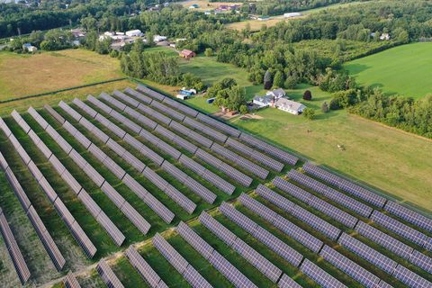
RIC Energy Sells 20 MW of Solar Plants to Luminace
2024-03-04 - RIC Energy says the facilities are expected to provide 100% clean energy to more than 5,000 homes participating in the utilities’ community solar programs.

EnCap Launches Bildmore to Invest in Hard-to-finance Clean Energy
2024-03-11 - In an effort to support hard-to-finance clean energy projects, EnCap Energy Transition Fund is launching Bildmore, a platform expected to invest in up to 15 third-party battery storage, solar and other energy transition projects per year.

Devon Energy Leads $244MM Funding Round for Fervo Energy
2024-02-29 - The funds will finance Fervo Energy’s next phase of growth as it puts to use oil and gas technology and techniques to scale geothermal energy.