1 The Aera Energy LLC #1-22 NWLH well in Kern County, Calif., has been drilled to a total depth of 20,457 ft., with casing installed in preparation for production testing. The well is in Section 22-25s-20e, about 1.5 miles east of Northwest Lost Hills Field. 2 Bakersfield, Calif.-based independent Tri-Valley Oil & Gas began drilling the Aurora #1-19, a new wildcat about six miles east of McFarland, Calif., in Section 19-26s-26e. The company hopes to discover an estimated 18 million bbl. of oil. The Aurora prospect is one of 26 separate prospects part of the TVOC Opus 1 Drilling Program LP, which the company has under way in Kern County. 3 El Paso Production Oil & Gas Co. has set 3.5-in. production liner to a total depth of 14,250 ft. at a Uinta Basin wildcat, according to IHS Energy. The #26-32 Ute Tribal is about 13 miles southeast of Duchesne in western Uintah County, Utah. The 14,400-ft. well, in Section 26-4s-2e, flowed an undisclosed amount of gas through perforations in three zones: Mesaverde at 10,693-10,703 ft.; Lower Mesaverde at 12,535-12,986 ft.; and Mancos at 13,186-13,904 ft. El Paso shut in the discovery upon completion. There is no pipeline in the vicinity. 4 Retamco Operating Inc., Roberts, Mont., scheduled a 5,480-ft. wildcat in a nonproducing township about three miles east of Bonanza, Utah. The #15 Hoss is in Section 20-9s-25e, eastern Uintah County. The well will be drilled 4.5 miles south of a Green River gas well completed in 1971 in Lone Mountain Field. That 2,389-ft. well flowed 318,000 cu. ft. of gas per day through perforations between 2,296-2,330 ft. It was shut in upon completion. 5 Horizontal Bakken tests are planned in northeastern Montana's Richland County by BBX Operating LLC and Headington Oil LP. BBX, based in Austin, Texas, staked a 15,800-ft. horizontal Bakken test at the #15-1H Belleza in Section 15-24n-54e. Drilling plans include kicking off the vertical hole at a depth of 9,200 ft., with a true vertical depth estimated at 9,800 ft. About three miles away, Dallas-based Headington will drill a dual-lateral horizontal Bakken test at the #21X-30 Roberts in Section 30-24n-55e. 6 IHS Energy reports that state permits have been received for three Red River exploratory tests in Richland County, Mont. Dallas-based Petro-Hunt LLC will drill an 11,500-ft. test at the #11C-2-1 BR, Section 1-22n-53e, about 35 miles west of Sidney. The company also will drill a 12,000-ft. test about eight miles away at the #13D-1-1 BR in Section 13-23n-54e. In northeastern Richland County, Oklahoma City-based independent Chesapeake Energy Corp. will drill a 12,900-ft test at the #1-32 Irma in Section 32-26n-57e, about 15 miles southwest of Bainville. 7 Gas was recovered at a rate of 594,000 cu. ft. per day at a production test on a wildcat drilled in Sublette County, Wyo. Burlington Resources Oil & Gas Co. LP tested the #33-27 Muddy Creek Unit, Section 27-30n-111w, in Mesaverde between 8,264 and 8,887 ft. Flow was gauged through a 20/64-in. choke with a flowing tubing pressure of 359 psi. Burlington then set a bridge plug at 7,940 ft., closing off the Mesaverde zone and perforating the shallower Lance between 7,384 and 7,830 ft. An initial potential rate for the Lance zone was not disclosed. Burlington plans to commingle production from the Lance and Mesaverde zones, eventually. 8 EnCana Oil & Gas Inc. has applied for two drilling permits for wildcats in Sublette County, Wyo., to evaluate the gas potential of the Lance and Mesaverde zones. The planned 9,136-ft. #11-36 Sugar Loaf, Section 36-27n-109w, is about two miles away from HS Resources Inc.'s completed #11-24 Scarlet Unit, Section 24-27n-109w. That 9,610-ft. discovery gave up about 72.6 million cu. ft. of gas, 1,145 bbl. of condensate and 213 bbl. of water before being shut-in in early 2002. The second permit is for EnCana's planned 9,440-ft. #5-22 Palomino, Section 22-29n-110w. This wildcat is about eight miles away from a McMurry Oil Co. location, staked as a 10,100-ft. Lance test at the #6-9 Corona, Section 9-28n-109w. 9 Denver-based GMT Energy Inc. completed an exploratory test in the Red Desert Basin of southern Wyoming, according to IHS Energy. The #34-1R Federal, Section 34-20n-101w, Sweetwater County, flowed 408,000 cu. ft. of gas per day through an 8/64-in. choke with a flowing tubing pressure of 1,600 psi. The well is a workover of a 7,241-ft. dry hole drilled in 1978. It is nearly two miles from an 8,100-ft. Frontier producer that was completed in 1976 flowing 373,000 cu. ft. of gas per day. 10 Bellevue Resources Inc., Calgary, is currently drilling a 9,300-ft. Minnelusa test in Wyoming's Powder River Basin. Cyclone Drilling's Rig #7 is directionally drilling the #1 Hart Draw-Federal from a surface location in Section 20-57n-72w, northeastward to a projected bottom-hole location of the same section. The venture is a little more than a mile southeast of Ormsby Road Field discovery, a 13,274-ft. well completed in 1991 flowing 156 bbl. of oil and 153,000 cu. ft. of gas per day. 11 A pair of Muddy sand tests have been staked in Wyoming's Borie Field by Denver-based Ensign Operating Co. The southwestern Laramie County projects are the #23-11 King, Section 11-13n-68w, projected to 9,250 ft.; and the #14-24 Borie Muddy Unit, Section 24-13n-68w, projected to 9,100 ft. The #23-11 King is in an unspaced area on the northwestern side of Borie Field. It offsets to the west a Borie Field well completed in 1990. The #14-24 Borie Muddy Unit offsets Muddy producers on the southeastern side of Borie Field. 12 EnCana Energy Resources is planning more gas exploration tests in a nonproducing area of northwestern South Dakota, according to IHS Energy. The western Harding County wildcats are: the #4-4-18n-4e Gilbert, Section 4-18n-4e, projected to 1,800 ft. in Shannon and Eagle; the #5-15-8n-4e Gilbert, Section 15-18n-4e, projected to 1,950 ft. in Shannon and Eagle; and the #10-9-18n-4e Gilbert, Section 9-18n-4e, projected to 1,900 ft. in Shannon and Eagle. The tests are located nine to 12 miles south of Buffalo Field, a Red River oil reservoir, and 16 to 17 miles east-northeast of West Short Pine Hills Field. 13 Rocky Mountain Gas Supply LLC, New Mexico, scheduled three exploratory tests near the company's Dakota (Cretaceous) gas discovery in Huerfano County, Colo. The ventures, set up to evaluate the Dakota and Entrada, are: the #4 Willis, Section 4-29s-69w, with a proposed bottom-hole location of 33-28s-69w; the #1 Caddell, Section 4-29s-69w; and the #1 Andreatta, Section 10-29s-69w. The sites are on the northern flank of the Raton Basin, within two miles of the operator's #1 White discovery in Section 9-29s-69w. 14 An agreement signed with Denver's Armstrong Resources LLC gave Dallas-independent Pioneer Natural Resources Co. a 70% working interest in, and operatorship of, 10 state oil and gas leases on Alaska's North Slope. The leases cover about 14,000 acres between the Kuparuk River Unit and Thetis Island. Pioneer plans to drill up to three wells this winter in an area it believes contains oil in the same sands as those producing at the Kuparuk River Unit about 10 miles away. No wells have been drilled on the acreage covered by Pioneer's leases to date, but those drilled just outside the perimeter have encountered the primary target, the Kuparuk "C" sands, and were oil-bearing. 15 IHS Energy reports the Alaska Division of Oil and Gas approved Marathon Oil Co.'s application for the creation of the Kasilof Unit. The 13,289-acre unit includes three state of Alaska oil and gas leases in state waters about five miles south of Cape Kasilof. The anticlinal trend that is the basis of the proposed unit begins near the mouth of the Kasilof River and extends south for five miles. Marathon indicated that the potential gas-producing reservoir is in the Tyonek formation, and an initial well will be drilled to that formation.
Recommended Reading

Solar Panel Tariff, AD/CVD Speculation No Concern for NextEra
2024-04-24 - NextEra Energy CEO John Ketchum addressed speculation regarding solar panel tariffs and antidumping and countervailing duties on its latest earnings call.

NextEra Energy Dials Up Solar as Power Demand Grows
2024-04-23 - NextEra’s renewable energy arm added about 2,765 megawatts to its backlog in first-quarter 2024, marking its second-best quarter for renewables — and the best for solar and storage origination.
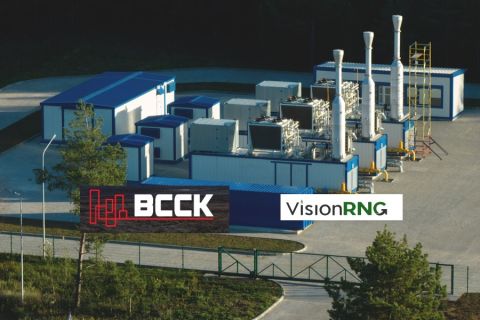
BCCK, Vision RNG Enter Clean Energy Partnership
2024-04-23 - BCCK will deliver two of its NiTech Single Tower Nitrogen Rejection Units (NRU) and amine systems to Vision RNG’s landfill gas processing sites in Seneca and Perry counties, Ohio.

Clean Energy Begins Operations at South Dakota RNG Facility
2024-04-23 - Clean Energy Fuels’ $26 million South Dakota RNG facility will supply fuel to commercial users such as UPS and Amazon.

Romito: Net Zero’s Costly Consequences, and Industry’s ‘Silver Bullet’
2024-04-22 - Decarbonization is generally considered a reasonable goal when presented within the context of a trend, as opposed to a regulatory absolute.