The Pelotas Basin is an underexplored, untapped hydrocarbon province comprising a 500,000-sq-km (193,050-sq-mile) passive margin located on the southeast coast of Brazil and Uruguay to the south.
Of the nine wells drilled in Brazil, lack of charge suggests that the main risk factors are due to uncertainty in the presence of source rock and migration pathway. However, seismic evidence suggests the presence of an actively generating interval in the Upper Cretaceous or Early Paleocene similar in character to those found in the Niger Delta in West Africa and the basins offshore Mozambique and Tanzania. Additional source rocks may exist regionally in the Turonian and Albian and in local rift basins in the Aptian. The Deep Sea Drilling Project site 359 encountered 4 m (13 ft) of Turonian organic-rich shales with 2% to 12% total organic carbon. Earlier seismic data as well as recent high-quality 2-D seismic surveys have imaged multiple potential reservoir intervals, traps, source rocks and direct hydrocarbon indicators in the basin. The Lower Cretaceous, Upper Cretaceous and Tertiary periods appear to have evidence of second-order regressive sequences that delivered siliclastic sediment to the deepwater.
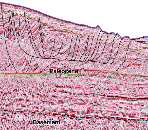
FIGURE 1. A prestack time-migrated seismic section shows the BSR (yellow horizon). (Source: Spectrum Geo)
Evidence for hydrocarbons
The seismic data show that since the inception of rifting between South America and Africa (at 125 Ma), the position of depocenters of paleo tributaries of the Rio de la Plata moved along the margin several times. A recent depocenter forms a bathymetry feature named the Rio Grande Cone that comprises a 4-km (2.5-mile) thick Tertiary siliclastic sequence. This sequence displays a world-class direct hydrocarbon indicator in the form of a 40,000-sq-km (15,444-sq-mile) sheet of bottom simulating reflectors (BSRs) confined inside the 3,000-m (9,842-ft) Tertiary isopach (Figure 1). The Tertiary delta has prograded over and matured a Paleocene source rock. Gas and condensate from this source rock subsequently migrated up through the sedimentary prism via abundant gas chimneys and plumes to be trapped by the gas-water crystal phase change creating the BSR (Figure 2).
There is also evidence of oil seeps detected by synthetic aperture radar and standard satellite imagery in the southern Pelotas Basin. This may suggest a linear feature approximately coincident with the 500-m and 800-m (1,640-ft and 2,625-ft) isobaths. It is hypothesized that oil generated at depth below the Tertiary prism is migrating up to the impermeable solid base of the hydrate until it reaches the updip extent of the BSR.
There is gas or liquid trapped by stratigraphy or structure below the BSR creating a shallow gas or oil play within the Tertiary prism itself trapped in porous intervals below the solid hydrate layer, possibly a secondary play. Despite the abundant gas in these sequences, it is the potential for large oil plays that is refocusing the attention of E&P companies in the Pelotas Basin.
The BSR represents the base of a solid layer of gas hydrates. The pressure and temperature conditions necessary for the formation of hydrate crystals require an environment with water depths greater than 300 m (984 ft). The associated gas hydrates exist from about 100 m (328 ft) to as deep as 500 m beneath the sea floor. The velocities of hydrates are considerably higher than the equivalent-aged sediment just below the seabed.
The BSR may provide additional information about the heat flow and distribution of hydrocarbon generation in the region. Regional mapping of the distribution of the BSR shows a strong correlation with an isopach thick that defines the Rio Grande Cone depocenter. The isopach thick also defines a region that is within the gas window for potential source rocks in the Aptian and Albian. This suggests the BSR is due to thermogenic gas and liquids. If the gas in the BSR was derived from biogenic gas, it would be likely that the BSR would have a more regional extent and perhaps a more variable distribution.
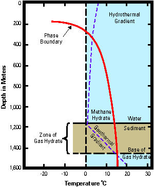
FIGURE 2. A depth profile illustrates the interaction of the hydrate stability boundary with the cold ocean water temperatures and the heat from the earth for a section in 1,200 m (3,937 ft) of water. (Source: Spectrum Geo)
Petroleum system
The conjugate margin rift basins of West Africa and Brazil initially formed by east-west extension initiated during the early Cretaceous as the South American plate began to separate and rotate clockwise from Africa.
Both the Pelotas and Namibian basins are underlain by thickened high-density volcanic crust with an abundance of seaward-dipping reflectors. Basin subsidence is controlled both by long-term post-rift thermal cooling and differential sediment loading and accommodation. The seismic data in the area illustrate that the Pelotas Basin received substantially more sediment than the Namibe Basin, and consequently the basement is deeper.
In the Pelotas Basin, the prograding Tertiary wedge over the Paleocene source rock triggered a glide-plane detachment within the source rock similar to the Niger Delta. Structural traps are developed within this gravity-driven structural complex along listric normal faults updip and toe-thrust structures downdip. The Orange River Basin in Namibia exhibits a similar though older feature with a deeper detachment on the Cenomanian-Turonian source rock.
Although few wells have penetrated the deepwater section of either margin, the interpretation of the seismic data suggests deltaic processes generated numerous potential plays. The supply of sediment from the shelf and delta to the post-rift thermally subsiding margin was subject to both global sea level change and locally controlled delta lobe switching. The seismic data in the area indicate that a potential reservoir was deposited by mechanisms common to many passive margin mixed-source deltaic systems. Lowstand sands are interpreted within prograding siliciclastic wedges in addition to lowstand slope fan sands.
In the early Cretaceous, Aptian-Albian carbonates may have formed locally, creating a very exciting play interbedded with source rock. Additionally, during the Lower and Upper Cretaceous and Tertiary, prograding units appear to have suffered shelf collapse and slope failure in parts of the basin, depositing turbidites, channel fill and thick stacked slump sequences on the basin slope and floor.
Exploration opportunities
There is considerable evidence of a large working petroleum system with a Paleocene source rock presently within the oil window, and correlation with the conjugate margin provides evidence of source rock in the Albian section, which opens up a second deepwater oil play. A more detailed examination of the seismic data indicates that the deepwater Pelotas Basin may contain more prospective targets than the shelf, with reservoir and charge presenting the key technical risks. There are many good reasons to believe that the deepwater Pelotas Basin warrants further exploration.
Recommended Reading
Oil Broadly Steady After Surprise US Crude Stock Drop
2024-03-21 - Stockpiles unexpectedly declined by 2 MMbbl to 445 MMbbl in the week ended March 15, as exports rose and refiners continued to increase activity.

US Refiners to Face Tighter Heavy Spreads this Summer TPH
2024-04-22 - Tudor, Pickering, Holt and Co. (TPH) expects fairly tight heavy crude discounts in the U.S. this summer and beyond owing to lower imports of Canadian, Mexican and Venezuelan crudes.
Imperial Expects TMX to Tighten Differentials, Raise Heavy Crude Prices
2024-02-06 - Imperial Oil expects the completion of the Trans Mountain Pipeline expansion to tighten WCS and WTI light and heavy oil differentials and boost its access to more lucrative markets in 2024.

What's Affecting Oil Prices This Week? (March 11, 2024)
2024-03-11 - Stratas Advisors expects oil prices to move higher in the middle of the year, but for the upcoming week, there is no impetus for prices to raise.
Oil Dips as Demand Outlook Remains Uncertain
2024-02-20 - Oil prices fell on Feb. 20 with an uncertain outlook for global demand knocking value off crude futures contracts.