(Source: PGS)
[Editor's note: A version of this story appears in the May 2020 edition of E&P. Subscribe to the magazine here.]
A more efficient approach to upgrading subsurface imaging of complex geology that combines advanced towed-streamer acquisition techniques with modern imaging processes was needed. PGS developed GeoStreamer X to address illumination challenges with a seismic survey design adapted to the local geological challenges, along with towed-streamer efficiency that guarantees timely delivery of results. Multisensor recordings enable advanced processing to achieve significant improvement of existing data. These recordings are provided by multiple sources for improved spatial sampling and efficiency; wide-tow sources for optimal near-offset coverage and amplitude with variation offset (AVO); longer offsets for reliable velocity model building; and cost-effective multi-azimuth (MAZ) illumination. This results in rapid turnaround from acquisition to the final image.
The method explained
This concept improves spatial sampling, adds complementary azimuths and additional long offset data from new multisensor broadband acquisition. This new information enhances existing data to provide better input for advanced model building and imaging workflows and quantitative interpretation.
A survey design exercise to identify offsets required for advanced velocity model building and azimuths to improve illumination of target horizons. Imaging, survey planning and operational experts work closely to tailor the project design to the targets. Efficiency and coverage are key parameters to produce an optimal MAZ survey. The resulting survey design delivers more advanced high-resolution imaging of complex targets in a time-efficient manner.
Pilot project
GeoStreamer X was first deployed in 2019 over the Viking Graben offshore Norway to help resolve the illumination and resolution challenges that affect many of the exploration and development areas within the basin. The GeoStreamer X pilot was designed to address the imaging challenges.
The Ramform Vanguard towed 12 high-density multisensor streamers 85 m apart and a wide-tow triple source configuration with 225-m separation between the outer source arrays. Two of the streamers had 10-km-long tails (Figure 1). This was the widest-ever source separation towed by a single streamer vessel on a commercial project.
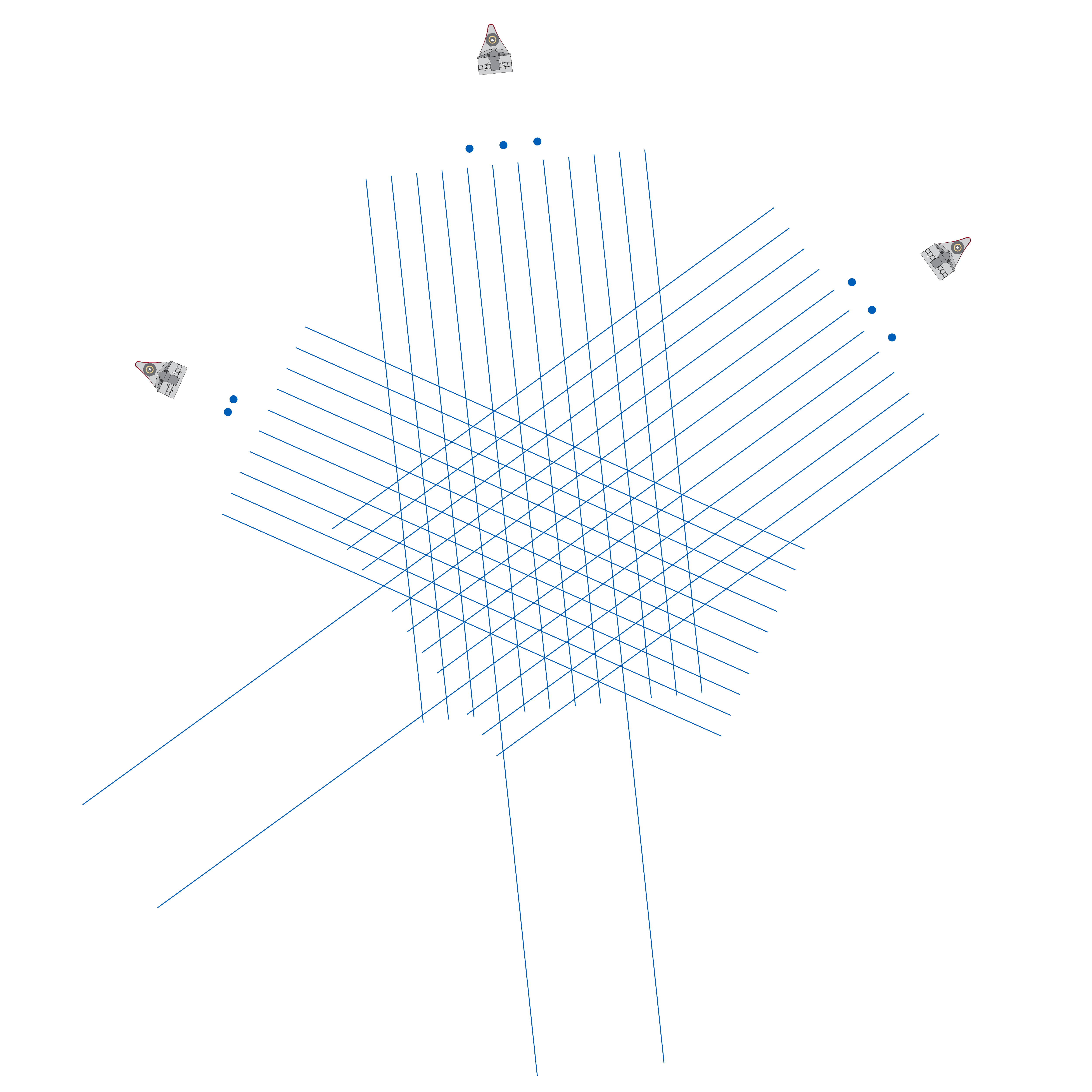
During 2019, total source separations of up to 250 m from a single acquisition vessel have been successfully tested by PGS and will be deployed when applicable in 2020. Distributing multiple wide-tow sources along the front of a streamer spread provides geophysical benefits, mainly by improving the near-offset coverage.
Towed streamer surveys with a standard source set up in front of the center streamers may not give the near-offset/near-angle coverage required for AVO analysis. Wide-tow sources are especially relevant for shallow targets in shallow-water environments. Towing multiple sources wider also can provide efficiency gains. As the distance from the outer streamers to the nearest sources is reduced, wide-tow sources enable wider streamer spreads and increased lateral data coverage, improving turnaround, without sacrificing near offsets.
Solving challenges in Brazil
There are many factors that make survey design in Brazil challenging. Large structures of salt combined with deep sediment basins and volcanic rocks set the background for very deep reservoirs and represent very challenging geology to image. Meanwhile, environmental regulations constrain the operational parameters for seismic acquisition. This combination of geological and operational challenges is best addressed by a well-managed holistic approach for the entire process covering planning and geophysical modeling, operations in the field, and advanced processing and imaging of the data.
PGS has a large footprint of multiclient data and extensive operational experience in Brazil. This provides many opportunities to design and deploy GeoStreamer X acquisition configurations that best meet the complex imaging challenges in Brazil. Building a large-scale model that incorporates realistic details from a number of different major discoveries makes it possible to test different acquisition configurations. They can be evaluated to see which configuration best addresses the geological, geophysical and operational challenges.
With advances in full-waveform inversion (FWI) earth-model building workflows, making sure the acquisition configuration provides the best data possible for FWI has become a critical step in survey design. Confidence in the velocity model building process can be increased by adding refracted energy. The PGS FWI method uses diving waves, refractions and reflections to deliver deep velocity model updates in a stable manner without relying on very long offsets.
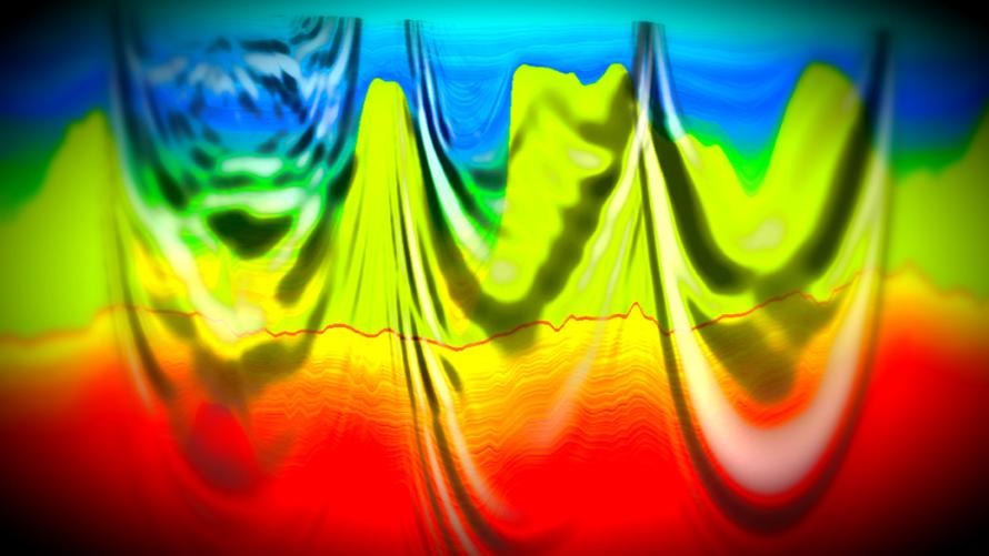
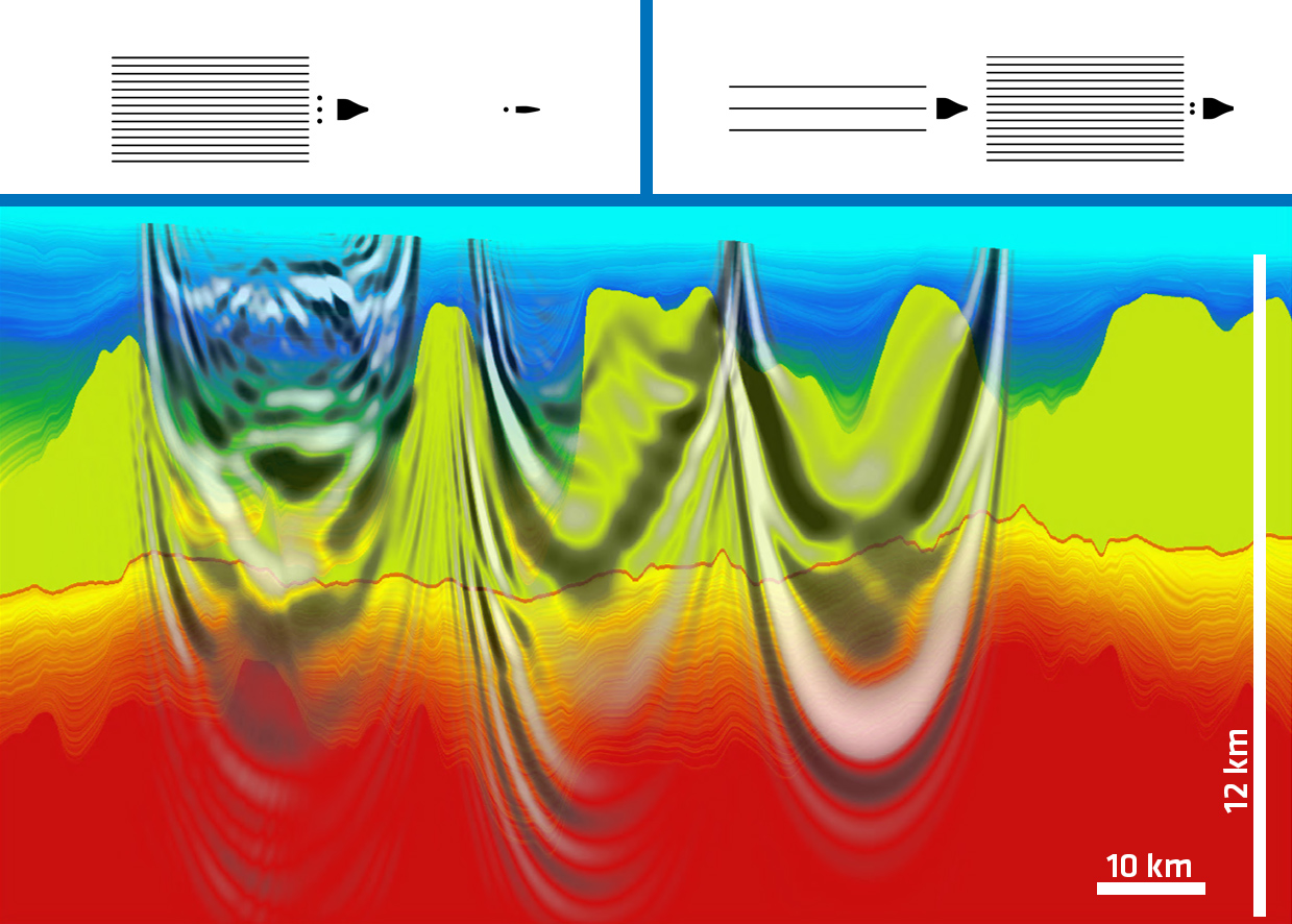
The example shown in Figure 2 is based on a cross-section, representing the geology of the Carcará discovery. It was used to determine the offsets required to achieve velocity updates using refracted energy in FWI. With both reflected energy and diving waves, it becomes possible to increase the bandwidth for FWI to higher frequencies, achieving unprecedented resolution at the level of presalt reservoirs.
Using a model derived from real data for FWI feasibility studies demonstrates that diving wave velocity updates will reach the Santos Basin presalt with offsets less than 20 km, well within the operational range of modern streamer acquisition configurations.
Expanding coverage
A GeoStreamer X design for Brazil needs to deliver sufficient offsets for presalt FWI while meeting regulatory requirements. Advanced modeling of synthetic data in the complex geology in Brazil shows that it is possible to achieve the required offsets using towed-streamer seismic. Several streamer geometries have been identified that record long offsets with minimal environmental footprint. The most efficient solution is a standard long-offset configuration from a single vessel towing a tailored source. Alternatively, highly effective configurations can provide even longer offsets, such as simultaneously acquired, sparse-source long offsets where additional sources and additional receivers may be towed by a separate vessel. In all cases, combining these streamer geometries in a MAZ survey to improve illumination is expected to provide excellent images of presalt targets.
By using existing data and experience, surveys can be designed to enhance existing datasets and get the best images and information in a wide variety of geological settings while complying with local regulations.
Recommended Reading

PHX Minerals’ Borrowing Base Reaffirmed
2024-04-19 - PHX Minerals said the company’s credit facility was extended through Sept. 1, 2028.
SLB’s ChampionX Acquisition Key to Production Recovery Market
2024-04-19 - During a quarterly earnings call, SLB CEO Olivier Le Peuch highlighted the production recovery market as a key part of the company’s growth strategy.

BP Restructures, Reduces Executive Team to 10
2024-04-18 - BP said the organizational changes will reduce duplication and reporting line complexity.

Matador Resources Announces Quarterly Cash Dividend
2024-04-18 - Matador Resources’ dividend is payable on June 7 to shareholders of record by May 17.
EQT Declares Quarterly Dividend
2024-04-18 - EQT Corp.’s dividend is payable June 1 to shareholders of record by May 8.