In a study examining the hydrocarbon exploration potential of the BMS-50/52 seismic survey area within the Santos Basin offshore Brazil, results are based on preliminary geological interpretation of 3-D multiclient prestack depth-migrated (PSDM) seismic surveys acquired and processed by PGS. Most of the survey area is expected to be offered in future presalt bid rounds by ANP, the Brazilian E&P regulatory agency.
The BMS-50/52 surveys are within the presalt play polygon of the Santos Basin (Figure 1). Several recent multibillion-barrel light oil discoveries have been made in this play since 2006 after the Tupi (Lula) discovery opened a new E&P frontier in the deep waters of the Santos and Campos basins. These recent discoveries have more than doubled Brazilian hydrocarbon reserves and, as the great majority of the BMS-50/52 survey area, much of the Brazilian presalt play remains under- or unexplored and available for licensing.
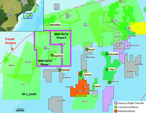
FIGURE 1: The BMS-50/52 survey covers some of the prospective presalt acreage offshore Brazil. (Source: PGS)
The seismic dataset used in this interpretation work is made up of two surveys: Phase I, a conventional single-sensor PSDM seismic volume, and Phase II, a dual-sensor GeoStreamer PSDM volume. The 2012 dual-sensor broadband survey was acquired adjacent to the west of the conventional solid streamer survey shot in 2008. The surveys have a narrow overlap zone of 2 km (1.2 miles), which allows a comparison of the two datasets as well as the assertions of improved imaging and data quality arising from dual-sensor broadband data to be validated.
Survey implications
Implications of significant improvement on seismic imaging and geological interpretation of the BMS-50/52 surveys will be critical for:
- The unitization of the Carcará and Sagitário discoveries;
- The unitization of future discoveries in BM-S-50 or BM-S-8 that straddle block boundaries into open acreage;
- The identification and delimitation of the remaining hydrocarbon potential of the presalt play in the area;
- The identification and delimitation of the remaining exploration opportunities in the area, including potential older rift/prerift and post-salt plays; and
- A local to semiregional revision of the Santos Presalt polygon in the Santos Basin.
Presalt, adjacent hydrocarbon discoveries
The Santos/Campos presalt hydrocarbon play consists mainly of rift/sag-sourced oils accumulated in carbonate reservoirs of the sag phase and trapped in structural features or paleo-topographic/depositional highs beneath the base of the salt. The overlying thick evaporitic succession provides the main sealing unit for the accumulations.
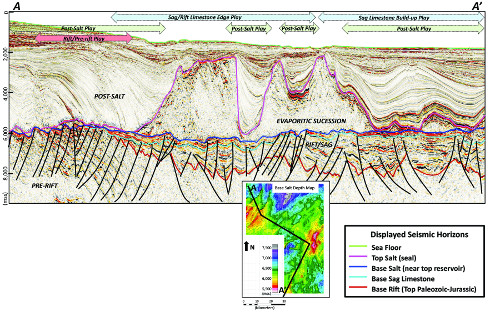
FIGURE 2: This regional seismic cross section shows the regional seismic hydrocarbon exploration plays. (Source: PGS)
The survey area includes and is surrounded by important presalt hydrocarbon discoveries. The Sagitário discovery (1-BRSA-1063-SPS well) in the exploration block BM-S-50, announced in February 2013 by Petrobras and its partners, is located in the central-western portion of the Phase I survey. In adjacent areas, there are two major presalt hydrocarbon discoveries worthy of mention: Parati (1-BRSA-329D-RJS well), the first hydrocarbon success in the Santos presalt play announced in 2006 by Petrobras and its partners in the BM-S-10 block, and the Carcará discovery (1-BRSA-532A-SPS and 4-BRSA-971-SPS wells) also announced by Petrobras and its partners in the BM-S-8 exploration block. Carcará extends into open acreage within the southern portion of the BMS-50/52 surveys. To the north of the surveys there also is an important post-salt gas/condensate field, Mexilhão, covered by the PGS MultiClient BS-400, BMS-4 MC3D seismic surveys.
Hydrocarbon exploration trends
Several horizons can be easily mapped in the seismic volumes. However, Phase II data show much improved subsalt imaging. These new seismic data allow for more confident geological interpretation of the data. The following horizons were mapped: seafloor, top salt, base salt (top reservoir), base carbonate reservoir, base rift (top of the Paleozoic) and top basement (Figure 2).
These horizons, combined with improved imaging of faults and delimitation of the main tectonic compartments, allow a better understanding of the structural and stratigraphic evolution of the BMS-50/52 area. Several paleo-depocenters of the rift/sag succession might indicate that the main Santos source rock is likely to be present throughout most of the study area, most likely within the hydrocarbon generation window and potentially with the same high generation potential as the main presalt heartland in Santos. Obviously, this would have to be confirmed by some well measurement. However, the presence of commercial hydrocarbon in Sagitário and the observation of a very large hydrocarbon column in Carcará may provide a strong support to the presence of this robust source rock in the area. Consequently, billions of barrels of oil and gas/condensate could have been generated in the depocenters of the BMS-50/52 area. In the south-central portion of the survey, the generated hydrocarbon is potentially trapped in four-way closures at the base salt and sealed by the thick overlying evaporitic succession, similar to Carcará and Sagitário. Post-salt and rift/prerift plays may take more importance in shallower water depths to the north.
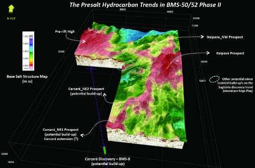
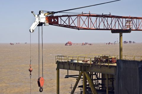
FIGURE 3: Phase II of the survey employed dual-sensor streamers. (Source: PGS)
Exploration plays
The hydrocarbon exploration plays (Figure 2) within the survey area are:
- Post-salt in the northern segment, most likely a moderate-risk gas/condensate trend with hydrocarbons trapped mainly in Albian limestones in structural traps or Upper Cretaceous to Lower Tertiary turbidites in combination or stratigraphic traps;
- Rift/prerift in the central-western area, most likely a high-risk gas/condensate trend with hydrocarbon accumulation within small fault traps in siliciclastic reservoirs of the Paleozoic (prerift) layers to the Lower Cretaceous rift succession. During the Late Barremian to Aptian, this area was a sub-aerially exposed paleo-high where the sag/rift carbonates are absent or inexpressive;
- Sag/rift limestone edge (or Sagitario trend), with light oil accumulated within structural traps beneath the base salt in microbial platform limestones and occasional isolated microbialite buildups. This hydrocarbon play has a southwest-northeast orientation and is most expressive in the BM-S-50 area. A moderate risk should be assigned to this trend since the seismic imaging under the thicker salt is still quite challenging in the current Phase I PSDM dataset when compared to the recent dual-sensor streamer seismic survey; or
- The Carcará North/Itaipava sag limestone, a potential light oil southwest-northeast-oriented trend that extends from the Carcará discovery in BM-S-8 to the Itapaiva Paleo-High in the eastern-central segment, totaling a few hundred square kilometers of individual closures beneath the base salt and relief reaching 300 m to 400 m (984 ft to 1,312 ft, Figures 3 and 4). In this trend, oil is accumulated on paleo-topographic highs (potentially representing very large microbial buildups). This trend is the largest-reward and lowest-risk play and is most expressive in the Phase II survey. The depositional features are analogous to other large presalt features in Libra and Sapinhoá (Guará) and are clearly identifiable in the dual-sensor streamer dataset, even under very thick evaporitic layers.
By analogy with other areas in Santos, the BMS-50/52 area has a large hydrocarbon exploration potential, with possibilities for significant light oil discoveries. Geological and geophysical interpretation of the survey area reveals a great diversity of potential hydrocarbon accumulation styles, including presalt, post-salt and Paleozoic rift plays. Presalt exploration trends in the southern part of the survey area are the lowest-risk, most attractive opportunities, and the newer seismic data afford improved subsalt imaging and identification of potential reservoir sweet spots. Most of the Carcará/Itaipava trend is on open acreage expected to be offered in future ANP bid rounds. Other frontier plays are identified within more proximal shallow-water areas. High-quality seismic data together with the better understanding of the petroleum systems in the area will provide important input for the unitization of Carcará, Sagitário and any other future discoveries that may straddle block boundaries.
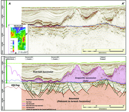
FIGURE 4. This fullstack PSDM cross section shows the south-southwest/north-northeast trend through the Carcará-Itaipava exploration area. Analogues to the Carcará well are seen in this image, which are four-way closures beneath the base salt and represent great exploration opportunities. (Source: PGS)
Recommended Reading
TotalEnergies Starts Production at Akpo West Offshore Nigeria
2024-02-07 - Subsea tieback expected to add 14,000 bbl/d of condensate by mid-year, and up to 4 MMcm/d of gas by 2028.

E&P Highlights: Feb. 5, 2024
2024-02-05 - Here’s a roundup of the latest E&P headlines, including an update on Enauta’s Atlanta Phase 1 project.
CNOOC’s Suizhong 36-1/Luda 5-2 Starts Production Offshore China
2024-02-05 - CNOOC plans 118 development wells in the shallow water project in the Bohai Sea — the largest secondary development and adjustment project offshore China.
US Drillers Cut Oil, Gas Rigs for First Time in Three Weeks
2024-02-02 - Baker Hughes said U.S. oil rigs held steady at 499 this week, while gas rigs fell by two to 117.

Equinor Receives Significant Discovery License from C-NLOPB
2024-02-02 - C-NLOPB estimates recoverable reserves from Equinor’s Cambriol discovery at 340 MMbbl.