As exploration in a basin progresses, multiple adjacent 3-D surveys often are acquired. Each survey is typically acquired with the latest technology and parameters designed to optimize imaging of the target(s) in the area of the survey. Differences in survey parameters from one survey to the next can cause problems when developing a regional interpretation across multiple vintages of legacy data.
The traditional approach to matching multiple surveys has been to design customized filters to resolve frequency, amplitude and phase discontinuities at the boundaries between surveys. Unfortunately, this technique often has the effect of dumbing down all surveys to some lowest common denominator of resolution and amplitude fidelity.
The recent development of broadband deghosting techniques pioneered by ION offers a much more elegant and improved alternative, in which each survey is restored to full bandwidth, enabling a clean phase and amplitude match between multiple surveys while preserving or enhancing the resolution of all the constituent surveys.
Challenge of survey matching
Three-dimensional surveys may be acquired several years apart (almost 20 years as is the case here), and it is natural to use the best available technology at the time of shooting—possibly using different acquisition systems. Differences between the systems could include variations in source signature and instrument response. These differences are fairly simple to resolve either deterministically (using known instrument responses and derived or measured source signatures) or statistically (as used in this case history, using a least squares adaptive matching approach).
The real challenge relates to the tow depths of the source and streamer. In a seismic recording system, energy travels down from the source, reflects off the subsurface target and then ascends to the receivers. In the marine environment, this picture is complicated by near-perfect sea surface reverse-polarity reflections (ghosts) that mimic the subsurface structures with small time delays related to the source and receiver depth. These time delays manifest themselves in the frequency domain as periodic notches in the spectral content of the data. Matching prior to deghosting often will be sub-optimal.
Broadband processing
Over the last few years ION has led the development of new processing techniques to remove these ghosts, resulting in a high-resolution broadband image where the frequency spectrum represents only the natural frequency-dependent signature of the earth.
Data from a recent survey-matching project in Gabon illustrated how broadband processing can be used to spectrally match two surveys acquired with radically different survey parameters. Table 1 indicates the acquisition parameters, and Figure 1 illustrates the success of the broadband spectral recovery, which is critical to successful survey matching.

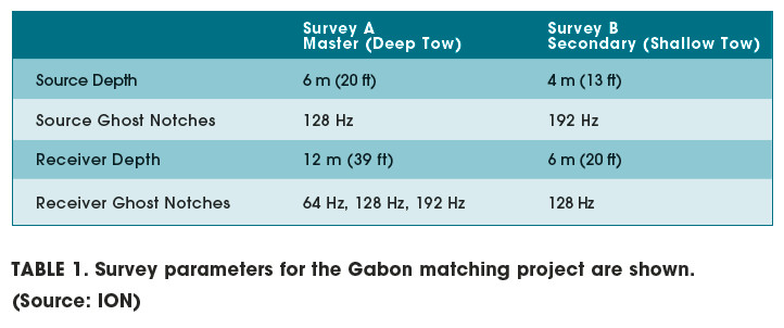
Final matching results
After successful broadband deghosting of both surveys, a least squares adaptive matching process was applied to the data to remove residual differences caused by source signature and instrument response issues. The results are shown in Figure 2. The discontinuity apparent at the butt joint of the two surveys prior to matching is largely removed on the final matched data.
Broadband processing offers a simple, robust and effective tool to match 3-D seismic surveys of various vintages regardless of tow depth. Whereas traditional approaches to survey matching have tended to level down survey resolution to the lowest common denominator, this approach has the added benefit of extending the bandwidth of conventional seismic data at the high and low end of the spectrum.

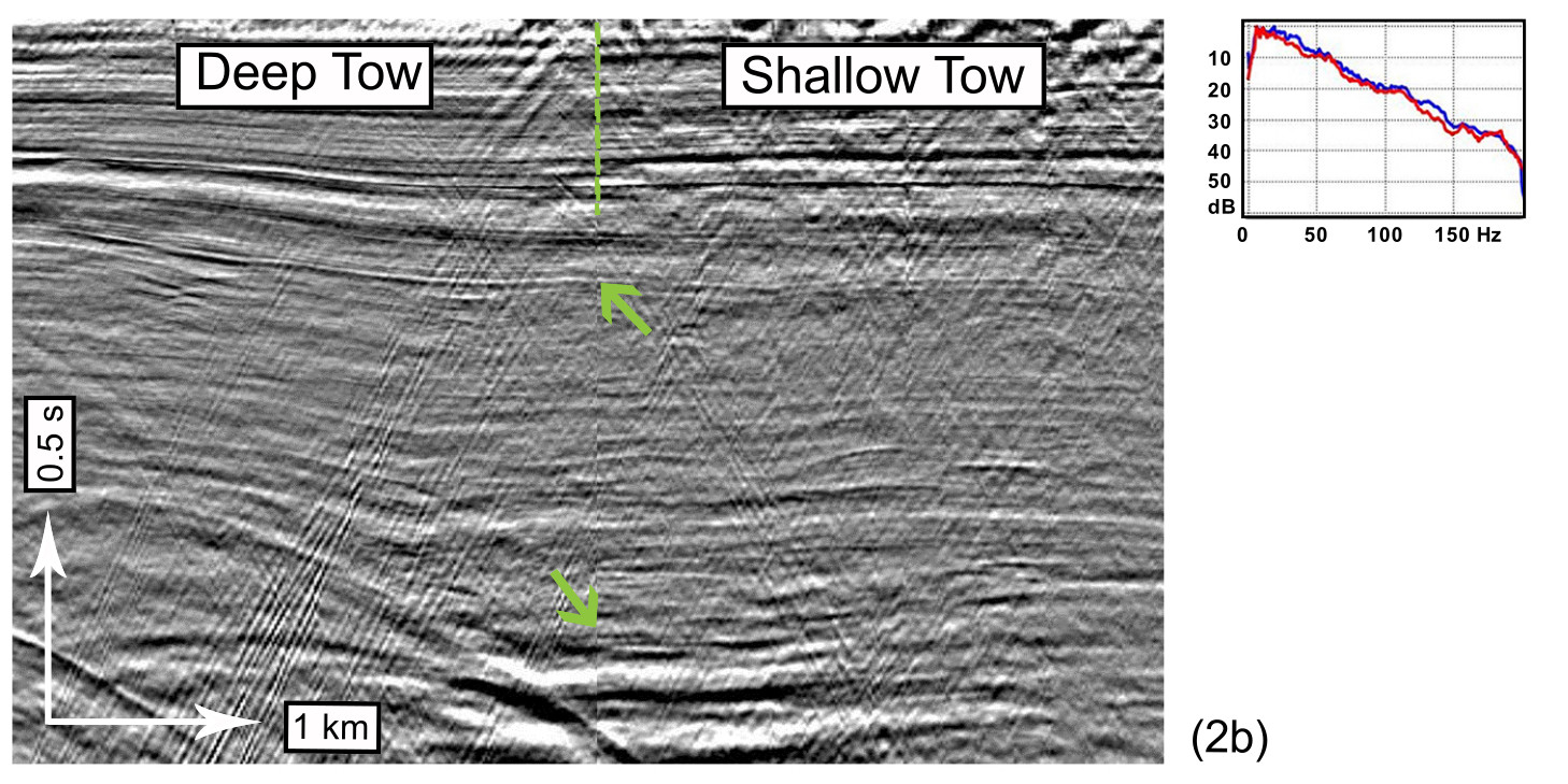 FIGURE 2. Butt-merged data from the Gabon matching project are shown (a) before matching and (b) after broadband matching. The orange dashed line in the graphs indicates the location of the merge. These data are unmigrated; hence, near-surface diffraction energy is prevalent throughout. Insets of Figure 2a show spectra indicating both shallow tow (blue line) and deep tow (red line) before deghosting. Figure 2a also shows the difficulty of matching shallow tow to deep tow before deghosting (green line). Insets of Figure 2b show shallow tow (blue line) and deep tow (red line) after deghosting and matching. Attenuation compensation has not yet been applied; hence, we observe the natural earth spectral amplitude decay in the spectra. (Source: ION)
Acknowledgements
The authors would like to thank Perenco UK holdings, in particular Brian Pim and Douglas Winstone, for their help and support throughout the project. We would also like to thank Perenco Oil & Gas Gabon and the Gabonese government for permission to use the data presented here. Finally, we thank ION for permission to publish the work and Ian Jones for his support in producing this article.
Recommended Reading

Solar Panel Tariff, AD/CVD Speculation No Concern for NextEra
2024-04-24 - NextEra Energy CEO John Ketchum addressed speculation regarding solar panel tariffs and antidumping and countervailing duties on its latest earnings call.

NextEra Energy Dials Up Solar as Power Demand Grows
2024-04-23 - NextEra’s renewable energy arm added about 2,765 megawatts to its backlog in first-quarter 2024, marking its second-best quarter for renewables — and the best for solar and storage origination.

BCCK, Vision RNG Enter Clean Energy Partnership
2024-04-23 - BCCK will deliver two of its NiTech Single Tower Nitrogen Rejection Units (NRU) and amine systems to Vision RNG’s landfill gas processing sites in Seneca and Perry counties, Ohio.

Clean Energy Begins Operations at South Dakota RNG Facility
2024-04-23 - Clean Energy Fuels’ $26 million South Dakota RNG facility will supply fuel to commercial users such as UPS and Amazon.

Romito: Net Zero’s Costly Consequences, and Industry’s ‘Silver Bullet’
2024-04-22 - Decarbonization is generally considered a reasonable goal when presented within the context of a trend, as opposed to a regulatory absolute.