
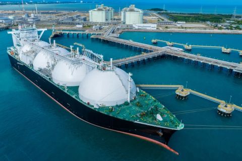
(Source: Shutterstock.com)
Proper data has always been key to making change possible. For methane emissions, the technology to detect and measure vented and fugitive methane emissions and trace them back to their sources is now mature and can be cost-effectively scaled up to cover the entire energy supply chain.
This technology hasn’t come a moment too soon. Regulators all over the world have methane in their crosshairs. First came Europe with its Methane Strategy and the European Green Deal, followed more recently by the U.S. declaration of a climate emergency. One of the first steps taken by the Biden administration has been to call on the EPA to come up with new methane rules by September 2021. Investors, end-users and the general public are all increasingly vocal in their demands that the oil and gas industry must reduce its methane footprint.
Until recently, this would have been a tall order.
For a long time, oil and gas companies had been unable to take action because of a lack of reliable and comprehensive data on methane emissions. Methane sources are widely dispersed, both in time and in space, and can range from minute leaks to massive releases. With methane being invisible and odorless, companies had to blindly rely on antiquated emission factors to self-report their emissions. Then again, regulators didn’t know any better. Emissions kept increasing.
In the last few years, a proliferation of new sensing technologies has cast a spotlight on methane emissions, and in so doing exposed the shortcomings of traditional reporting methods based on inventories and questionable emission factors. These new detection tools run the gamut from ground sensors (stationary and mobile) to aerial surveys (aircraft and drones) to tasking and monitoring satellites. Most of these sensors have a hefty price tag, though, and with very few exceptions can only perform sporadic checks at any one location. Given the multitude of potential sources and the intermittency of emissions, that can be a problem.
That’s where monitoring satellites and systems integration come in. Using the power of artificial intelligence, Kayrros has trained algorithms to extract clear, actionable signals from the raw data of monitoring satellites that watch the globe continuously. These data can pick up large methane emissions at any time anywhere in the U.S. and most of the world and help optimize tasking tools by guiding them to their targets. Kayrros combines geospatial data and input from local sensors into an integrated surveillance system that offers the best of both worlds.
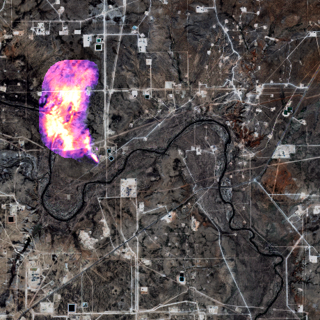
It is possible to detect, quantify and attribute emissions using high-resolution imagery.
(Source: Kayrros analysis of Szzentinel-2 data overlaid on optical image)
Kayrros fuses data from Sentinel-5P, which picks up large emissions, and high-resolution satellites such as Sentinel-2, Landsat-8 and PRISMA than can locate a methane source within 30 meters (Figure 1). Using full inversion models and input from high-resolution satellites, Kayrros can attribute large methane events down to the facility and operator level. Kayrros technology can also find additional methane sources, leveraging the lower detection threshold of hi-res satellites and the increased number of measurements. When necessary, the use of mobile sensors can help discriminate between companies operating in the same area when attributing emissions back to their source.
Armed with these tools, Kayrros scientists have tracked methane emissions across all major U.S. oil and gas production basins for the past two years. This has led to significant new lessons learned.
First, major emissions can go undetected for months. After an aerial campaign conducted by the Environmental Defense Fund in the Permian last September made headlines by spotting a large methane emission event, Kayrros analysis of satellite imagery showed that leak had actually been going on for nearly three months at a rate of up to 11 MMcf/d. Even though aerial campaigns are helpful, only monitoring satellites can systematically detect large anomalous events from the onset and help address them as soon as they occur.
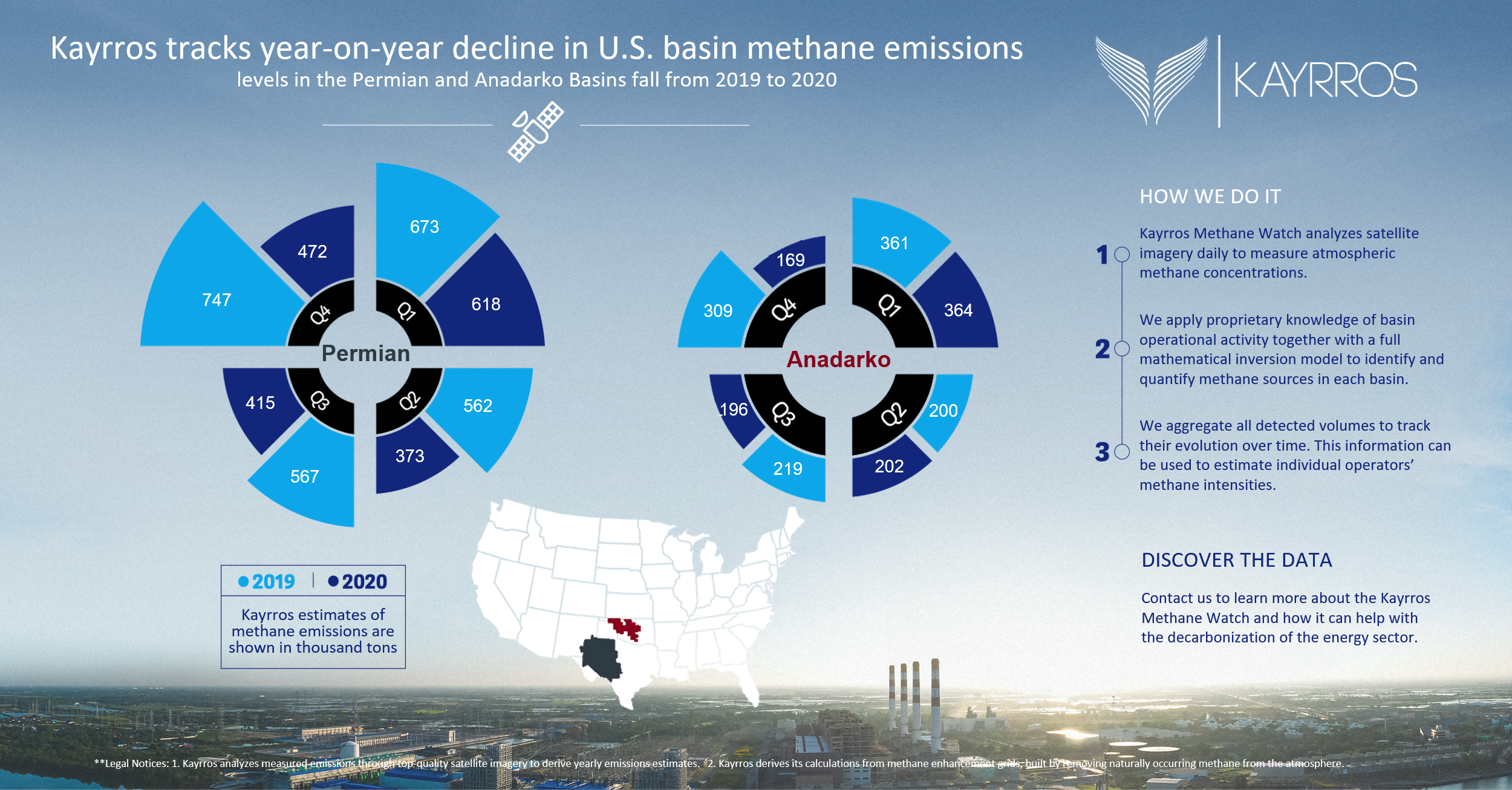
Second, while criticism of the industry’s methane footprint has been mounting, the actual volume of emissions has been decreasing over the past year. Credit goes in part to producers’ progress in controlling their emissions and to new takeaway capacity for associated natural gas that has reduced the recourse to flaring and venting. But lower emissions also reflect reduced field activity after the demand shock of the COVID-19 pandemic and the resulting price drop. Indeed, as the number of wells put into production started to rebound in the fourth quarter of 2020, so did methane emissions—a trend that continues in 2021 (Figure 2). With regulators around the world more and more concerned about climate change, the industry should prevent a return to the status quo ante and start tackling the issue.
It has all the tools to do so. Monitoring satellites now provide direct measurements at a global scale, with daily revisit time, addressing the critical issue of emission intermittency thanks to their global and continuous coverage. While punctual campaigns can detect fugitive emissions at a given moment and help identify malfunctions across the infrastructure, they do not provide a comprehensive understanding of the situation.
Making monitoring satellites the cornerstone of any methane monitoring system helps optimize the use of other technologies including tasking satellites, aerial campaigns and ground sensors, which are often more expensive, by guiding them to the right targets. Cost-effectiveness being a necessity for any robust methane monitoring system, using satellites to identify the high-risk areas before leak detection and repair (LDAR) campaigns saves capital and helps reap the low-hanging fruit of emissions abatement.
System integration helps overcome the shortcomings of the various technologies currently available, combining the global coverage of monitoring satellites and the spatial resolution and sensitivity of targeted campaigns. This combination is the only way for upstream and midstream operators to credibly show progress towards their emission targets. Although most U.S. companies are not part of the Oil and Gas Methane Partnership, using Kayrros technology would qualify them for the OGMP 2.0 framework’s highest reporting standard (Level 5), which requires asset-level direct measurements. That framework specifically highlights the potential of satellites in the independent review of companies’ reporting which the upcoming International Methane Emissions Observatory—a new institution under the umbrella of the United Nations Environment Program—is expected to lead.
A further benefit of integrated atmospheric measurements is to make it possible to benchmark U.S. emissions against those of other regions and in so doing to help level the playing field for oil and gas operators around the world.
The newfound visibility of methane emissions makes them the Achilles heel of the oil and gas sector. The U.S. LNG industry in particular might find its access to foreign markets at risk if nothing is done to clean the supply chains. But the capacity to independently and verifiably measure methane can also help the industry demonstrate progress in reducing its footprint, extend its license to operate, and ensure the long-term role of natural gas in a Net Zero economy. In a climate-conscious world, better surveillance tools combining monitoring satellites and mobile sensors can be a life saver.
Recommended Reading
API Gulf Coast Head Touts Global Emissions Benefits of US LNG
2024-04-01 - The U.S. and Louisiana have the ability to change global emissions through the export of LNG, although new applications have been frozen by the Biden administration.
ConocoPhillips CEO Ryan Lance Calls LNG Pause ‘Shortsighted’
2024-02-14 - ConocoPhillips chairman and CEO Ryan Lance called U.S. President Joe Biden’s recent decision to pause new applications for the export of American LNG “shortsighted in the short-term.”
CERAWeek: JERA CEO Touts Importance of US LNG Supply
2024-03-22 - JERA Co. Global CEO Yukio Kani said during CERAWeek by S&P Global that it was important to have a portfolio of diversified LNG supply sources, especially from the U.S.
White House Open to Ending LNG Export Pause in Push for Ukraine Aid, Sources Say
2024-04-02 - Reversing the pause could be tolerable to the White House in order to advance Ukraine aid, in part because the pause has no bearing on near-term LNG exports, the White House sources said.
Exclusive: Activists Sending 'Wrong Signal' on US LNG
2024-02-23 - Anne Bradbury, the CEO of the American Exploration & Production Council, says the Biden administration's pause on U.S. LNG export approvals sends a wrong message about the importance of LNG to the American economy and the climate, in this Hart Energy LIVE Exclusive interview.