1 Wichita, Kan.-based Ritchie Exploration Inc. scheduled two wildcats in an area on the northwestern end of the Central Kansas Uplift approximately five miles southwest of Edmond, Kan. The southern Norton County prospects are the #1-34A Circle, in Section 34-5s-23w, and the #1-35D Goeken, in Section 35-5s-23w, a mile and a quarter southeast. They're projected to respective total depths of 4,000 and 4,050 ft. for tests of the Lansing-Kansas City and Arbuckle. The #1-34A Circle is just under a mile northeast of Norham Field, a two-well pool that is currently producing about five bbl. of crude per day. The field has a cumulative production of 106,000 bbl. of oil from pays in the Lansing-Kansas City and the Arbuckle. 2 Oklahoma City independent TRI-EX Petroleum LP will evaluate the oil and gas potential in the Mississippian at a wildcat staked on the eastern flank of the Pratt Anticline, just over five miles north of Medicine Lodge, Kan. The #2 Chain Ranch, in Section 6-31s-11w in northeastern Barber County, will be drilled to a depth of 4,600 ft. The location is a mile east of Mississippian producers at about 4,325 ft. on the northeastern flank of Amber Creek South Field. Since its discovery in 1981, the 16-well pool has produced 368,000 bbl. of oil with 175 million cu. ft. of gas. 3 Norman, Okla.-independent M.E. Klein & Associates Inc. has recovered gas during a drillstem test at a wildcat a mile east of Anthony in southern Kansas' Sedgewick Basin in central Harper County. The #1 Carothers, in Section 20-33s-6w, flowed an estimated 6.68 million cu. ft. of gas per day during a 15-minute drillstem test run in the Mississippi chert. Recovery in the pipe was five ft. of condensate with no water. According to Oklahoma City-based Energas Resources Inc., holder of a 16.75% working interest in the venture, the projected 4,650-ft. prospect has porosity in excess of 30%. 4 Seeco Inc., Fayetteville, Ark., has proposed a 7,300-ft. wildcat in western Yell County, about a mile south of the town of Blue Mountain, Ark., and a half-mile north of Blue Mountain Lake. The #1-7 Albright is in previously undrilled Section 7-5n-25w, just east of the Logan County line. The drillsite is nearly two miles west-northwest of the westernmost well in Waveland Field. The #1 Alan Meyer had an initial daily potential of 1.45 million cu. ft. of gas from the Middle Atoka between 3,366 and 3,402 ft., according to IHS Energy. 5 Nadel & Gussman LLC, Tulsa, completed Oklahoma's first horizontal well tapping the Big Lime on the Nemaha Uplift, two miles southwest of Perry in southwestern Noble County. The #1-31H City of Perry, in Section 31-21n-1w, was finaled pumping 302 bbl. of 40-degree-gravity oil with 220,000 cu. ft. of gas and 55 bbl. of water daily from an openhole lateral between 5,109 and 7,313 ft. after acid treatment. True vertical depth is 4,503 ft. The well is about a third of a mile east of a three-well Big Lime pool at about 4,500 ft. in the greater Perry District. The #1-31 Wagner initially pumped 51 bbl. of 40-gravity and 37,000 cu. ft. of gas daily from perforations between 4,504-14 ft. 6 Yates Petroleum Corp., Artesia, N.M., completed an abandoned well as a deeper discovery in Mississippian nearly 10 miles west-southwest of Tatum, N.M., in northern Lea County. The #1 Slick "AZU" State Com, in Section 1-13s-34e, was tested flowing 1.6 million cu. ft. of gas per day through perforations between 13,152-77 ft. Flowing tubing pressure was gauged at 100 psi on a 48/64-in. choke. 7 About 20 miles west of Hobbs, N.M., Concho Resources Inc., Midland, completed a Wolfcamp wildcat in Lea County. The #1 Hornet State pumped 77 bbl. of oil daily, with no gas and 160 bbl. of water, through acidized perforations between 11,686 and 11,728 ft. The well was drilled to a total depth of 13,800 ft. and is in Section 3-19s-34e. The nearest previous Wolfcamp production is in Airstrip Field, 1.5 miles east. The #3 New Mexico State was completed in 1983 pumping oil from perforations between 11,664-82 ft. The 13,680-ft. well yielded just 282 bbl. of crude from that zone. 8 Burnett Oil Co. Inc., Fort Worth, completed a discovery 16 miles northeast of Stinnett in the Texas Panhandle flowing 235 bbl. of 39-gravity oil and 65,000 cu. ft. of gas per day with no water. The #1-64 Coble, in Section 1, Block G, H&GN Survey, A-64, in Hutchinson County, (RRC District 10) was tested in two intervals in the Simpson Dolomite between 9,376 and 9,436 ft. following acid treatment. Flowing tubing pressure was 200 psi on a 16/64-in. choke. Total depth is 9,958 ft. 9 H&S Production Inc., Dallas, reported two completions in the North Texas salient of the Marietta-Shermann Basin some five miles west of Pottsboro. The #1 Bryan, in Solomon Huffstetler Survey, A-535, northwestern Grayson County, (RRC 9) had an initial flowing potential of 280 bbl. of 49-gravity oil and 1 million cu. ft. of gas daily with no water from the Dornick Hills perforated between 9,324-76 ft. Flowing tubing pressure was gauged at 1,080 psi on a 14/64-in. choke. The #1 McKinney, in William Carruthers Survey, A-209, was tested on a 14/64-in. choke flowing 314 bbl. of 47-gravity oil and 1.56 million cu. ft. of gas daily with no water. Flowing tubing pressure was recorded at 1,280 psi, according to IHS Energy. Both the #1 Bryan and the #1 McKinney were fracture-stimulated. The area is one mile generally northeast of a six-well field discovered in 1953. Five of the wells tap reservoirs in the Dornick Hills between 7,100 and 8,800 ft. 10 About eight miles southeast of Post, Texas, a central Garza County (RRC 8A) discovery was completed by Halvey Energy Co., Midland. The #1 Kirkpatrick was tested flowing 31 bbl. of 41-gravity oil, 20,000 cu. ft. of gas and a trace of water daily through acidized perforations between 8,034-80 ft. in the Mississippian. Flowing tubing pressure was gauged at 45 psi on an 18/64-in. choke. The well, in Section 14, Block 5, GH&H Survey, A-689, was drilled to a total depth of 8,239 ft. 11 Ultra Oil & Gas Inc., Austin, is drilling a 13,000-ft. wildcat in southwestern Dawson County, (RRC 8A) about two miles west of Friendship, Texas. The #1 T. Calhoun is in Labor 20, League 276, Glasscock County School Land Survey, A-416. The nearest previous producer is 1.25 miles northwest in Hoske Field. The #1 Frank Freeman was completed in 1957 flowing 35.7-gravity oil from the Strawn between 11,159-73 ft. The 12,885-ft. well produced 8,606 bbl. of crude. 12 Richardson, Texas-based Colo Construction Co. Inc. has finaled a northwestern Taylor County (RRC 7B) wildcat about three miles northwest of Merkel, Texas. The #1 McDuff was tested pumping 218 bbl. of 39-gravity crude daily, with 20,000 cu. ft. of gas, through perforations in the Canyon Reef between 4,168 and 4,204 ft. It is in Section 23, Block 18, T&P Survey, A-366, just 1.25 miles south of the Jones County line. 13 Anadarko Petroleum Corp., The Woodlands, Texas, completed a new producer in Haley Field in eastern Loving County (RRC 8) nearly 20 miles west of Kermit. The #1 J.E. Haley "18," in Section 18, Block 28, PSL Survey, A-1060, was tested flowing 18.5 million cu. ft. of gas, 48 bbl. of 51.6-gravity condensate and 295 bbl. of water daily through commingled perforations between 15,050 and 15,892 ft. in the Strawn and 16,718 and 17,639 ft. in the Morrow. Both zones were fracture-treated and acidized. 14 In nonproducing Jeff Davis County (RRC 8), a West Texas wildcat is being drilled more than 10 miles east-southeast of Valentine by Brady, Texas, independent Asa Oil & Gas Inc. The #8-1 Dyer, in Section 8, Block 3, H&TC Survey, A-1738, is proposed to reach a total depth of 2,500 ft. Nearest production is 27 miles west-southwest in northwest Presidio County. 15 EOG Resources Inc., Houston, completed a wildcat on the northwestern flank of the Val Verde Basin in Terrell County (RRC 7C) in Sheffield Southeast Field, four miles south of Sheffield, Texas. The #2602 Noelke "A" flowed 3.3 million cu. ft. of gas a day through perforations in the Connell Sand between 10,272-92 ft. on a 32/64-in. choke. Flowing tubing pressure was 219 psi. The new producer was directionally drilled to a total depth of 10,386 ft. (10,300 ft. TVD). The well is in Section 26, Block B2, CCSD&RGNG Survey, A-2580, about 1.33 miles south of the Pecos County line. 16 Newfield Exploration Co., Houston, scheduled a deep Val Verde Basin wildcat in Terrell County (RRC 7C) more than 30 miles northeast of Sanderson. Plans for the #3501 Hicks, in Section 35, Block 1, TC RR Survey, A-987, call for the well to be drilled to a total depth of 15,000 ft
Recommended Reading
US Drillers Add Oil, Gas Rigs for Second Week in a Row
2024-01-26 - The oil and gas rig count, an early indicator of future output, rose by one to 621 in the week to Jan. 26.

Second Light Oil Discovery in Mopane-1X Well
2024-01-26 - Galp Energia's Avo-2 target in the Mopane-1X well offshore Namibia delivers second significant column of light oil.

CNOOC Sets Increased 2024-2026 Production Targets
2024-01-25 - CNOOC Ltd. plans on $17.5B capex in 2024, with 63% of that dedicated to project development.

E&P Highlights: Jan. 29, 2024
2024-01-29 - Here’s a roundup of the latest E&P headlines, including activity at the Ichthys Field offshore Australia and new contract awards.
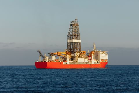
Seadrill Awarded $97.5 Million in Drillship Contracts
2024-01-30 - Seadrill will also resume management services for its West Auriga drillship earlier than anticipated.