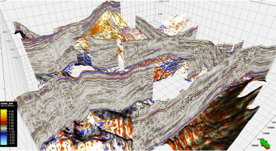
FIGURE 1. Several arbitrary lines of the mega-merged seismic show the stratigraphy variation across the basin. (Source: ION Geophysical)
[Editor's note: A version of this story appears in the June 2020 edition of E&P. Subscribe to the magazine here. It was originally published June 1, 2020.]
The tectonics of Argentina’s Neuquén Basin has been studied in detail by many authors. The extensional period between the Upper Triassic and Lower Jurassic resulted in a system of northwest-to-southeast-oriented half grabens; and a later compressive-transgressive period from the Upper Jurassic resulted in a system of mainly east-to-west reverse and transgressive faults. Trans-tension related to this period adds structural complexity to the area. Similarly, the stratigraphy and facies of the Vaca Muerta Formation have been studied in detail.
The mega-merged 3D seismic clearly shows the characteristics and geometries that make the interpretation of strata stacking patterns, their stratigraphic relations and the interpretation of internal configurations (e.g., onlaps and downlaps) much easier than before. From the southeast to northwest, it can be observed that the major architectural trends from proximal basin margin facies through central basin settings and into distal basin floor facies (Figure 1).
A total of 14 wells with a relatively complete log set were identified for the petrophysical analysis. Given the complex mineralogy of the Vaca Muerta Formation, a statistical mineral analysis was used. The method included log response equations for several tools simultaneously to obtain the mineralogy, fluid content and total porosity. Gamma ray, density, neutron and compressional sonic and clay volume estimated from normalized gamma ray were used as input curves for all the wells analyzed. The results show the Vaca Muerta is predominantly limestone, with some marl or siltstone interbeds. Kerogen is mainly deposited in the lower Vaca Muerta formation with a maximum 12% of volume. Total porosity can reach up to 25% at the lower Vaca Muerta. The interpretation was calibrated to core data.
Post-stack seismic inversion
Three key horizons around the target formation, Top B, Vaca Muerta and Todrillo, were interpreted for well tie, background model building and inversion. The seismic data quality is relatively good in the target zone (Vaca Muerta to Todrillo). However, this seismic volume comes from different surveys, and the spectra of different surveys are not quite balanced, which may affect the inversion results.
All the wells inside the seismic survey are tied with seismic before inversion. The Gardner equation is used to predict the density log for the wells without the density measurement.
The inversion results show a relatively good match with the wells. The lower Vaca Muerta shows relatively low acoustic impedance (AI), which is a typical Kerogen response. The inverted AI volume, together with the well logs interpretation results are then later integrated using the geologic modeling technique for detailed rock property estimation.
Geomodeling
A geocellular model represents the reservoir geology and the vertical and horizontal variation of the reservoirs in detailed log scale. The model incorporates the 3D structural framework, the conceptual depositional system (facies) and reservoir sublayers. The reservoirs and formations above and below the reservoirs, constraining the structural model, are divided first into zones and later into thin layers and into a 3D mesh of cells until the cells with thickness of rocks can simulate the reservoir properties. For each cell, just one lithofacies type can be assigned, but it can storage multiple reservoir properties.
The cells cut by wells are populated with facies and reservoir properties, using averaging methods such as arithmetic mean. The values of facies and a cell’s properties loaded from well logs are distributed or interpolated through all the cells of the geocellular model based on the spatial continuity concepts. The spatial distribution is carried out by applying geostatistics, which includes data analysis and deterministic and stochastic algorithms. Sequential Gaussian Simulation is applied to create heterogeneity-property volumes honoring input/output of local data, histograms and variograms. Rock physics constraints and a co-located cokriging method were used to honor the well data and seismic inversion result simultaneously. Finally, the geocellular model was populated with petrophysical and elastic rock properties that can be used to assess, develop and manage the reservoir.
Two types of geomodels are created: one using well data only, and the other using both seismic and well data. By comparing two geomodels, significant values of applying seismic data in delineating the 3D rock properties are demonstrated. From the basin-scale geomodels, it was observed that the highest total organic rich and high-porosity zone is located in the lower Vaca Muerta of the southeastern part of the basin.
Conclusions
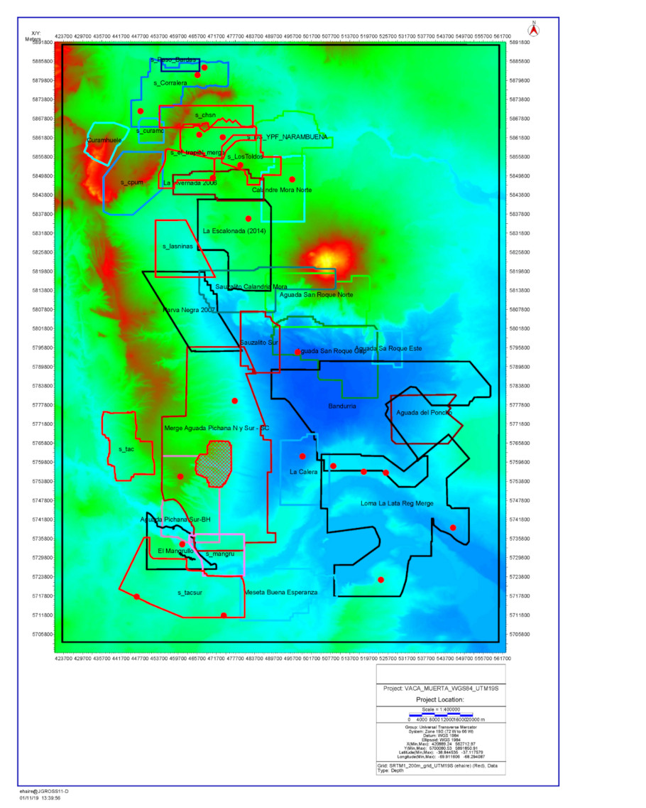
An integrated study of the Vaca Muerta Formation, Neuquén Basin, was performed using mega-merged 3D seismic data covering about 12,000 sq km to estimate the kerogen, porosity and lithology (Figure 2). Four key tasks were included in this project: regional structural and stratigraphic interpretation, petrophysical analysis, post-stack inversion, and geocellular model building. 3D structures of the Vaca Muerta are revealed from the mega 3D interpretation. Regional scale stratigraphic features and lateral transitions have been evidenced from a single seismic volume for the first time.
Geocellular modeling combines the well log data and inverted AI volume together with the geological information to produce a detailed description of the geological deposition and kerogen distribution. The basin-scale geocellular model provides a powerful tool for sweetspot identification during the exploration phase and reserve estimation and well planning during field development.
Recommended Reading
Chevron’s Tengiz Oil Field Operations Start Up in Kazakhstan
2024-04-25 - The final phase of Chevron’s project will produce about 260,000 bbl/d.
Rhino Taps Halliburton for Namibia Well Work
2024-04-24 - Halliburton’s deepwater integrated multi-well construction contract for a block in the Orange Basin starts later this year.

Halliburton’s Low-key M&A Strategy Remains Unchanged
2024-04-23 - Halliburton CEO Jeff Miller says expected organic growth generates more shareholder value than following consolidation trends, such as chief rival SLB’s plans to buy ChampionX.

Deepwater Roundup 2024: Americas
2024-04-23 - The final part of Hart Energy E&P’s Deepwater Roundup focuses on projects coming online in the Americas from 2023 until the end of the decade.

Ohio Utica’s Ascent Resources Credit Rep Rises on Production, Cash Flow
2024-04-23 - Ascent Resources received a positive outlook from Fitch Ratings as the company has grown into Ohio’s No. 1 gas and No. 2 Utica oil producer, according to state data.