Since the launch of the first dual-sensor towed streamer system in 2007, PGS has completed a fleetwide rollout of this revolutionary technology. The introduction of this streamer technology triggered a new demand for broader bandwidth seismic data and industrywide awareness of its geophysical benefits for both frontier exploration and production monitoring. It resulted in the rapid development of new acquisition and processing technology and resulted in changes to seismic vessel design and equipment. Today broadband benefits and a deghosting methodology using up- and down-going wavefields are routinely exploited throughout the seismic value chain, including imaging and reservoir characterization.
Ghost removal, deeper tow
In today’s challenging E&P environment, petroleum geoscientists must detect and properly image increasingly complex reservoirs by resolving the fine detail of ever smaller hydrocarbon accumulations. High-quality seismic data plays a key role in this effort to reduce overall E&P risk. Critically, the industry needs to enable the identification and delineation of leads and prospects based on prestack seismic data and to quantify key reservoir properties to successfully separate lithology-fluid facies.
It is well understood that data richer in both low- and high-frequency information provides optimal input for improved reservoir delineation and high-resolution imaging and that improvements in the signal-to-noise ratio (S/N) of the recorded data could be made by towing the seismic equipment deeper.
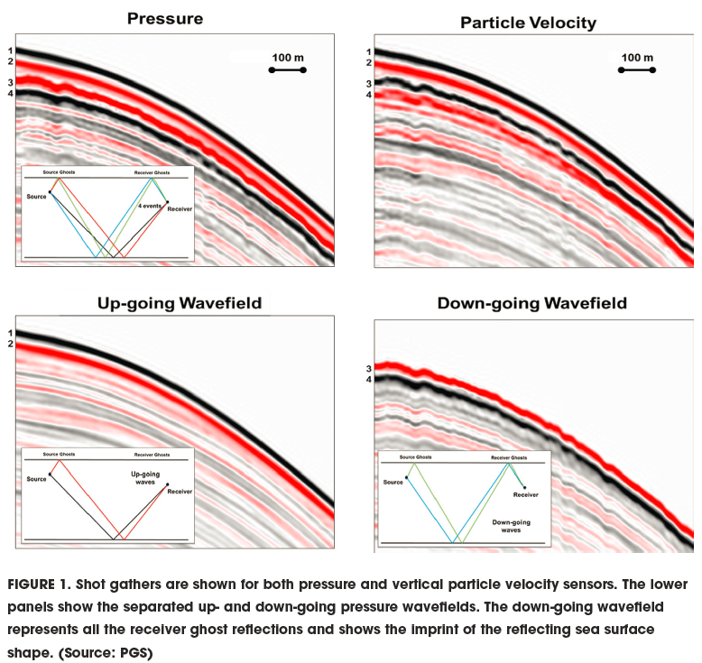
Traditionally, streamer tow depths have been limited to between 7 m and 10 m (23 ft and 33 ft) to avoid attenuation of high-frequency content by the so-called ghosting effect. Ghost notches are created when a range of frequencies are attenuated through destructive interference between seismic energy directly reflected from the subsurface and ghost reflections of the same energy reflected at the sea surface directly above the source or receiver equipment.
Dual-sensor streamer technology has enabled the industry to overcome the fundamental receiver ghost problem, increasing the seismic bandwidth and providing better resolution for interpretation. As the ghost is robustly and accurately removed using the complementary recordings of the two sensors (Figure 1), the receivers can be towed deeper, improving the S/N, specially at the low-frequency end of the seismic bandwidth. This improved low-frequency content enhances the quality and accuracy of seismic inversion as well as reservoir characterization.
Flexible, dynamic tow depth
While deeper tow enables the recording of more low-frequency signal energy, it can increase operational complexity. Increasing and maintaining streamer depth in a 3-D spread is challenging. Deeper front ends typically require additional downward forces and create higher drag.
However, dual-sensor towed-streamer technology has no theoretical requirement to tow flat. The deghosting process is geophysically accurate and robust even with cable depth variations (uncontrolled or controlled). Streamer depth profiles can therefore be adjusted to optimize seismic data quality without sacrificing acquisition efficiency, allowing nominal streamer depths of 25 m to 30 m (82 ft to 98 ft) to be combined with shallower front-end tows to minimize drag.
Modern depth steering devices enable rapid adjustment of tow depths during ongoing surveys with no negative impact on data quality and without complicating subsequent signal processing and imaging procedures. Tow depth can be adjusted to reduce noise from swell, to avoid shallow obstacles like pipelines and fishing traps or to adapt to local currents and thermoclines.
New class of seismic vessels
Increasing the tow depth has reduced the significance of swell noise created by surface wave action and has made it possible to acquire seismic data in weather conditions that would have stopped traditional shallow-tow surveys. However, although high-quality data can now be recorded in more marginal weather conditions, operational safety as well as the well-being of the crew remain a priority.
All this was considered in the design of the latest Titan-class Ramform vessels. The stern was widened from 40 m to 70 m (131 ft to 230 ft), allowing up to 24 streamers to be towed simultaneously and minimizing wave-induced tug noise. Larger deflectors enable spread widths up to 1,700 m (5,577 ft), permitting 18 streamers to be towed at a 100-m (330-ft) separation. The Titan-class Ramform has two workboats in cradles located at the stern, where wave motion is smallest, enabling safe deployment and retrieval with minimum human and equipment risk.
The greater size of this new vessel class also increases operational efficiency. The increased space and the comfort benefits team work and interaction. Working offshore becomes safer and less stressful.
Noise mitigation strategies
Seismic operations in temperate waters such as offshore West Africa or Brazil are exposed to barnacle growth on in-sea equipment. On seismic streamers this barnacle infestation can significantly increase drag, potentially impacting streamer separation and increasing fuel consumption. Barnacles also generate undesirable noise.
With the launch of the dual-sensor streamer technology, particular focus has been put on developing a comprehensive barnacle mitigation strategy.
Historically, manual cleaning and scraping was the only effective measure to address these problems. Automated in-sea streamer cleaning units have since been engineered that enable continuous proactive barnacle mitigation. The units are deployed at the streamer front and retrieved at the tail. The devices are autonomous, powered by the movement of the seawater relative to the streamers and pass positioning units without human interaction. Cleaning continues during the recording of seismic data.
Time-lapse (4-D) monitoring
Demonstration of the dual-sensor technology’s 4-D prestack and post-stack compliance was an important milestone for the industrialization of this new streamer platform. The full 4-D backward compatibility of the system and other fundamental benefits were validated in a field trial in 2009.
By late 2015, 17 dual-sensor baseline and monitor surveys had been acquired. With time-lapse, reservoir characterization and high-resolution imaging objectives in mind, all of these 4-D acquisition projects made use of deep-tow high-density spreads.
Utilizing ghost-free deep-tow data, the first dual-sensor 4-D survey has produced repeatability levels previously unachieved by any hydrophone-only streamer system, enabling the detection of even smaller production effects at the reservoir level.
Improving near-surface imaging
In shallow water illumination holes can appear at swath boundaries on 3-D towed streamer surveys due to a lack of near-offset data. The missing near offsets create a footprint in the shallow image and might hinder quality control of migration velocities. The ability to conduct important amplitude vs. offset/amplitude vs. azimuth (AVO/AVA) studies is limited by the same effect.
After dual-sensor wavefield separation-based deghosting, each receiver location throughout the streamer spread becomes a “virtual” source that uses energy reflected from the sea surface to provide the missing near-surface information. The shallow overburden can now be imaged seamlessly, complemented by the AVO/AVA analysis facilitated by the virtual source concept. This approach to imaging using separated wavefields also can be a driver for acquisition efficiency. Traditional survey planning considerations to maximize spread width and sail line separation are based on primary reflections only and may thus be relaxed by taking sea surface-reflected energy into account.
Rock property estimation
Dual-sensor towed-streamer data have been successfully used for prestack analysis in a multitude of geological settings to derive reliable rock physics attributes (Figure 2). Robust quantitative interpretation workflows have demonstrated that the richer content of prestack-compliant low-frequency information in true broadband dual-sensor data permits accurate prediction of lithology/fluid distribution and even porosity.
Blind-well analysis has demonstrated the accuracy of the rock property prediction, establishing the value of dual-sensor data for de-risking leads and prospects through improved reservoir characterization in areas of limited well control.
Recommended Reading

Sempra Targets Summer 2025 for Commercial Start of ECA LNG Phase 1
2024-03-06 - Sempra is targeting the summer of 2025 as the commercial operations date for its 3.25 mtpa (0.43 Bcf/d) nameplate capacity Energía Costa Azul LNG Phase 1 project, located in Ensenada in Baja California, Mexico.

Heard from the Field: US Needs More Gas Storage
2024-03-21 - The current gas working capacity fits a 60 Bcf/d market — but today, the market exceeds 100 Bcf/d, gas executives said at CERAWeek by S&P Global.

FERC Approves Extension of Tellurian LNG Project
2024-02-19 - Completion deadline of Tellurian’s Driftwood project was moved to 2029 and phase 1 could come online in 2027.

ConocoPhillips CEO Ryan Lance Calls LNG Pause ‘Shortsighted’
2024-02-14 - ConocoPhillips chairman and CEO Ryan Lance called U.S. President Joe Biden’s recent decision to pause new applications for the export of American LNG “shortsighted in the short-term.”
Rystad Sees Little Support for Henry Hub in Coming Weeks
2024-01-26 - Rystad Energy sees little support for Henry Hub prices in the U.S. as dry gas production rises after the Jan. 17 Arctic freeze that impacted all of the Lower 48 states.