
Source: Shutterstock.com
Presented by:
![]()
Editor's note: This article originally appeared in the May issue of E&P Plus.
Subscribe to the digital newsletter here.
The outer Campos Basin remains an underexplored domain of the prolific Brazilian hydrocarbon provinces exemplified by super-giant discoveries in the adjacent Santos Basin and in the inner segment of the Campos Basin.
The growing interest in extending the various proven petroleum systems and associated play types into the external Campos Basin is consequentially being answered by PGS with an ongoing non-exclusive program of high-quality GeoStreamer 3D multisensor seismic acquisition, including the recording of gravity and magnetic data. This multiyear program will aid industry evaluation of newly offered acreage, extending the exploration opportunities of the deepwater Campos Basin.
Exploration potential of the post-salt and the prolific presalt section will be presented here in light of the imaging results and the forthcoming Brazil bid round.
New seismic data for Campos Basin exploration
PGS recently completed the acquisition of 15 600 sq km of multisensor 3D seismic data over the deepwater section of the outer Campos Basin offshore Brazil. New data are combined with existing 3D seismic data using multi-azimuth processing to enable optimal imaging particularly of the presalt architecture in this prolific hydrocarbon basin. The program is in line with the forthcoming licensing rounds (Concession Round 17 and 7th Sharing Round), aligns with the demand for optimized seismic imaging of the presalt reservoirs and illuminates the underlying petroleum systems.
In addition, it provides the industry with reliable seismic imaging for appropriate exploration risk mitigation and potential drilling hazard assessment in this emerging deepwater basin.
Campos Basin subsurface setting
The survey covers the entire outer passive margin section of the Campos Basin including large parts of the outboard allochthonous salt edge (Figure 1). Based on the character of the salt architecture and associated structural settings, four major domains have been established. Gravity-driven, thin-skinned tectonics along the basin’s subsiding passive margin, caused prolonged salt movements, which contributed to the formation of these salt structural domains (Figure 1).
PGS Campos Basin 3D Seismic Program
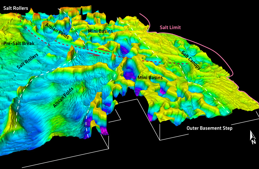
An inboard area called the Salt Roller domain refers to the updip zone of post-rift extension that affected the Aptian evaporites and overlying Albian carbonates.
Extension is evident by a network of listric normal faults rooting into the regional decollement along the base of the evaporites. The domain name refers to the predominant salt concentration in triangular-shaped bodies at the footwall of the extensional faults.
The most prolific and giant oil and gas fields of the Campos Basin (e.g., Roncador, Marlim, Jubarte, etc.) reside in the Upper Cretaceous clastic sequences above this salt domain, which might be sourced, at least partially, from presalt hydrocarbon kitchens. Amplitude analysis within the program area revealed similar evidence for hydrocarbon reservoir potential within the postsalt sequence. It further includes promising presalt discoveries near the inner high of the rift system. These are characterized by well-imaged, sag-phase, layered, depositional signatures on-lapping onto tilted fault blocks related to the Lower Cretaceous rifting stages of the margin.
The sag-phase basins contain the rich Barremian source rock sequences while the structural highs are critical for the deposition of the prolific presalt reservoirs, comprising high porosity shallow-water carbonate buildups. The latter are predominantly formed of high energy marine to lacustrine Coquina facies limestones, stromatolitic mounds and sometimes travertine. The drilled sag-phase signature extends beyond the inner high and an adjustment regional ramp, which drops the base of the evaporate sequence over a series of rift-related normal faults (Figure 1).
The slightly deeper outer area is the focus of the new 3D GeoStreamer survey, offering several well imaged hydrocarbon exploration targets underneath the Aptian evaporites. The gentle presalt morphology with structural highs next to stratified sag-basin fills, continues underneath the subsequent two outer salt domains and opens additional exploration running room, where the newly acquired 3D seismic dataset will support exploration and drilling risk mitigation.
Presalt objectives under the Albian Folds and Salt Mini Basins
The Albian Folds domain (Figure 1) is characterized by an intense corrugation at the top of the Aptian evaporite sequence and affects the Albian carbonates. The fold structures quickly dampen against intra-formational unconformities within the Albian carbonate sequence and are caused by early shortening instabilities that appear to be linked to extensional fragmentation of the same sequence at the updip salt roller domain. A line of salt walls, which document the prolonged salt inflation (Figure 1), today separates both domains. Salt movement becomes the dominant condition in the adjacent Mini Basin domain where salt walls and reactive diapirs separate an array of deep mini basins filled with post salt sediments (Figure 1). A few salt bodies transition into active diapirs and reach shallow levels below the mud line, while some of the mini basins are grounded with their Albian sequence against the presalt formation.
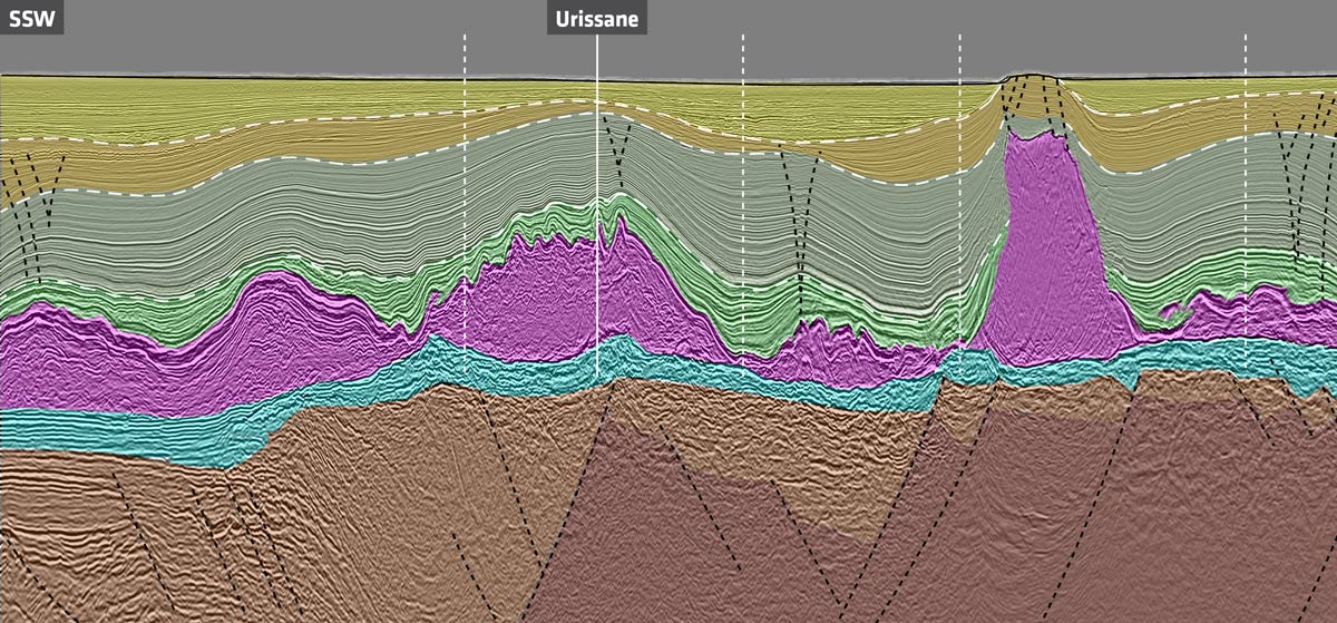
Underneath the Mini Basin domain, an approximate North-South trending outer structural high reveals a series of potential presalt reservoirs, more than a half dozen locations already identified by the industry as potential drilling targets (Figure 2). A recent presalt test by Petrobras and partner Exxon Mobil on the Urissane prospect is expected to confirm a working petroleum system and the extension of the presalt play concept into the deepwater sector of the Campos Basin. Petrobras filed a hydrocarbon oil show report to the Brazilian regulator ANP in early first-quarter 2021 on this first outer Campos Basin presalt well.
The Outer High and the edge of the salt basin salt kinematics
The outer high forms the proximal shoulder of a l basement graben, underneath thick salt accumulations of the Mini Basin domain (Figure 2). The graben’s distal shoulder images a significant, 1,000-m to 2,000-m basement step that is fragmented by NE-SW trending sinistral transfer fault zones. This basement step likely marks the limit of the passive margin rift system and reveals frequent magmatic features such as sill-like intrusions along the salt base. Beyond the outer basement step the evaporites form an allochthonous salt canopy (Figure 1) that gradually climbs over (possible) Upper Cretaceous deep marine sediment sequences. Analog subsalt plays are well described from other salt basins such as the Northern Gulf of Mexico where significant subsalt discoveries are documented. A portion of this area is included in the acreage offering by ANP in the upcoming Brazil 17th Bidding Round and is covered by the new 3D program.
The geophysical data cover the complete salt kinematic system from the proximal, updip extension to distal compression and salt inflation, including salt mobilization into canopies at the outermost section of the passive margin. It also illuminates the interaction with the underlying rift architecture. The resulting salt kinematics have several implications for hydrocarbon exploration including the top seal assessment for underlying hydrocarbon reservoirs, while the salt architecture impacts seismic wave propagation and therefore the fidelity of the presalt imaging of the reservoirs and their associated petroleum systems.
Advanced seismic technology for presalt imaging
The new data offers a step change in image quality of the emerging Campos presalt play.
Full waveform inversion driven depth velocity modeling of the post-salt, layered evaporate (salt) and presalt sections has provided more accurate velocity model updates by leveraging the full seismic wavefield (reflections and refractions) recorded in these long-offset (10 km) multi-azimuth data. Improved velocity model accuracy affords improved image quality, illumination and depth accuracy of the subsurface structures found within the presalt play. The results will support any future exploration drilling and subsequent reservoir characterization.
Recommended Reading

Chord Buying Enerplus to Create a Bakken Behemoth
2024-02-22 - Chord Energy said Feb. 21 it will acquire Enerplus Corp. for nearly $4 billion in a stock-and-cash deal to potentially create the largest producer in the Williston Basin.

Williston Warriors: Enerplus’ Long Bakken Run Ends in $4B Chord Deal
2024-02-22 - Chord Energy and Enerplus are combining to create an $11 billion Williston Basin operator. The deal ends a long run in the Bakken for Enerplus, which bet on the emerging horizontal shale play in Montana nearly two decades ago.
CERAWeek: Exxon Mobil CEO Says Not Trying to Acquire Hess
2024-03-18 - CEO Darren Woods said Exxon Mobil is trying to secure preemption rights over Hess Corp.'s Guyana assets in its dispute with Chevron, not buy the company itself.

Talos Energy Sells CCS Business to TotalEnergies
2024-03-18 - TotalEnergies’ acquisition targets Talos Energy’s Bayou Bend project, and the French company plans to sell off the remainder of Talos’ carbon capture and sequestration portfolio in Texas and Louisiana.

ConocoPhillips CEO Ryan Lance: Upstream M&A Wave ‘Not Done’ Yet
2024-03-19 - Dealmaking in the upstream oil and gas industry totaled $234 billion in 2023. The trend shows no signs of slowing, ConocoPhillips CEO Ryan Lance said at the CERAWeek by S&P Global conference.