Learn more about Hart Energy Conferences
Get our latest conference schedules, updates and insights straight to your inbox.
1 The eastern Gulf of Mexico is attracting a lot of attention these days as several companies have deepwater wildcats in the works in the DeSoto Canyon area. Ocean Energy Inc., now part of Devon Energy Co., Oklahoma City, has reached total depth at its Tuscany prospect in DeSoto Canyon 180. The #1-OCS-G-23493 is in 7,030 ft. of water. If all goes well, the company could drill six wells in blocks 180 and 224, immediately south. The nearest production is from King's Peak Field, 10 miles west-northwest. South of the Tuscany well and slightly west, Marathon Oil Co., Houston, has filed an initial plan of exploration for its Stegodon prospect in DeSoto Canyon 354 in 7,551 to 7,609 ft. of water. The nearest production is two blocks northwest at the Aconcagua Field in Mississippi Canyon 305. Still farther south in DeSoto Canyon 621, Anadarko Petroleum Corp., Houston, is drilling the #1 OCS-G-23529, the first of five wells proposed for the tract. Amerada Hess has filed an exploration plan for up to four wells in Block 620, immediately west, and Shell Offshore plans as many as five wells immediately east in Block 622, according to IHS Energy. 2 Moon-Hines-Tigrett Operating Co., Ridgeland, Miss., completed a discovery flowing 401,000 cu. ft. of gas in the northeastern corner of Chickasaw County, Miss. The company's #1 Smith Estate 11-8, in Section 11-12s-5e, was tested through two acid-treated intervals in Carter between 1,674-99 ft. The well gauged 500 psi of flowing tubing pressure through a 12/64-in. choke. The company drilled the well to 3,050 ft., but planned to deepen it to 3,100 ft. The closest production is more than two miles south-southeast in Sugar Run South Field. 3 S. Lavon Evans Jr. Operating Inc., Laurel, Miss., has reached total depth at 5,105 ft. at the #1 Weyerhaeuser 4-1 well in Lamar County, Ala. The well, in Section 4-17s-16w, is part of an exploration program about three miles east of the Mississippi state line. The well is a third-mile south-southeast of the company's #1 Weyerhaeuser 33-15, in Section 33-16s-16w, which flowed 320,000 cu. ft. of gas per day from Carter between 4,418-30 ft. 4 Muskegon Development Co., Mount Pleasant, Mich., plans a 10,500-ft. wildcat in a nonproducing township in southwestern Oscoda County, Mich. The company's #1-8 USA & State-Big Creek, in Section 8-25n-1e, will look for pay in Prairie du Chien. There is no drilling to similar depths anywhere in the vicinity of the well. It is nearly seven miles west of an Ordovician gas-condensate discovery in Church Lake Field in Section 16-25n-2e. In that field, the #1-16 USA-Big Creek was completed in 1988 flowing 1.8 million cu. ft. of gas, 22 bbl. of condensate and 66 bbl. of water a day from Glenwood and St. Peter between 9,981 and 10,004 ft., but the Prairie du Chien zones between 10,032-62 ft. were squeezed off after fracturing and acidizing. 5 A wildcat aimed at Devonian Richfield about nine miles northeast of Lake City, Mich., has been scheduled by Sturgeon Point Development Co., Traverse City. The company's #C2-31 Davidek is in Section 31-24n-6w, Missaukee County, about 4.5 miles south of production from a similar depth in Cannon Creek Field. The Richland pool in that field was started with the #1-6 State-Norwich, which tested at 65 bbl. of oil and 105,000 cu. ft. of gas a day, according to IHS Energy. 6 Pioneer Oil Co. Inc., Lawrenceville, Ill., has scheduled a second wildcat in St. Clair County, Ill., to test zones through Trenton at 3,000 ft. The #1 Hagist, in Section 10-1s-6w, is in the western Illinois Basin about 2.5 miles southeast of Mascoutah. It also plans to drill the #1 Kronemeyer to the same depth in Section 9-1s-6w. Nearby gas production in St. Libory Field comes from Cypress, Benoist, Aux Vases and Silurian zones shallower than 2,000 ft. 7 A southern Illinois wildcat about a mile north of Sesser Consolidated Field is in the works for DeMeir Oil Co., Mount Vernon, Ill. The company scheduled its #1 Allen to 2,900 ft. in Section 24-6s-1e, northwestern Franklin County, to look at formations through McClosky. Production from Sesser Consolidated Field, which is on an anticlinal feature, comes from seven Mississippian zones from Cypress through St. Louis at about 3,000 ft. and from the Devonian Clear Creek at 4,400 ft., according to IHS Energy. 8 Scott and Jerilyn Picha, Gaston, Ind., have scheduled the #1 Picha wildcat in Section 2-21n-11e, Delaware County, Ind. The well is planned to 1,000 ft. to test Trenton. The #1 Picha is 4.25 miles northwest of Trenton Field, which produces from Trenton and 1.5 miles southeast of the town of Gaston. 9 Bakerwell Inc., Westerville, Ohio, plans a wildcat five miles southwest of Gallipolis in Gallia County, Ohio. The company's #1 Jarrell Unit, in Section 10 of Mercerville Quad, Harrison Township, is aimed at Trempealeau at 7,300 ft., according to IHS Energy. 10 Chemung County, N.Y., will host two wildcats. Columbia Natural Resources Inc., recently purchased by Triana Energy Holdings, Charleston, W.Va., will redrill to 10,316 ft. looking for gas at its #624537-A Schmidt, in Section H, Erin Quad, Erin Township, nearly seven miles northeast of an unnamed Oriskany Field. The original 2001 well, the #624537 Schmidt, was completed in Trenton-Black River at 10,410 ft. The other wildcat planned for the county is the #1 Curren, scheduled to Tully by East Resources Inc., Wexford, Pa. The well is in Section H, Seeley Creek Quad, Southport Township, just over 10 miles southwest of an unnamed field that produces from Tully. 11 A couple of wildcats have been staked by Belden & Blake Corp., North Canton, Ohio, looking for deep gas in the Hamilton formation in Broome County, N.Y. The company's #1 Olson will be drilled to 9,750 ft. in Section H, Chenango Forks Quad, Fenton Township, nearly 17 miles south of Hamilton production in Genegantslet Field. The other wildcat is the #1-A Butkowsky, targeting the same formation at 10,150 ft. That well also is in Section H, Chenango Quad, but it's in Kirkwood Township. 12 Interstate Gas Marketing Inc., Indiana, Pa., has scheduled a wildcat northeast of Culver in Cambria County, Pa. The company's #1 B. Lowmaster Unit, in Cambria Township, Cambria Quad, will go to 9,000 ft. to test Huntersville. The well is more than a mile north-northeast of a 1972 gas well drilled in Pindleton Field. That 8,538-ft. well was completed open hole in Huntersville/Oriskany, according to IHS Energy. 13 Fayette County, Pa., has attracted a lot of attention lately, and Atlas Resources Inc., Moon Township, Pa., has led the activity. The company's #1 Seitz will reach for Devonian at 4,000 ft. in Section I, Fayette City Quad, Jefferson Township, less than a mile east of White Oak, Pa., and 1.25 miles northwest of McKeesport Field. In the same township, the #3 Lilley is scheduled for Warren at 4,000 ft. in Section H, and the #1 Dominiak will drill to Bayard at 4,000 ft. in Section F. In other action, the company plans the #2 E& N Land wildcat to Huntersville at 5,000 ft. in Section A, New Salem Quad, Redstone Township, about 4.5 miles southwest of Seven Springs, Pa. In the same quad and township, it will also drill the #2 Teslovich to the Fifty Foot Sand at 5,000 ft. 14 Four wildcats are on the books for drilling in Wetzel County, W.Va. Alma-based Dac Corp. plans the #1 Evans and the #2 Evans, both to Speechley at 3,900 ft. in Church District, Hundred Quad. The wells are more than two miles northeast of Big Run-Burch Field, which produces from Big Injun. Additionally, Dynatec Energy Inc., Salt Lake City, Utah, will drill the #LL-1 Dailey, also in Church District, Hundred Quad. The coalbed-methane well is scheduled to Pittsburgh coal at 870 ft. Finally, Berry Energy Consultants & Managers, Clarksburg, W.Va., wants to drill its #B748 Scyoc & Hillberry to Gordon at 3,650 ft. in Stonewall District, Kiahsville Quad, approximately 13.5 miles north of Kermit, W.Va. 15 West Virginia's Kanawha County is seeing some activity by a group of Charleston-based operators. Columbia Natural Resources Inc. plans a 4,800-ft. Devonian test at its #825151 Leo G. & Ruby Kopelman et al., in Cabin Creek District, Cedar Grove Quad, about a mile south of Campbell Creek Malden Field, which produces from Weir. Martin Twist Energy Co. LLC has scheduled two 5,500-ft. Devonian tests: the #1 Fowlkes and the #2 Fowlkes. Both are in Union District, Big Chimney Quad, about 3.75 miles northeast of the city limits of Charleston. Also, Northstar Energy Co. will drill the #BW-5 Berwind-Winifrede in Cabin Creek District, Belle Quad, about 6.5 miles south of Chesapeake, W.Va. 16 Sundown Energy Inc., Dallas, has permitted the #1 Ruth Brady et al. to Corniferous at 1,499 ft. in Logan County, Ky. The well is in Section 3-E-31e, Lewisburg Quad, some 5.5 miles south of the town of Lewisburg.
Recommended Reading
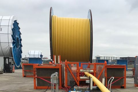
Exxon Mobil Guyana Awards Two Contracts for its Whiptail Project
2024-04-16 - Exxon Mobil Guyana awarded Strohm and TechnipFMC with contracts for its Whiptail Project located offshore in Guyana’s Stabroek Block.

Deepwater Roundup 2024: Offshore Europe, Middle East
2024-04-16 - Part three of Hart Energy’s 2024 Deepwater Roundup takes a look at Europe and the Middle East. Aphrodite, Cyprus’ first offshore project looks to come online in 2027 and Phase 2 of TPAO-operated Sakarya Field looks to come onstream the following year.

E&P Highlights: April 15, 2024
2024-04-15 - Here’s a roundup of the latest E&P headlines, including an ultra-deepwater discovery and new contract awards.
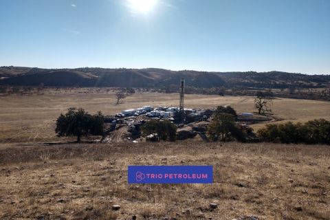
Trio Petroleum to Increase Monterey County Oil Production
2024-04-15 - Trio Petroleum’s HH-1 well in McCool Ranch and the HV-3A well in the Presidents Field collectively produce about 75 bbl/d.

Trillion Energy Begins SASB Revitalization Project
2024-04-15 - Trillion Energy reported 49 m of new gas pay will be perforated in four wells.