Learn more about Hart Energy Conferences
Get our latest conference schedules, updates and insights straight to your inbox.
1 Shell Offshore Inc., New Orleans, has reached total depth at its deepwater #1 OCS-G-23502 in the northeastern section of DeSoto Canyon Block 269 in the eastern Gulf of Mexico. The well, in 7,516 ft. of water, is the first of as many as four tests proposed by Shell in its plan of exploration. Shell isn't alone in the area. Devon Energy Inc., Oklahoma City, is drilling a wildcat in 7,030 ft. of water in DeSoto Canyon 180. The #1 OCS-G-23493 is the company's Tuscany prospect. The nearest proven well is BP's King's Peak in DeSoto Canyon 133. And, a well drilled by Total in nearby Mississippi Canyon 305 tested at 492.3 million cu. ft. of gas a day from Pliocene, according to IHS Energy. 2 Centurion Resources LLC, Fulton, Miss., has scheduled a 2,000-ft. wildcat in Itawamba County, Miss. The #1 FFM 4-1, in Section 4-9s-10e, is a mile west of two-well Holly Field, where the #1 and #2 Harris have produced 108.7 million cu. ft. of gas since 1993. Just 23 wells have been drilled in Itawamba County to date. 3 A wildcat has been scheduled in northeastern Escambia County, Ala., by Ventex Operating Co. of Dallas. The company will drill its #1 Chunn 2-9 to Smackover at 15,000 ft. in Section 2-3n-6e. A mile northwest, the single-well Vocation South Field produced about 75,000 bbl. of oil from Smackover. The strongest producer nearby is the #1 ATIC 10-10, a mile southwest. That well, the single producer in Chitterling Creek Field, tested with an initial potential of 317 bbl. of oil a day. It produced a cumulative 204,668 bbl. of oil, 548.8 million cu. ft. of gas and 1.23 million bbl. of water in six years. 4 Savoy Energy LP, Traverse City, plans a couple of Michigan wildcats. The company's #1-88 Professional Development Corp. in Section 8-28n-8e, Alcona County, will target Clinton Shale at 5,896 ft. The well is a mile east of East Hubbard Lake. Farther south in Section 30-25n-7w, Kalkaska County, the company will drill the #1-30B HD1 Borgen horizontal wildcat to Burnt Bluff at 8,467 ft. The well is about 11 miles east of Fife Lake, Mich., and 3.8 miles northeast of Cannon Creek Field, which produces from Traverse Lime, reports IHS Energy. 5 West Bay Exploration Co., Traverse City, has applied for a permit to drill the #1-28 Smith in Section 28-9n-13e in southwestern Sanilac County, Mich. The 5,200-ft. Niagaran wildcat will be drilled in a nonproducing township about two miles southeast of Brown City. The planned well is five miles north of the northernmost producer in Capac Field, which produces from Niagaran in St. Clair County. That well was the #1 James Armstrong Unit, in Section 21-8n-13e. It tested flowing 750,000 cu. ft. of gas a day when it was completed in 1967. 6 A mile east of North Patoka East Field, which produces from Geneva, Lincoln Oil & Gas LLC, Champaign, Ill., has scheduled a 4,250-ft. Trenton test at its #26-1 Brumfield. The well site is in Section 25-4n-1e, Marion County, Ill., about three miles east of Patoka. 7 Quicksilver Resources Inc., Fort Worth, continues its aggressive shallow Ordovician campaign in Harrison County, Ind. Among the latest wells in the series are the #C1-28 Wolfe, a Laconia Field development well in Section 28-4s-4e, and the #A1-29 Spalding wildcat in Section 29-5s-5e. Both wells are planned to 1,050 ft. Projected to the same depth are the #A3-26-Carter in Section 26-5s-4e, a wildcat outpost to Laconia Field, and the #B3-18 Hedden wildcat in Section 18-5s-4e, nearly a mile southeast of the field. 8 Nornew Inc., Jamestown, N.Y., has scheduled three wildcats in Madison County, N.Y. The wells are projected to Herkimer between 3,160 and 3,270 ft. The #1 Rollins is in Section F, West Easton Quad, Lebanon Township, nearly five miles southwest of Hamilton, N.Y. The #1 Wedge is in Section G, Hamilton Quad, Lebanon Township, about 5.5 miles southwest of Hamilton. The #2 Whitney is also in Section G, about five miles southwest of Hamilton. 9 Calgary-based Talisman Energy Inc., through its Fortuna Energy Inc. subsidiary, has completed a couple of successful Trenton-Black River wells on properties it recently acquired in New York. The #1 Konstantinedes, in Van Etten Quad, eastern Chemung County, tested at rates up to 10.4 million cu. ft. of gas a day. It is about three miles southwest of Van Etten. The #2 Ganung, Dix Township, Beaver Dams Quad, is southwest of the town of Montour Falls in southern Schuyler County, adjacent to Chemung County. That wildcat flowed 2.4 million cu. ft. of gas a day. The company also is drilling the #1 Hepfner in Big Flats Township, Big Flats Quad, Chemung County, to 10,000 ft. in Trenton-Black River. It anticipates drilling at least two more wells before the end of the year. In all, Talisman will spend some $46 million this year for eight wells. It already had some 67 million cu. ft. of gas a day in production from the area in July. To date, Talisman has acquired approximately 150,000 net acres of land, 115 billion cu. ft. of proved gas reserves and 55 million cu. ft. in daily production for $250 million. In March, it also picked up rights to 20,706 acres of land at a New York State lease sale for $3.9 million in bids, or $187.75 an acre. 10 Beldon & Blake Corp., North Canton, Ohio, plans a 10,150-ft. Trenton-Black River wildcat some 3.5 miles northeast of Binghamton in Broome County, N.Y. The company's #1 Burkowsky is some 18 miles east-northeast of Stagecoach Field, which produces from Oriskany and Helderberg. The planned well is in the Section H, Chenango Forks Quad, Kirkwood Township, about 4.5 miles east of Port Dickinson, N.Y. 11 Dominion Exploration & Production Inc., Houston, has staked a deep Lock Haven wildcat to 13,000 ft. in Bradford County, Penn. The well is in Section D, Gillett Quad, Wells Township, 8.3 miles south of South Port, N.Y. 12 Houston-based EOG Resources Inc. has permitted three wildcats looking for oil in Speechley at 4,000 ft. in Jefferson County, Penn. The #1104, #1105 and #1106 Kuntz B all are in Section B, McGee's Mills Quad, Henderson Township, 5.3 miles southwest of Fairview, Penn. 13 A number of wells are planned in Fayette County, Penn., by Atlas Resources Inc. The Moon Township-based operator will drill the #2 Janco to Upper Devonian at 5,000 ft. in Section B, New Salem Quad, Redstone Township. Also projected to Upper Devonian at 5,000 ft. are the #1 Chalfant and #2 Chalfant, both in Section B of the same township. The #3 Janco will target Berea at 5,000 ft., also in Section B. The #1 Teslovich, #5 Harper, #7 Croftcheck and the #3 Croftcheck are in Section A of Redstone Township. They will assess the Fifty Foot Sand at 5,000 ft. The #10 Jack C. Moore, aimed at Big Injun at 5,000 ft., is in Section C, Carmichaels Quad, Luzerne Township. The company also has scheduled the #1, #2, #3 and #4 Wozniak, all in Section H, Fayette City Quad, Jefferson Township. 14 Eastern American Energy Corp., Charleston, W.Va., plans a 13,500-ft. wildcat to test Knox about eight miles southwest of Spencer in Roane County, W.Va. The company's #1D Carter/McClung is in Harper District, Walton Quad, 2.6 miles south of Spencer Field, which produces from Dunkard B. 15 Stalkner Energy Corp., Glenville, W.Va., has submitted the paperwork for a 5,500-ft. wildcat in Calhoun County, W.Va., about five miles southeast of Thurmond. The #S-256-Despard will evaluate the Alexander formation 1.2 miles southwest of an unnamed field that produces from Big Lime, according to IHS Energy. 16 Two wildcats are on the way for Sundown Energy Inc., Dallas. Both wells are in Lewisburg Quad, Logan County, W.Va., and are projected to Corniferous at 1,490 ft. The #1 John Tabor is about six miles northwest of Russellville, Ky., and the #1 Larry Pitts is 6.4 miles northwest. 17 A series of wildcats are on the planning board for Bell County in eastern Kentucky for Lexington-based Daugherty Petroleum Inc. All four wells will look at Clinton shale at 4,000 ft. The #2 Jack Howard is in Balkan Quad; the #1 Jack Howard is in Wallins Creek Quad; the #1 John Parrot is in Artemus Quad; and the #5 Wayland Partin Unit is in Pineville Quad. Daugherty also has permitted locations for development wells in nearby Stoney Fork Field. 18 Knox Energy LLC Corp., Knoxville, has six wildcats lined up to depths between 3,275 ft. and 6,700 ft. in Anderson County, Tenn. It did not identify target formations. The #1013 CC and the #CC-1011 Coal Creek Mining & Manufacturing Co. are both in Fork Mountain Quad, about eight miles northwest of Oliver Springs, Tenn. The #1021 CC well is in Windrock Quad, nearly seven miles northwest of Oliver Springs, and the #CC1019 and #15 Coal Creek Mining & Manufacturing Co. wells are in Petros Quad. The first is about eight miles northwest of Oliver Springs and the second, about three miles northwest.
Recommended Reading

Uinta Basin: 50% More Oil for Twice the Proppant
2024-03-06 - The higher-intensity completions are costing an average of 35% fewer dollars spent per barrel of oil equivalent of output, Crescent Energy told investors and analysts on March 5.

Canadian Natural Resources Boosting Production in Oil Sands
2024-03-04 - Canadian Natural Resources will increase its quarterly dividend following record production volumes in the quarter.

NGL Growth Leads Enterprise Product Partners to Strong Fourth Quarter
2024-02-02 - Enterprise Product Partners executives are still waiting to receive final federal approval to go ahead with the company’s Sea Port Terminal Project.
Exxon, Chevron Tapping Permian for Output Growth in ‘24
2024-02-02 - Exxon Mobil and Chevron plan to tap West Texas and New Mexico for oil and gas production growth in 2024, the U.S. majors reported in their latest earnings.
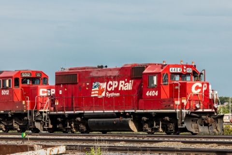
After Megamerger, Canadian Pacific Kansas City Rail Ends 2023 on High
2024-02-02 - After the historic merger of two railways in April, revenues reached CA$3.8B for fourth-quarter 2023.