Presented by:
![]()
Editor's note: This article appears in the E&P newsletter. Subscribe here.
GIS-powered platforms have been serving multiple industries for decades. However, the software has always been too complex for all but a few experts. Data visualization and mapping have recently evolved to meet the needs of the field services industry, making map-based project solutions accessible to all team members at field service companies.
With industrial companies pursuing digital transformation strategies, location services are becoming one of the essential technologies. In particular, there is a demand for tools that cater to a wide range of businesses with the power of geographic information systems (GIS).
GIS used to be a costly tool only used by a select number of engineers, but that is changing. Now industries of all kinds are finding new ways that GIS can improve the way they collaborate and serve their clients. Some services can be GIS-enhanced to perform necessary tasks more efficiently. Some can deliver value to customers precisely, time and location-wise, while some might track the delivery of sensitive data on multiple platforms.
New user-friendly tools to meet new business needs
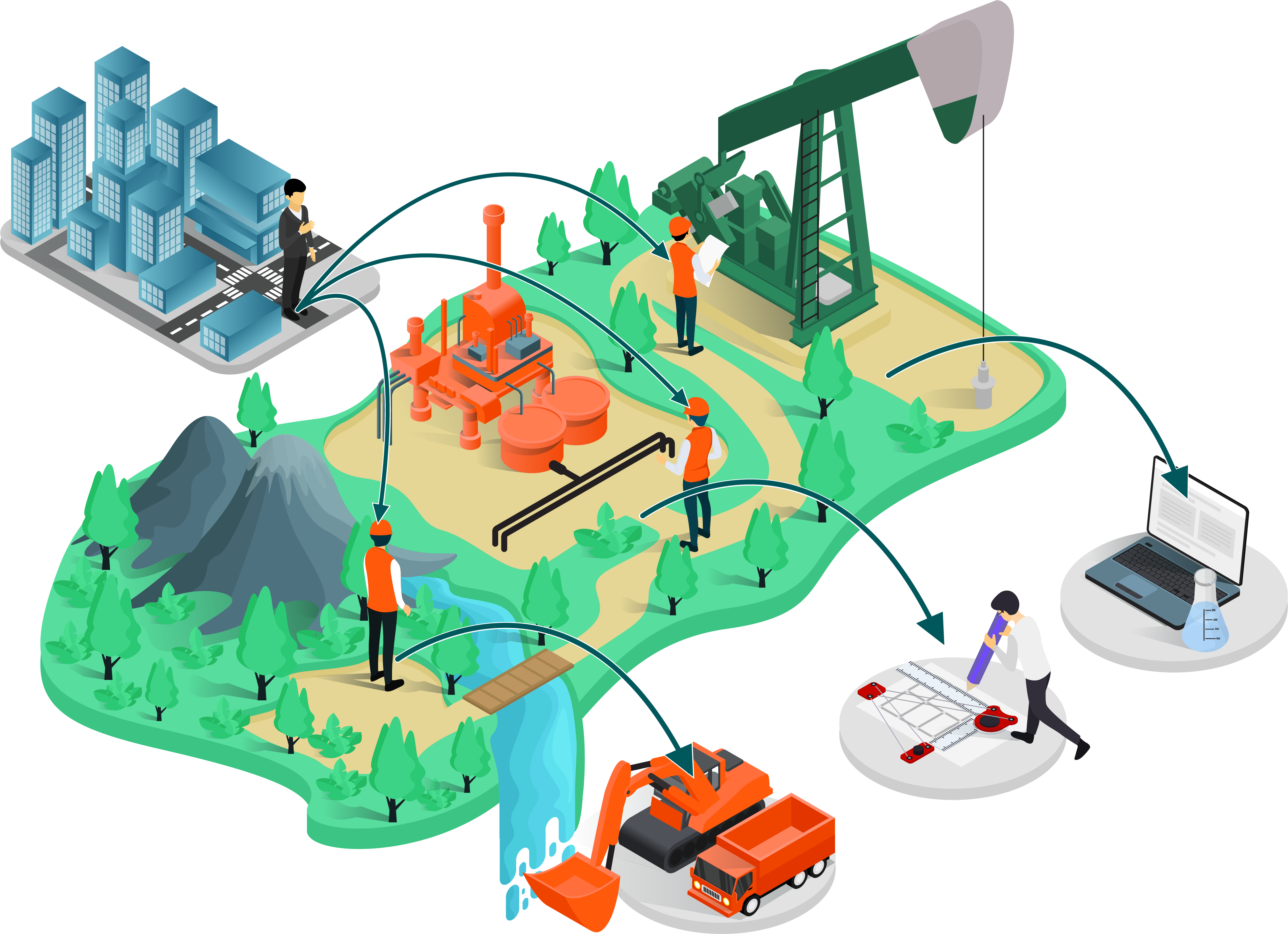
There is no doubt that with GIS being in demand within a range of multiple professional spheres like oil and gas or environmental consulting, there is also growth in the market of location-based software development. Specifically, those based upon location visualization can bring visibility and simplicity to a complex set of tasks, depending on a geospatial data component.
Understanding the importance of a map view feature within various fields, many engineering, construction, field services and environmental leaders are realizing that a more accessible GIS software solution is needed for minimizing operations risks while maximizing return on investment (ROI). The question at this point is in which form, at what speed and what integration cost of GIS software should be implemented to improve their business processes.
As more and more businesses are starting to utilize location services and platforms, particularly for project management, a variety of applications of different levels of complexity appears on the software market.
Some niche platforms, for example, are created for remediation and reclamation consultants. Moreover, the latest trends in environmental services proved that GIS is beneficial for environmental data analysis and planning of all levels.
Traditional project management is getting a facelift
Environmental agencies have always had to deal with large arrays of data from myriad sources. For each project, teams work on various tasks, bringing information from the field, laboratories, government offices and other sources. Most teams, however, would require different tools and subscriptions to collect and analyze data.
Another identified need within field services is real-time updates and collaboration. At times, data can be sensitive and greatly depend on the time of delivery. In cases of delay, the company will have to carry all costs and push deadlines and completion estimations. And on top of it all, hundreds of permits, forms, spreadsheets and maps are constantly being used by all team members.
A paper-based approach in project management is never an ideal strategy. However, for some reason, some companies resist the change toward software-based project management. But for those businesses that dare to shift operations, new efficiencies and better collaboration are changing the game for them.
Changing market realities require a more modern set of digital tools
The business landscape has shifted since the early spring of 2020. When COVID-19 struck, the whole world seemed to go into a remote mode. It became apparent that remote project collaboration and location visualization within particular industries are crucial and securely established.
New GIS platforms that support project management have experienced growth in demand and a spike in development. The market for map-based platforms is expanding significantly, and finding a perfect GIS-based project management platform match is not a simple task.
There is no doubt, any location-based intelligence within a project management platform is an excellent solution for many service, manufacturing and technical industries. It is truly a great and effective answer to planning and operations tasks of all sorts. Various assets of the company, geographically specific objects required to be analyzed, remotely located parts of the infrastructure, agricultural resources, and so many more elements of project portfolios can be visualized and managed from mobile applications.
Connecting more team members with the data they need in real time
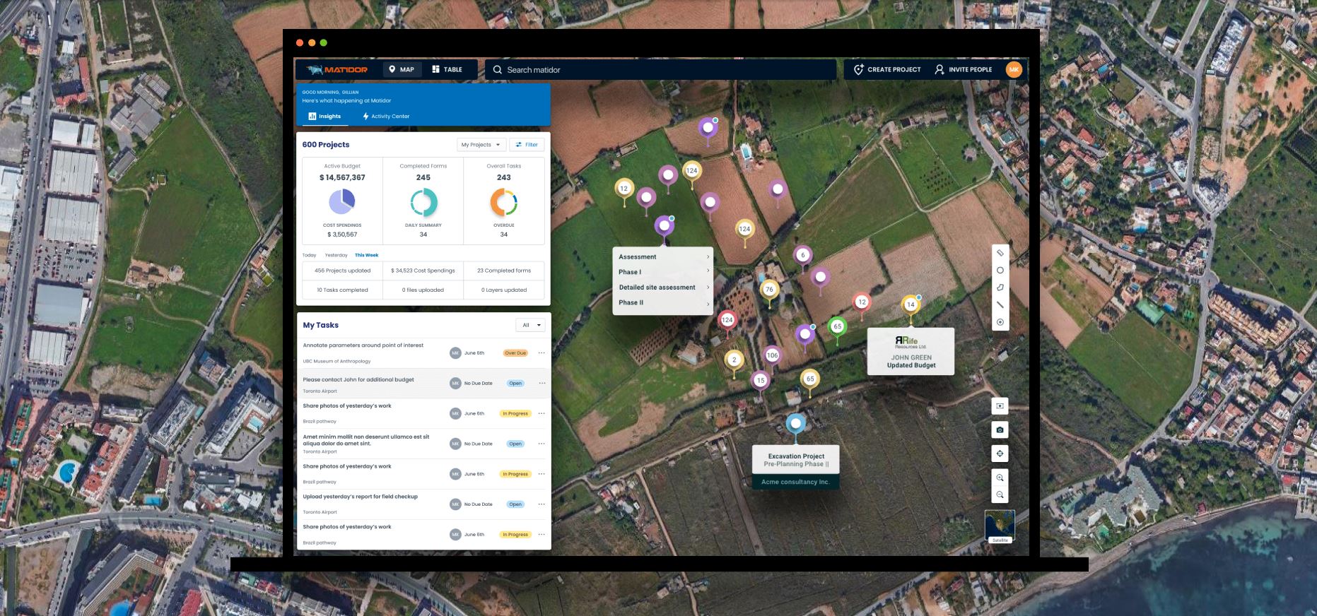
The collaboration part of the technology enhances business exploration and development activities and increases ROI while saving costs and boosting efficiency. The most cost-effective way to achieve this is with a turnkey GIS solution for nontechnical professionals. Matidor, a platform developed by GIS and project management professionals for all types of teams, is sector agnostic and highly integrated.
It is of utmost importance to have improved communication among stakeholders for better and faster decision-making and smart budget allocation, and many more tools available at the hands of project managers.
This is precisely the solution to a market gap identified and described above. The Matidor platform was designed to handle location visualization and project collaboration at once. Nontechnical users can utilize it without being dependent on GIS professionals, and all team members can access it without the usual expense of traditional GIS solutions.
Maps make data easier to visualize and understand
With Matidor's interactive map interface, geospatial and project information relating to physical locations can be readily seen and understood by technical and business audiences thanks to its intuitiveness and connectivity with third-party applications.
This one-stop technology gives companies total visibility over their entire operation portfolio on a map, which can be zoomed in at any time for a specific project's site layout, tasks, budgets, expenses, files and historical activities. Rapid access to information improves efficiency, enables better decisions and reduces safety and financial risks.
In addition, Matidor's unlimited sharing eliminates the collaboration hurdles between companies and unlocks new business development opportunities.
A perfect storm of opportunity for environmental consultants
Lately, the Canadian government has increased pressure and incentive to reduce liabilities from the ever-growing number of abandoned wells. One of Matidor's early clients, Rife Resources Ltd., a private E&P company owned by the CN Pension Trust Funds, recognizes the importance of managing its existing sites' land reclamation and environmental impact. Matidor.com helped Rife eliminate its "spreadsheet nightmare" and increase project management capacity by 492%.
Rife didn't have a reliable system to manage and track their abandonment and reclamation projects. Their existing in-house tools were more focused on reporting and could not capture daily project updates.
Critical data such as project priority, files and to-dos were managed in individual spreadsheets.
Project information was not available at the team's fingertips; every day, team members gathered the necessary updates from different sources (e.g., spreadsheets, docs and emails). This inefficient information flow resulted in miscommunication, data discrepancies and missed project goals.
With Matidor, Rife was able to save hundreds of hours of data hunting while managing up to five times more projects with the same team. The powerful mapping interface reduced unnecessary and costly onsite travels by up to 30%. Ultimately, rapid access to information improved efficiency, enabled better decisions and reduced financial risks.
Field-tested and adaptable to even the most remote working conditions
The platform is constantly evolving, updating the usability and partnering up with various data providers for better visualization. Recently, an offline synching option has been introduced, allowing field services professionals to update their projects without a network connection.
Matidor is not just another regular standalone GIS application. It is a multifunctional project management and visualization tool that can serve many industries and makes sure the project information is visual, detailed and available for professionals and collaborators at all times.
Recommended Reading
BP Restructures, Reduces Executive Team to 10
2024-04-18 - BP said the organizational changes will reduce duplication and reporting line complexity.

Matador Resources Announces Quarterly Cash Dividend
2024-04-18 - Matador Resources’ dividend is payable on June 7 to shareholders of record by May 17.
EQT Declares Quarterly Dividend
2024-04-18 - EQT Corp.’s dividend is payable June 1 to shareholders of record by May 8.

Daniel Berenbaum Joins Bloom Energy as CFO
2024-04-17 - Berenbaum succeeds CFO Greg Cameron, who is staying with Bloom until mid-May to facilitate the transition.

Equinor Releases Overview of Share Buyback Program
2024-04-17 - Equinor said the maximum shares to be repurchased is 16.8 million, of which up to 7.4 million shares can be acquired until May 15 and up to 9.4 million shares until Jan. 15, 2025 — the program’s end date.