
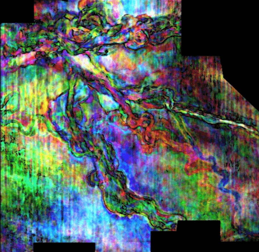
GeoTeric software allows interpreters to extract three different frequencies on a surface, enhancing the image. (Source: GeoTeric)
While there has been some light at the end of the gloom-and-doom tunnel lately, companies are still attempting to reinvent themselves in a down market, finding ways to spend less and work smarter. At BHP Billiton Petroleum, it’s all about transformation, according to Hunter Lockhart, an associate geologist.
But Lockhart isn’t just focusing on cost-cutting. “The other side of transformation, the way I see it, is transforming the way we work,” Lockhart said, “becoming more efficient, doing more with less, cutting down on the time it takes to interpret and deliver products that we need to deliver while simultaneously enhancing the quality of those products.”
His approach to doing this is to find ways to apply software products in unique ways. Two of the softwares he uses on a daily basis are PaleoScan, a new interpretation software from French company Eliis, and Geo-Teric from ffA. Lockhart said that PaleoScan is truly a transformational software because it automates the formerly manual process of picking lines in seismic data.
With PaleoScan Lockhart can load a seismic volume, input a few initial conditions and do simultaneous horizon interpretations, achieving a finished product in days rather than weeks. The software also increases the precision with which he can interpret.
PaleoScan works by using an algorithm that takes into account wavelet similarity as well as the relative distance between node points. “When the wavelet has a strong similarity and a short distance from one node point to another, it matches that up and is able to interpret horizons through that,” he said. Once the program runs, the interpreter can manually edit the time relationships and then extract horizons of interest for further interpretation. It works particularly well in areas of difficult geology, he said.
The output from PaleoScan becomes the input for GeoTeric. “When you pair PaleoScan with GeoTeric, the power of PaleoScan increases exponentially, and that’s where true value is created,” he said. GeoTeric is an imaging software that was originally designed for the medical industry, and Lockhart said that it’s also great for seismic visualization. One attribute of the software involves applying different colors—red, green and blue—to different frequencies and then blending the colors to generate a derivative seismic volume, enhancing the ability to image the subsurface.
Lockhart showed an example offshore Trinidad and Tobago where PaleoScan had identified a horizon representing a surface from the Cenozoic. “These surfaces are important because they can really help us better understand the geology of our area of interest at the time of deposition of key elements,” he said. “I image that surface and extract three different frequencies on that surface in GeoTeric that allow me to enhance the image in a way that no one has seen before.”
Using these types of high-tech products to their fullest extent is enabling Lockhart and other BHP Billiton explorers to truly utilize the power of exploration technology, he said. And the results speak for themselves. One example showed channels imaged 6,000 m (almost 20,000 ft) beneath the surface. “That’s more than 3 miles [4.82 km],” he said. “And it’s as clear as a satellite image of the Nile River system.”
Recommended Reading
TPG Adds Lebovitz as Head of Infrastructure for Climate Investing Platform
2024-02-07 - TPG Rise Climate was launched in 2021 to make investments across asset classes in climate solutions globally.
Air Products Sees $15B Hydrogen, Energy Transition Project Backlog
2024-02-07 - Pennsylvania-headquartered Air Products has eight hydrogen projects underway and is targeting an IRR of more than 10%.

NGL Growth Leads Enterprise Product Partners to Strong Fourth Quarter
2024-02-02 - Enterprise Product Partners executives are still waiting to receive final federal approval to go ahead with the company’s Sea Port Terminal Project.
Sherrill to Lead HEP’s Low Carbon Solutions Division
2024-02-06 - Richard Sherill will serve as president of Howard Energy Partners’ low carbon solutions division, while also serving on Talos Energy’s board.
Magnolia Appoints David Khani to Board
2024-02-08 - David Khani’s appointment to Magnolia Oil & Gas’ board as an independent director brings the board’s size to eight members.