Conventional reservoirs generally have been the easiest and least expensive reservoirs to drill and exploit, and when drilled successfully, they usually are the most profitable. Finding prospects that are geologically suitable, as well as economically efficient, has always been the biggest issue for conventional operators. As such, operators have searched for a tool that can reduce the risk from the drilling targets. Electroseismic data might be the tool that these conventional operators have been looking for. The unique ability to image the location of hydrocarbon reservoirs in the subsurface changes the way companies evaluate and drill prospects.
Electroseismic theory
Exploration geologists and geophysicists constantly are looking for ways to reduce risk in the prospects they develop, and detecting the presence or absence of hydrocarbons is the fundamental factor in reducing that risk. Electroseismic technology utilizes the natural phenomenon that couples electromagnetic and seismic energies together through the medium of porous rock. An applied electric field acts on ions in the aqueous phase that, in turn, drags fluid particles as the ions move with the electric field. The resultant fluid flow reacts against the rock grain matrix to generate a compressional seismic wave that can be measured at the surface. The fundamental factor that makes this technology suitable for hydrocarbon detection is that the electroseismic coupling is significantly enhanced in the presence of electrically resistive oil and gas in the rock pore space.
The physics behind electroseismic is not new as the natural phenomenon began to be understood in the 1930s, and research in the oil and gas industry has been ongoing since the early 1990s. Active source methods were tested and proved by an oil company but abandoned because of the cumbersome logistics associated with large electric sources. The relinquishments of the active source method led ES Xplore (through Hunt Oil’s venture capital group) to research and develop a passive method of electroseismic imaging that utilizes the earth’s existing electric field as the source. The passive nature of the data collection allows fieldwork that is nonintrusive and efficient, qualities that other subsurface imaging techniques do not have.
Operational benefits
There are significant operational benefits to electroseismic data outside of the environmentally friendly data collection. Many of these benefits are based on the fact that each survey point is independent and autonomous to all other survey points. This has proved extremely important when working around complex permitting and land situations. The result is that electroseismic data covering small surface areas can still have full-quality subsurface imaging even if patches of land remain impossible to permit. This survey point autonomy also can have large technical value. If the resolution of a survey is deemed to be too low, points can be infilled and added to the old survey without requiring the old survey points to be re-shot. Also, if an electroseismic survey needs to be expanded geographically, there is no need to overlap surveys, and new data can be collected starting from the edge of the old survey.
Additionally, the processing and interpretation of electroseismic data is extremely efficient with final data being returned to the client within 30 days. This time efficiency means tough choices about drilling to keep leases HBP can be made on a scientific basis. This flexibility allows clients who utilize the electroseismic data to conform this new technology to their needs.
Resultant electroseismic data
The output data from an electroseismic survey mimic a well log or a singlefold seismic section from the early days of exploration (Figure 1).
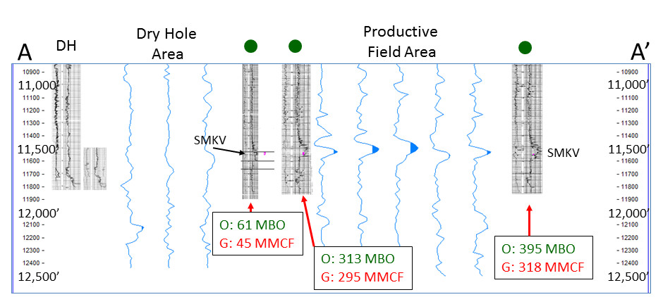
The nature of the gridded acquisition design provides multiple responses across the surface of a given polygon. These data are then contoured to provide a detailed outline in map view of potential hydrocarbon indication at specific depths within the area of interest.
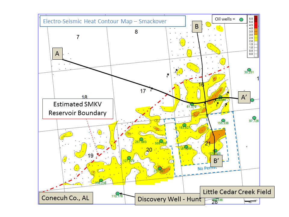
Figure 2 is a data example from the Little Cedar Creek Field in Alabama showing the original discovery well and the failed step-out well. Upon review of these data, one might assume that the operator would have made a different decision on the location of the stepout well if it would have had electroseismic data to assist in the decision-making.
De-risk conventional prospects
For now, the value of electroseismic data is in evaluating conventional targets. Operators can de-risk these plays because the resultant data can indicate the presence or absence of hydrocarbons. Until now, the de-risking technologies of conventional plays rested in the hands of extensive and expensive 3-D seismic acquisition and processing to determine the likelihood of a successful prospect. Electroseismic data add another tool in the toolbox for conventional operators, one that can complement seismic data and, in many cases, stand alone in providing information that has a direct impact on E&P companies’ bottom lines. The combination of unique and revolutionary data along with a drastically different operational timeline and approach all combine to make electroseismic data an exciting new option for conventional operators.
Recommended Reading

McDermott Consortia Scoops Up Two Ruya Project Contracts
2024-02-01 - The EPCIC contracts support the expansion of the offshore Al-Shaheen Field, Qatar’s largest oil field.

E&P Highlights: Feb. 26, 2024
2024-02-26 - Here’s a roundup of the latest E&P headlines, including interest in some projects changing hands and new contract awards.
US Raises Crude Production Growth Forecast for 2024
2024-03-12 - U.S. crude oil production will rise by 260,000 bbl/d to 13.19 MMbbl/d this year, the EIA said in its Short-Term Energy Outlook.
Iraq to Seek Bids for Oil, Gas Contracts April 27
2024-04-18 - Iraq will auction 30 new oil and gas projects in two licensing rounds distributed across the country.

For Sale, Again: Oily Northern Midland’s HighPeak Energy
2024-03-08 - The E&P is looking to hitch a ride on heated, renewed Permian Basin M&A.