Presented by:
![]()
This article appears in the E&P newsletter. Subscribe to the E&P newsletter here.
Oil and gas cuttings samples have traditionally been overlooked when it comes to a data source. Indeed, many geological samples have simply gathered dust in geological core repositories.
However, in line with ongoing digitalization, those in the sector will have noticed a shift in momentum behind the concept of cuttings digitalization. More and more of those in the geoscience community are realizing the potential for integrating cuttings data into subsurface machine learning (ML) workflows to support accurate and insightful decision making.
To support the appetite to get the most out of what was a previously an untapped data-source, Earth Science Analytics recently announced a collaboration with Rockwash Geodata, a geological laboratory and services company. The partnership will see Earth Science Analytics combine its technical expertise with its software, transforming vast quantities of dormant oil and gas data into high-value digital assets.
The challenge
While the value of visual cuttings data is increasingly being viewed as an important source of industry information, utilizing the available data has so far proved challenging. The cuttings data were always there, but access required physical visitation. To make matters worse, the workload and time required to contextualize and analyze the data led many to overlook the cuttings as a viable source of information.
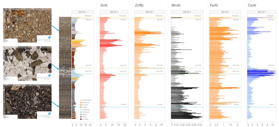
Rockwash Geodata’s efforts have gone a long way to change this. The team has brought thousands upon thousands of important geological resources into the digital environment. An extensive collection of digital datapoints throughout the entire stratigraphic section of many wells worldwide now exists thanks to Rockwash Geodata’s efforts. This digitally available data have also generated an excellent candidate dataset for computer-driven deep learning techniques.
The solution
The collaboration sees the amalgamation of Earth Science Analytics' web-based cloud-native geoscience software and Rockwash Geodata’s geological expertise. Rockwash Geodata’s experts can now take a proprietary database of cuttings photographs and, using ML workflows from Earth Science Analytics, categorize the photos in terms of bulk lithology. This creates a fully labeled dataset of cuttings sample photographs.
By working together, the companies can democratize the image data. This ensures they can better contextualize and visualize the images, establishing trends to make predictions and support better business decision making.
By combining these newly created digital inputs with a quality assured set of traditional log suite curves, Earth Science Analytics can generate a set of high-quality rock property predictions, which can be used to build larger, reservoir-scale interpretations. This will support petrophysical and geoscience workflows by providing another layer of understanding and confidence to the rock property predictions.
And as these digital images from thousands of cuttings samples have now been produced, the ML workflows can help to maximize their value. Put simply, the collaboration is helping operators to maximize the value from cuttings data.
The process
To create value from an image, we must embrace a data-centric or label-centric approach.
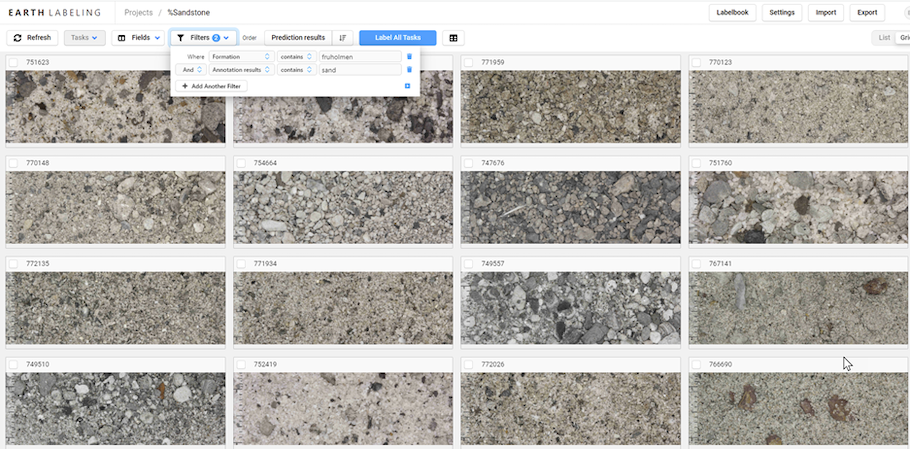
The introduction of knowledge by industry experts via labeling has always been required in the quest to deliver accurate models. In this case, Earth Science Analytics experts focus on creating a collection of ontologies that are focused on extracting the important information from the cutting samples.
Earth Science Analytics' process begins by working with Rockwash Geodata to contextualize the digital cuttings images, understanding the information that is stored in each one. By properly contextualizing all datasets and types, the companies aim to propagate data across scales, from the very small to the very large. Secondly, they label each image, adding human expertise and leveraging auxiliary data such as stratigraphic information.
Once this stage is complete, Earth Science Analytics uses computer vision methods to train ML models, helping to support rich, fast and large-scale interpretation of the images.
Finally, integration takes place, as cuttings are reviewed alongside other well-log data and seismic data. This provides valuable QC steps and allows Earth Science Analytics to propagate information, supporting and accelerating the business decisions of its clients.
Supporting efficient operations
Earth Science Analytics' new partnership means these previously often untapped assets can provide real data value, helping those in the geoscience community get a broader picture of the subsurface.
This approach ensures users can not only confirm the things they already know, but also cast a light on what they don’t. Users can see examples of good formations, but also where there may have been a particular unexplained drilling problem, helping provide the solution to many unanswered questions.
Ultimately, this will allow those in the E&P sector to become more efficient, as the extra information available will reduce the risk of drilling dry wells. Not only that, but while cuttings-scale interpretation workflows are essential for good business decision-making in oil and gas exploration, they can also be used wider for sub-surface CO2 storage and mining industries.
This technology will enable and accelerate digital transformation across multiple sectors, and Earth Science Analytics looks forward to its collaboration to create real value from AI-ready digital cuttings data.
About the author: Eirik Larsen is co-founder and chief solutions officer of Earth Science Analytics.
Recommended Reading
BP Restructures, Reduces Executive Team to 10
2024-04-18 - BP said the organizational changes will reduce duplication and reporting line complexity.

Matador Resources Announces Quarterly Cash Dividend
2024-04-18 - Matador Resources’ dividend is payable on June 7 to shareholders of record by May 17.
EQT Declares Quarterly Dividend
2024-04-18 - EQT Corp.’s dividend is payable June 1 to shareholders of record by May 8.

Daniel Berenbaum Joins Bloom Energy as CFO
2024-04-17 - Berenbaum succeeds CFO Greg Cameron, who is staying with Bloom until mid-May to facilitate the transition.
Equinor Releases Overview of Share Buyback Program
2024-04-17 - Equinor said the maximum shares to be repurchased is 16.8 million, of which up to 7.4 million shares can be acquired until May 15 and up to 9.4 million shares until Jan. 15, 2025 — the program’s end date.